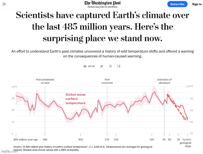
Any debate on global warming now OVER!?

Photos cannot be used to accurately measure sea level rise because they cannot account for fluctuations in tide levels, which can significantly alter the apparent waterline in a picture, making it difficult to distinguish actual sea level changes from natural tidal variations, even when comparing photos taken at the same location at different times; additionally, photos lack the precise data needed to measure sea level change, which is best obtained through dedicated instruments like tide gauges and satellite altimetry.
I’m not using photos for accuracy, I use photos to show that water hadn’t risen.

Are you suggesting you can measure accurately?
 
  • Informative
Reactions: EMH
All I can tell you is to maybe do some searches and discover the truth for yourself. I did. I don't care enough to convince you of it. It's pretty obvious to me that the data shows that in an interglacial period the oceans and the atmosphere will warm and that sea levels will rise. To argue that isn't going on in an interglacial period would be pretty ridicuous and unsupported by the empirical evidence from the geologic record.

But hey, if you want to believe there is no warming or that seas aren't rising, good luck with that. I won't be supporting that because I have studied the evidence.
Evidence you can’t post.
 
I can't believe you are making the same ridiculous argument that EMH is making. But call me son again and I'll show you the other side I held back the other day. Fair enough?

Maybe in your world a static sea level makes sense but anyone who has actually studied sea level data knows better. This is especially true for the past 3 million years.
You are really a EMH follower huh? Not me
 
Evidence you can’t post.
I disagree.
1736558304776.webp
 
I’m not using photos for accuracy, I use photos to show that water hadn’t risen.

Are you suggesting you can measure accurately?
By arguing there has been no rise, you are indeed effectively saying you are using the photos to measure sea level rise and that there is none which is ridiculous because it's been rising since the last glacial maximum.
 
I’m not using photos for accuracy, I use photos to show that water hadn’t risen.

Are you suggesting you can measure accurately?


and they do not have ONE SINGLE PHOTO documenting "ocean rise"

NOT ONE
 
By arguing there has been no rise, you are indeed effectively saying you are using the photos to measure sea level rise and that there is none which is ridiculous because it's been rising since the last glacial maximum.


A faux skeptic funded by the taxpayer.

Job = push morons to accept FUDGED FRAUD as "climate data."
 
A faux skeptic funded by the taxpayer.

Job = push morons to accept FUDGED FRAUD as "climate data."
Incorrect. Empirical evidence from the geologic record.
1736559734762.webp
 

More relevantly YOU IDIOT!​

The Pliocene: The Last Time Earth had >400 ppm of Atmospheric CO2

Royal Meteorological Society

The last time carbon dioxide was so plentiful in our planet's atmosphere was in the Pliocene era, around 3 million years ago. Life on Earth was dominated by giant mammals; humans and chimps had shared their last common ancestor.
Although the Sun's force was about the Same, the Sea Levels were 15 Metres (50') Higher and Arctic summer temperatures were 14 degrees higher than the present day.".."

The Pliocene: The Last Time Earth had >400 ppm of Atmospheric CO2

The Pliocene: >400 ppm of Atmospheric CO2
www.rmets.org
www.rmets.org


And CO2earth:

kc-monthly-0580.png


`
 
Incorrect. Empirical evidence from the geologic record.
View attachment 1064052


The CO2 concentration is correct and unchallenged.

The temp chart isn't even a temp record, it is one Antarctic ice core's Oxygen isotope ratio, near to tectonically active Antarctic Peninsula, corroding questionable data to start with. Worthless...

Sea level chart is complete McBullshit, and the "recent rise" is 100% BULLSHIT
 

More relevantly YOU IDIOT!​

The Pliocene: The Last Time Earth had >400 ppm of Atmospheric CO2

Royal Meteorological Society

The last time carbon dioxide was so plentiful in our planet's atmosphere was in the Pliocene era, around 3 million years ago. Life on Earth was dominated by giant mammals; humans and chimps had shared their last common ancestor.
Although the Sun's force was about the Same, the Sea Levels were 15 Metres (50') Higher and Arctic summer temperatures were 14 degrees higher than the present day.".."


The Pliocene: The Last Time Earth had >400 ppm of Atmospheric CO2

The Pliocene: >400 ppm of Atmospheric CO2
www.rmets.org
www.rmets.org


And CO2earth:

kc-monthly-0580.png


`


The CO2 chart is accurate, the rest is CO2 FRAUD bullshit.

3 million years ago Greenland was green, Antarctica's ice age was 36+ million years old, and there were 5+ million cubic miles of ice on North America... sea level was not higher.
 
The CO2 concentration is correct and unchallenged.

The temp chart isn't even a temp record, it is one Antarctic ice core's Oxygen isotope ratio, near to tectonically active Antarctic Peninsula, corroding questionable data to start with. Worthless...

Sea level chart is complete McBullshit, and the "recent rise" is 100% BULLSHIT
Polar regions are most affected by climate changes. They are the regions which warm the most and cool the most and fluctuate the most. So ice core data is vastly superior to global temperature reconstructions. Sea level data is based upon tons of evidence from geologic observations. You might as well be arguing geology is worthless.
 
Polar regions are most affected by climate changes


Actually the polar regions are the regions where the amount of land in them dictates climate...


They are the regions which warm the most


Over millions of years, not 150....


So ice core data is vastly superior to global temperature reconstructions


The ice core temp chart is just as laughable as the sea level one. Sea level isn't rising, and neither are temperatures, so both are wrong about the RECENT PAST, so why would anyone pay any attention to them about further back...

THEY ARE WRONG
 
Actually the polar regions are the regions where the amount of land in them dictates climate...
The polar regions are the regions that receive the least amount of sunlight. It's a known fact that the polar regions have the largest swings in temperature differentials when climate changes. Stop try to obscure this fact with your bullshit red herring polish logic.
 
The ice core temp chart is just as laughable as the sea level one. Sea level isn't rising, and neither are temperatures, so both are wrong about the RECENT PAST, so why would anyone pay any attention to them about further back...

THEY ARE WRONG
You are very consistent in being wrong. Tell me more about your fake physics degree.
 
It's a known fact that the polar regions have the largest swings in temperature differentials when climate changes


The question is what causes the climate change...


Back
Top Bottom