Which ones?
I'm not panicked or anything....

I used to live in the San Bernardino mountains. I don't know where you are there. I can tell you that it was rumored in the late 60's and into the 70's that California would be falling off into the ocean and a lot of people scattered for other states.
Thinning the herd?
Yo, Gallant one. I found Anchorage recent info on that 1/23/2019 shakeup near the 1/08/2019 one was. Seems there was a big earthquake in AK in 1953, when my family was there. Prayers up for all of you in the Ring of Fire area!


Thanks, Beau! Living in an area susceptible to any disastrous possibility makes you aware. I grew up in hurricane country but am pretty unconcerned about those kind of storms now. Earthquakes and volcanoes occupy my disaster awareness now.
Don't get too comfortable there, sir. Hopefully you are a little inland, but I had this nagging recollection of seeing a picture of tsunami damage to an area of Alaska coastline that rose up hundreds of feet only to get a bit washed from people there who didn't worry. See if I can find it. It may have happened 100 years ago for all I know now.
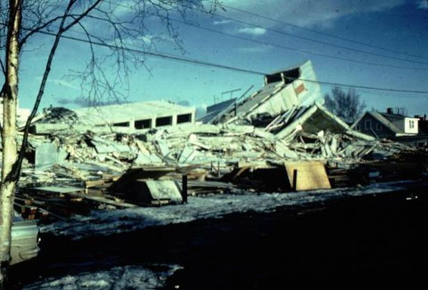
Not a hundred years, but 1964, according to my finding here:
https://www.history.com/topics/natural-disasters-and-environment/1964-alaska-earthquake
1964 Alaska Earthquake Changes the Coastline
Four minutes may not seem like a long time, but when it comes to earthquakes, it seems an eternity, and tremors during the great Alaska earthquake of 1964 lasted at least four minutes.
Geological surveys taken immediately afterward showed parts of the Alaskan coast sank up to eight feet, other parts rose up to 38 feet and much of the coast moved 50 feet towards the ocean. Coastal forests plunged below sea level and were destroyed by salt water.
Local Tsunamis and Landslides
As the tremors ended, local tsunamis sprung up almost immediately, leaving residents little to no time to flee for higher ground.
A massive tidal wave crushed the small, coastal village of Chenega four minutes after the tremors subsided—the town lost a third of its population. Local tsunamis also caused destruction in Kodiak, Whittier and Seward.
Downtown Anchorage had the most property damage mainly due to immense landslides, one of which dropped the business district nine feet.
In the Turnagain Heights area of Anchorage, soil liquefaction (when the ground behaves like a liquid) triggered a landslide which moved parts of a suburban bluff 2,000 feet into the bay, taking up to 75 homes with it.
The control tower at Anchorage International Airport collapsed, killing an air traffic controller. Part of the of the Million Dollar Bridge at Copper River also crumpled.
Thousands of strong aftershocks continued for weeks after the earthquake, some measuring greater than magnitude 6.2. Reports of residual water sloshing (seiches) came in from the U.S. Gulf Coast and as far away as Australia.
And I hope this doesn't happen to ya'll up there in the Last Frontier State, but please, in spite of the awful cold, please maintain vigilance out there and up there where you've had a couple of scares lately when it comes to temblors.. More prayers up and only good wishes for whatever is going on in our west coast trouble spots along the Ring.


 38 (UTC)
 23 (UTC)
 33 (UTC)
 43 (UTC)
 20 (UTC)