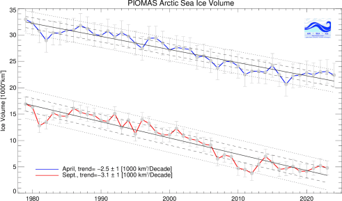
Well, let's see. Maximum coverage from 1979 to 1989 was about 14.5 million square kilometers. For the last ten years, it has been about 13.5, so that is about a
.......................... You were sooo close to being right Roxy.. Go ahead use a calculator...

What happpened there? A GW warming caused forest fire start in your den?
No, a phone call came in from my brother about a funeral for a death in the family. Hit the post button without thinking about it.
So, the decline for the average for those ten year periods is about 7%. So, what has happened to the decline of the lowest extent, and how does that relate to the the decline of the highest extent?
For the lowest extent, in September, from 1979 to 1989, is about 5.25 million square kilometers. For 2005 to 2015, it is about 3.25 million square kilometers. That is about a 38% decline. That is very significant.
http://arctic.atmos.uiuc.edu/cryosphere/IMAGES/seaice.area.arctic.png


 Matthew is still calculating I guess.