Arctic Ice Off on Good Start this Season.


You didn't address my statements at all just another chart YOU posted that actually supports me since it shows what my chart showed that the decline STOPPED after 2007 You really can't read your own charts well.

Here is what your favorite PIOMAS chart showing that the decline stopped after 2008 it is so obvious, but I predict you will lie to yourself and scream too because you have serious problems dealing with reality.

piomas-ice-volume-to-mar-2021.png


Epic fail on your part.
 
Last edited:
LOL But you don't dare show them, do you. Because they show your massive increase 2 million square kilometers less than the starting amount in 1979. You silly ass deniers are such losers.


Your first chart clearly shows that the decline stopped after 2007 as does the video in the second link a reality you are fighting very hard because you are so deep into the climate cult bullshit.

No one dispute the decline since 1979, but it is misleading and only 42 years long the 1979 to now sea ice charts have been posted THOUSANDS of times now so you can stop lying about it as no one disputes the obvious decline and that it doesn't support the CO2 narrative anyway since there have been many published papers showing far less to zero summer ice from the MWP and earlier in the interglacial period when CO2 hung around the 260-280 ppm for thousands of years clearly CO2 isn't the cause of the sea ice changes over the centuries.

You are doing terribly with your fearmongering bullcrap.
 
It is guess work when it comes to ice

Actually ... scientists use a thing called a "ruler" to measure ice and snow ... drop by your local grammar school and ask one of the kids if you're not familiar with what a ruler is and how it's used ... maybe your grandparents have one kicking around their attic ...
 
Last edited:
Actually ... scientists use a thing called a "ruler" to measure ice and snow ... drop by your local grammar school and ask one of the kids if you're not familiar with what a ruler is and how it's used ... maybe your grandparents have one kicking around their attic ...
Ask my grandparents? They are dead you lowlife scum fuck. How about following forum rules and leave my family out of your comments.

As far as wooden rulers go, they are not used out side of grade schools and morons such as yourself playing in the bathroom.

You can't calibrate a wooden ruler hence we find the dimwitted suggesting that they are used in science.

Further, rulers are in inches, science uses SI units.

Yep, you won't find wooden rulers in any laboratory you fucking mental midget.
 
The problem could be that the satellites are ACTUALLY too accurate. You see that when they changed from shorebased tide gauges and a handful of buoys to the satellite record. The sats now measure ALL of the ocean the oceans are NOT FLAT.

The sat accuracy is just about sub-millimeter. The MEAN flatness of the oceans varies by maybe 2 or 5 millimeters. And CURRENTS and WINDS are largely responsible for that. And they WILL change with weather.

So when measure the AVG rise in Sea level across the oceans for the entire SAT record -- MOST of the sea level rise is in these SAME AREAS where the oceans are traditionally higher than the rest of world.

Could find a "mean sea level" pic showing the higher spots. But it's roughly the SAME as this chart showing the "anomaly" of measured SLevel rise over the satellite record.

Mean_sea_level_trends_node_full_image_2.jpg


NOTE: that the VAST MAJORITY of "sea level rise" attributed to global warming is NO WHERE NEAR COASTLINES !!!!!! And wouldn't have been measured AT ALL by the tide qauge systems.
Or, the data must be interpreted and applied or computer modeled.

Old ice vs new ice?
What about ice with water on it?

Seems I may have brought up much of this in the past. Like what type of sat is used? What type of data is collected.

Certainly a satellite is not using a wooden ruler like reiny daze stated.

Satellites are not even close to being accurate. Why do you think all them there scientists got stuck in the ice down at the Antarctica all those years ago.. They needed real measurments

Do YOU know what the resolution of Satellites measuring Sea Ice?
 
Ask my grandparents? They are dead you lowlife scum fuck. How about following forum rules and leave my family out of your comments.

As far as wooden rulers go, they are not used out side of grade schools and morons such as yourself playing in the bathroom.

You can't calibrate a wooden ruler hence we find the dimwitted suggesting that they are used in science.

Further, rulers are in inches, science uses SI units.

Yep, you won't find wooden rulers in any laboratory you fucking mental midget.

Oh, dear you have badly misunderstood his sarcasm.
 
Ask my grandparents? They are dead you lowlife scum fuck. How about following forum rules and leave my family out of your comments.

As far as wooden rulers go, they are not used out side of grade schools and morons such as yourself playing in the bathroom.

You can't calibrate a wooden ruler hence we find the dimwitted suggesting that they are used in science.

Further, rulers are in inches, science uses SI units.

Yep, you won't find wooden rulers in any laboratory you fucking mental midget.

Here's all the equipment needed for the NWS to measure snowfall:

image-20150218-20802-mi3io2.JPG


From NWS' page "How to Measure Snowfall Accurately" -- n/d:

"A ruler or yardstick can also be staked out in your yard to facilitate easy snow depth measuring."

Snowfall is reported to the nearest whole inch here in the United States ... science judges that data as ± 0.5 inches ... when you get to high school, take a lab class and you'll be taught all you want to know about instrumentation error ...

Meteorology uses millibars for a pressure unit, which is strictly CGS ... do you know the difference between that and SI? ... (hint: it's 100) ...
 
Nature

MIS-11 duration key to disappearance of the Greenland ice sheet​


Abstract​

Palaeo data suggest that Greenland must have been largely ice free during Marine Isotope Stage 11 (MIS-11). However, regional summer insolation anomalies were modest during this time compared to MIS-5e, when the Greenland ice sheet likely lost less volume. Thus it remains unclear how such conditions led to an almost complete disappearance of the ice sheet. Here we use transient climate–ice sheet simulations to simultaneously constrain estimates of regional temperature anomalies and Greenland’s contribution to the MIS-11 sea-level highstand. We find that Greenland contributed 6.1 m (3.9–7.0 m, 95% credible interval) to sea level, ∼7 kyr after the peak in regional summer temperature anomalies of 2.8 °C (2.1–3.4 °C). The moderate warming produced a mean rate of mass loss in sea-level equivalent of only around 0.4 m per kyr, which means the long duration of MIS-11 interglacial conditions around Greenland was a necessary condition for the ice sheet to disappear almost completely.

LINK
 
Here's all the equipment needed for the NWS to measure snowfall:

image-20150218-20802-mi3io2.JPG


From NWS' page "How to Measure Snowfall Accurately" -- n/d:

"A ruler or yardstick can also be staked out in your yard to facilitate easy snow depth measuring."

Snowfall is reported to the nearest whole inch here in the United States ... science judges that data as ± 0.5 inches ... when you get to high school, take a lab class and you'll be taught all you want to know about instrumentation error ...

Meteorology uses millibars for a pressure unit, which is strictly CGS ... do you know the difference between that and SI? ... (hint: it's 100) ...
So, you have went from measuring ice at the arctic with satellites to measuring snow in your backyard, you really put a lot of thought into being the stupid one.

Well, call NASA and tell them to forget those fancy satellites like ICEsat2, you got them a nice ruler to work with.
 
Old ice vs new ice?
What about ice with water on it?

Thankfully, they haven't screwed with the definition of "what is iced". It's always been 15% or more floating ice in any sector. Which MOST people dont know. Because that's a lot of open ocean in between bergs. And it's subject to MASSIVE SWINGS in total ice AREAS because that 15% of ice is there or not -- the WHOLE area goes into the iced or not iced columns.

One of the neat features of modern satellites is the ability to ESTIMATE the age of the ice from the height above the surface. There's no REAL old ice, but it gives an better idea of where the ice is BY VOLUME.

Satellites are not even close to being accurate. Why do you think all them there scientists got stuck in the ice down at the Antarctica all those years ago.. They needed real measurments

People IGNORE the weather. Got a schedule to keep and you take risks. I'm sure they got all the data they needed. Needed and HEEDED are different things. They got caught because ice is MOVABLE and shifts with the winds, currents when it's sea ice. Satellites only PASS so many times a day. And if you're 60 miles into some fiord you shouldn't have partied into -- it could HOURS to regroup and try to get out when the ice moves in.
 
So, you have went from measuring ice at the arctic with satellites to measuring snow in your backyard, you really put a lot of thought into being the stupid one.

Well, call NASA and tell them to forget those fancy satellites like ICEsat2, you got them a nice ruler to work with.

[giggle] ... NASA doesn't study the atmosphere ... NOAA does ... how stupid can you be? ...

Feel free to vist any weather station's web site and you'll see not a single one of them list "permanent ice thickness" ... but you've never noticed that ... do you even know where to find a weather station's web site? ... see, they only list snowfall depth ... which is measured by amateurs using a ruler ... "Stick it in the ground" NOAA says, "works great" ... HAW HAW HAW HAW HAW HAW HAW HAW HAW HAW HAW HAW HAW HAW ... using NASA to dispute NOAA about the weather, that's funny ...
 
Oh my, fuck off, can you perhaps, misread that?

Well, YOU are the one who makes unverified incorrect opinions over and over through the thread while me and ReinyDays actually have the GALL to post data/facts with links to support what we state to help you see what we think about it then you come back like a jerk.

Apparently, my question was too hard for you to answer and why I asked you about seems to have zoomed over your head also.

Do YOU know what the resolution of Satellites measuring Sea Ice?

I already pointed out your error "It is guess work when it comes to ice" with my reply,

"Satellites lack the resolution to see all of the ice which is why it can only be a ballpark number, but it still has some value when applied over the years consistently."

Then ReinyDays comes along to correctly point out that it sees in TWO dimensions.

"Satellites only give us 2-Dimensional pictures of what is in fact a 3-Dimensional structure ... each successive generation of GOES satellites improve our resolution of spacial positions and the hydrodynamics going on there ... but we're still only as advanced as "high, middle and low" ..."

===

Satellites provide useful data needed especially when it is applied consistently over the years but lacks the needed resolution to see very small ice cover and see water covering over ice thus not counting the ice which means some of the ice isn't being accounted for.

Do you know what the current Resolution is for measuring the ice in the arctic region?
 
So, you have went from measuring ice at the arctic with satellites to measuring snow in your backyard, you really put a lot of thought into being the stupid one.

Well, call NASA and tell them to forget those fancy satellites like ICEsat2, you got them a nice ruler to work with.

NASA funded the construction and delivery of ICEsat2 to space, but the data is at NSIDC which was created by NOAA in 1982, from Wikipedia

History​

The World Data Center (WDC) for Glaciology, Boulder, a data center responsible for archiving all available glaciological information, was established at the American Geographical Society under Dr. William O. Field, Director, in 1957. Between 1971 and 1976 it was operated by the U.S. Geological Survey, Glaciology Project Office, under the direction of Dr. Mark F. Meier.

In 1976, responsibility for the WDC for Glaciology was transferred to NOAA, Environmental Data and Information Service (EDIS), and the center moved to the University of Colorado at Boulder under the direction of Professor Roger G. Barry. In 1982, NOAA created the National Snow and Ice Data Center (NSIDC) as a means to expand the WDC holdings and as a place to archive data from some NOAA programs. In the 1980s and 1990s, support to NSIDC widened with NASA funding for the Snow and Ice Distributed Active Archive Center (DAAC) and NSF funding to manage selected Arctic and Antarctic data and metadata.

LINK

===

NASA involvement:

Wikipedia

The ICESat-2 spacecraft was built and tested by Northrop Grumman Innovation Systems in Gilbert, Arizona,[13] while the on board instrument, ATLAS, was built and managed by Goddard Space Flight Center in Greenbelt, Maryland. The ATLAS instrument was designed and built by the center, and the bus was built by and integrated with the instrument by Orbital Sciences (later Orbital ATK).[14] The satellite was launched on a Delta II rocket provided by United Launch Alliance.[15] This was the last launch of the Delta II rocket.

LINK

===

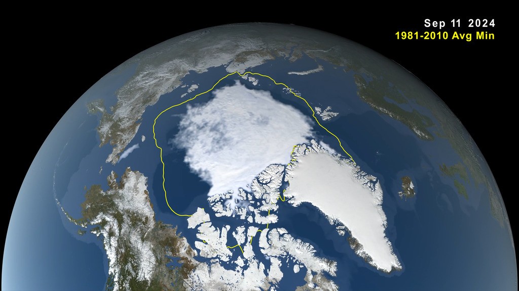
ICEsat2 DATA is at NSIDC LINK

===

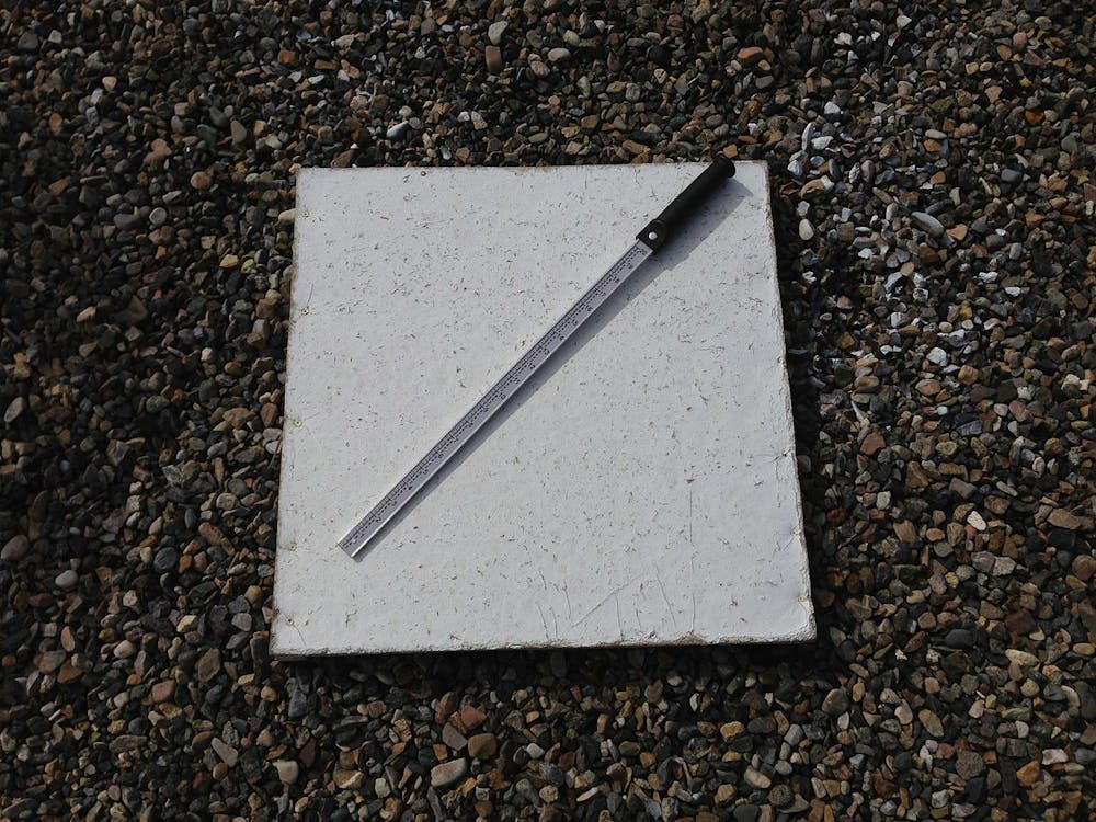
NOAA is the source ReinyDays used to show YOU how to measure Snowfall.

NOAA

How to Measure Snowfall Accurately​


Excerpt:

Measuring snowfall accurately and precisely is important but surprisingly hard sometimes. We at the National Weather Service rely heavily on volunteers and the general public to provide snowfall measurements during winter weather events. We ask that you follow the procedures below as closely as possible when measuring snowfall and then forward the report on to us. Methods for forwarding those snowfall reports on to us will follow at the bottom of the page.

LINK

===

Maybe if you stop being a JERK you wouldn't so filled with errors and ignorance?
 
Last edited:
[giggle] ... NASA doesn't study the atmosphere ... NOAA does ... how stupid can you be? ...

Feel free to vist any weather station's web site and you'll see not a single one of them list "permanent ice thickness" ... but you've never noticed that ... do you even know where to find a weather station's web site? ... see, they only list snowfall depth ... which is measured by amateurs using a ruler ... "Stick it in the ground" NOAA says, "works great" ... HAW HAW HAW HAW HAW HAW HAW HAW HAW HAW HAW HAW HAW HAW ... using NASA to dispute NOAA about the weather, that's funny ...
Have a nice laugh, now go look in the mirror and laugh at yourself.

NASA does study the atmosphere. Hell, this argument has been resolved within these threads themselves.

You are talking about people sticking rulers in their backyards to measure snow for NOAA? I do not recall anybody but you speaking about people's backyards in this OP about Arctic ice? Why is it that you are so far off topic and still talking about grandparents and rulers?

Permanent Ice Thickness. I dont recall any of my posts addressing that as well.

You are certainly a moron, sitting in your chair, eating oatmeal over your computer, blabbering about rulers you got stuck in your, where?

NASA does not study the atmosphere? I guess in your small world and your even smaller mind, NASA counts down to zero from ten, and in doing so they do not use their fingers so you have no understanding why?

Screenshot from 2022-02-02 18-14-15.png
 
Thankfully, they haven't screwed with the definition of "what is iced". It's always been 15% or more floating ice in any sector. Which MOST people dont know. Because that's a lot of open ocean in between bergs. And it's subject to MASSIVE SWINGS in total ice AREAS because that 15% of ice is there or not -- the WHOLE area goes into the iced or not iced columns.

One of the neat features of modern satellites is the ability to ESTIMATE the age of the ice from the height above the surface. There's no REAL old ice, but it gives an better idea of where the ice is BY VOLUME.


People IGNORE the weather. Got a schedule to keep and you take risks. I'm sure they got all the data they needed. Needed and HEEDED are different things. They got caught because ice is MOVABLE and shifts with the winds, currents when it's sea ice. Satellites only PASS so many times a day. And if you're 60 miles into some fiord you shouldn't have partied into -- it could HOURS to regroup and try to get out when the ice moves in.
Ice and NASA, NASA does not release the raw data from the satellites. They release, "products". The truth is somewhere in between the product and the raw data.
 
Well, YOU are the one who makes unverified incorrect opinions over and over through the thread while me and ReinyDays actually have the GALL to post data/facts with links to support what we state to help you see what we think about it then you come back like a jerk.

Apparently, my question was too hard for you to answer and why I asked you about seems to have zoomed over your head also.


I already pointed out your error "It is guess work when it comes to ice" with my reply,

"Satellites lack the resolution to see all of the ice which is why it can only be a ballpark number, but it still has some value when applied over the years consistently."

Then ReinyDays comes along to correctly point out that it sees in TWO dimensions.

"Satellites only give us 2-Dimensional pictures of what is in fact a 3-Dimensional structure ... each successive generation of GOES satellites improve our resolution of spacial positions and the hydrodynamics going on there ... but we're still only as advanced as "high, middle and low" ..."

===

Satellites provide useful data needed especially when it is applied consistently over the years but lacks the needed resolution to see very small ice cover and see water covering over ice thus not counting the ice which means some of the ice isn't being accounted for.

Do you know what the current Resolution is for measuring the ice in the arctic region?
An opinion can be nothing more and it can be a fact. My opinion is you operate with half a fucking brain and half a cup of cold noodles.

Satellites, great, post the raw data from NASA. I will save you the time, NASA does not release raw data. Thank you. What is the resolution of the raw data and how do you prove it without the raw data?

How does anyone prove anything that NASA states without the raw data.

They dont. There, I just proved beyond an, "opinion", that you are a moron thinking you were onto something beyond your insults that you began your conversation with me.

Really, I find you to be a complete moron without a brain. It is the complete moron who only has a google search and thinks their well thought out, copy and paste of google links proves they know anything about anything.

Sea Ice, all the data we have on sea ice from the beginning of time is nothing more than a speck of sand, or the size of your brain, and that is fact.

Without a link to your brain, found with google, you can not prove that fact wrong. So link to show us your are not a monkey at a keyboard.
 

Forum List

Back
Top