That messes up your theory. And you did it to yourself.LOL!!!!
The land has to get to 600 to the pole miles to start an ice age.
That's why Greenland is in ice age and Alaska is not.
Once there, give a million or two years, the ice will push way past the polar circle....
North America 3 million years ago...

 PowerPoint Presentation, free ...")
- Visual Search
- Save
- View image
More
Navigation
Install the app
How to install the app on iOS
Follow along with the video below to see how to install our site as a web app on your home screen.
Note: This feature may not be available in some browsers.
More options
Style variation
You are using an out of date browser. It may not display this or other websites correctly.
You should upgrade or use an alternative browser.
You should upgrade or use an alternative browser.
Apparently we really need a "debate" over the term ICE AGE because y'all are all wrong...
- Thread starter EMH
- Start date
Mushroom
Gold Member
When did North America move "outside of 600 miles"?
The funniest thing is that a significant number of people are not even aware we are still in an Ice Age, and have been for over 2.5 million years.
We are simply in the early stages of an interglacial between multiple glacial cycles. But the current Ice Age will likely continue for at least another 2-3+ million years until plate tectonics change the continental placement enough that they will end. That will most likely be when North and South America move apart enough that the current that used to pass between them resumes.
Mushroom
Gold Member
LGM was about 26,000 years ago.
An inch a year, much less than a mile of movement away from the pole.
Doesn't sound like enough to make such a huge change.
Maybe your claim is just idiotic?
This is the problem of junk science, and how little people actually understand about things like geology.
To put it in perspective, when the current ice age cycle started and there were massive palm trees growing in Alaska, most of North America was over 35 miles farther north. And that did not have a damned thing to do with the ice age at all.

It has nothing to do with the location of any one continent, but the current arrangement. Ask any geologist, and they will point at the clear "smoking gun" of the Isthmus of Panama rising up and cutting off the current that used to pass between the Atlantic and Pacific close to the equator.
We are in an unusual time geologically over the lifespan of the planet, because as far as we know this is the only time the planet has not had either a single ocean or multiple oceans with clear openings near the equator but two large oceans separated only at the poles.
EMH
Diamond Member
- Apr 5, 2021
- 32,917
- 19,279
- 2,788
- Thread starter
- #364
LGM was about 26,000 years ago.
An inch a year, much less than a mile of movement away from the pole.
Doesn't sound like enough to make such a huge change.
Maybe your claim is just idiotic?
You've already been refuted, you and McBullshit....
LOL!!!
This is where the climate debate is now stuck.
Every piece of land within 600 miles of a pole is in ice age, everything outside of that is not. Nobody has attempted to dispute that. It is the clear truth of Earth today.
Milankovitch Cycles, which I call McBullshit Cycles, take a very "Dennis Quaid" approach to ice ages - they are lightning fast, quick, and agile. They come and go really fast.
Since 2010, Milankovitch has replaced "North American Ice Age" with the claim that the ice on Chicago recently that was 2.5 miles thick was only 75k years old.
Really....
My side, which is...
- EMH
- Replies: 134
- Forum: Environment

EMH
Diamond Member
- Apr 5, 2021
- 32,917
- 19,279
- 2,788
- Thread starter
- #365
an interglacial
CO2 FRAUD is 100% about getting science invalids to believe planet Earth warms and cools as a whole. That conclusion was completely blown out of the water by the fact that Greenland froze while North America thawed during the past 1 million years.
The "interglacial" is part of CO2 FRAUD's attempt to mislead on that issue.
The last interglacial...
The "interglacial" is part of CO2 FRAUD's attempt to mislead on that issue.
The last interglacial...
- EMH
- Replies: 16
- Forum: Environment

EMH
Diamond Member
- Apr 5, 2021
- 32,917
- 19,279
- 2,788
- Thread starter
- #366
the current ice age cycle started and there were massive palm trees growing in Alaska
You can't make up just how stupid and easily refuted McBullshit is...
McBullshit claims Antarctica has been on the South Pole forever, it never moved at all. And, while it is on the South Pole, it has rapidly gone from ice age to tropical paradise and back over and over.... a Dennis Quaid theory for sure...
We know that Antarctica has 70 million year old dinosaur fossils, and clearly they did not live on top of 2+ mile thick ice at -60F...
We know that Antarctica has 70 million year old dinosaur fossils, and clearly they did not live on top of 2+ mile thick ice at -60F...
- EMH
- Replies: 63
- Forum: Environment


- Aug 9, 2021
- 1,769
- 1,774
- 1,938
This is the problem of junk science, and how little people actually understand about things like geology.
To put it in perspective, when the current ice age cycle started and there were massive palm trees growing in Alaska, most of North America was over 35 miles farther north. And that did not have a damned thing to do with the ice age at all.
It has nothing to do with the location of any one continent, but the current arrangement. Ask any geologist, and they will point at the clear "smoking gun" of the Isthmus of Panama rising up and cutting off the current that used to pass between the Atlantic and Pacific close to the equator.
We are in an unusual time geologically over the lifespan of the planet, because as far as we know this is the only time the planet has not had either a single ocean or multiple oceans with clear openings near the equator but two large oceans separated only at the poles.
Clinging on to hypotheses, for example "the world is flat", and then creating other new hypotheses to explain observations that refute your original hypotheses is not science. It's politics.
That is not a palm tree. That is a fern.
Mushroom
Gold Member
Clinging on to hypotheses, for example "the world is flat", and then creating other new hypotheses to explain observations that refute your original hypotheses is not science. It's politics.
That is not a palm tree. That is a fern.
No, that is a palm frond. Very clearly, that is nothing like a fern.
Toddsterpatriot
Diamond Member
You've already been refuted, you and McBullshit....
LOL!!!
This is where the climate debate is now stuck.
Every piece of land within 600 miles of a pole is in ice age, everything outside of that is not. Nobody has attempted to dispute that. It is the clear truth of Earth today.
Milankovitch Cycles, which I call McBullshit Cycles, take a very "Dennis Quaid" approach to ice ages - they are lightning fast, quick, and agile. They come and go really fast.
Since 2010, Milankovitch has replaced "North American Ice Age" with the claim that the ice on Chicago recently that was 2.5 miles thick was only 75k years old.
Really....
My side, which is...
- EMH
- Replies: 134
- Forum: Environment
Less than a mile refutes your idiotic claim.
Still looking for Southern Hemisphere data?
Silly fucktard.
EMH
Diamond Member
- Apr 5, 2021
- 32,917
- 19,279
- 2,788
- Thread starter
- #370
Less than a mile refutes your idiotic claim.
LOL!!!
Greenland is barely 1 mile thick. We have 130k years of ice core data, and that did not go halfway down...
Your side is arguing that 2.5 mile thick ice age glacier was only 77k years old....
Toddsterpatriot
Diamond Member
LOL!!!
Greenland is barely 1 mile thick. We have 130k years of ice core data, and that did not go halfway down...
Your side is arguing that 2.5 mile thick ice age glacier was only 77k years old....
Tell me again that NA moving much less than a mile is the difference between ice sheets across Illinois and no ice sheets.
DURR
Toddsterpatriot
Diamond Member
Do you deny that ice melted in the past 3 million years?
Less than a mile?
DURR
EMH
Diamond Member
- Apr 5, 2021
- 32,917
- 19,279
- 2,788
- Thread starter
- #374
Less than a mile?
DURR
durrr....
North America 3 million years ago.... durr....
The "Glacial Maximum" in the above map was originally dated at 50 million years ago, part of what was called North American Ice Age prior to 2012, when this happened..
Since then CO2 FRAUD has tried to claim "ice ages" are lightning fast, never mind ice cores completely refute that too...
This is where the climate debate is now stuck.
Every piece of land within 600 miles of a pole is in ice age, everything outside of that is not. Nobody has attempted to dispute that. It is the clear truth of Earth today.
Milankovitch Cycles, which I call McBullshit Cycles, take a very "Dennis Quaid" approach to ice ages - they are lightning fast, quick, and agile. They come and go really fast.
Since 2010, Milankovitch has replaced "North American Ice Age" with the claim that the ice on Chicago recently that was 2.5 miles thick was only 75k years old.
Really....
My side, which is...
- EMH
- Replies: 134
- Forum: Environment
Toddsterpatriot
Diamond Member
durrr....
North America 3 million years ago.... durr....
The "Glacial Maximum" in the above map was originally dated at 50 million years ago, part of what was called North American Ice Age prior to 2012, when this happened..
Since then CO2 FRAUD has tried to claim "ice ages" are lightning fast, never mind ice cores completely refute that too...
This is where the climate debate is now stuck.
Every piece of land within 600 miles of a pole is in ice age, everything outside of that is not. Nobody has attempted to dispute that. It is the clear truth of Earth today.
Milankovitch Cycles, which I call McBullshit Cycles, take a very "Dennis Quaid" approach to ice ages - they are lightning fast, quick, and agile. They come and go really fast.
Since 2010, Milankovitch has replaced "North American Ice Age" with the claim that the ice on Chicago recently that was 2.5 miles thick was only 75k years old.
Really....
My side, which is...
- EMH
- Replies: 134
- Forum: Environment
No, you stupid twaat, we're talking about the movement between the LGM ~21,000 years ago
and the retreat of the ice sheets. How far south did NA move to cause the retreat from then?
Was it less than a mile?
DURR
EMH
Diamond Member
- Apr 5, 2021
- 32,917
- 19,279
- 2,788
- Thread starter
- #377
between the LGM ~21,000 years ago
Parroting CO2 FRAUD BS as a "faux skeptic" again, you've been completely refuted already...
durr..
CO2 FRAUD is 100% about getting science invalids to believe planet Earth warms and cools as a whole. That conclusion was completely blown out of the water by the fact that Greenland froze while North America thawed during the past 1 million years.
The "interglacial" is part of CO2 FRAUD's attempt to mislead on that issue.
The last interglacial...
The "interglacial" is part of CO2 FRAUD's attempt to mislead on that issue.
The last interglacial...
- EMH
- Replies: 16
- Forum: Environment
HikerGuy83
Diamond Member
- Dec 26, 2021
- 21,897
- 17,262
- 2,288
Why have a debate when you've answered the question?What is an ICE AGE?
Most apparently still believe it is a terrifying horror movie event where Earth all at once freezes up. The data has never supported such a scenario. Since 2010, there has been a massive effort to re-write Earth climate history into a series of rapid "glaciations" and ice retreats, as if "Day After Tomorrow" movie is accurate... LOL!!! What was North American Ice Age before 2010 is now spun into a series of rapid "ice ages" where it took a mere 75k years for the "ice age" to start in Northern Canada and put 2.5 mile thick glaicers on Chicago. This is "Milankovich" cycles, which I call McBullshit, and the data and debate on North American Ice Age vs. McBullshit is here...

How old were the 2.5 mile thick glaciers covering Chicago in the past 20k-5 million years?
This is where the climate debate is now stuck. Every piece of land within 600 miles of a pole is in ice age, everything outside of that is not. Nobody has attempted to dispute that. It is the clear truth of Earth today. Milankovitch Cycles, which I call McBullshit Cycles, take a very...www.usmessageboard.com
and it isn't close. McBullshit is off by a factor of 10+ on every measure of ice age glacier available today.
The original definition of ICE AGE which is still used today was formed without any knowledge that land moves via the tectonic plates. It was thought that glaciation of South America's southern tip was the result of ice from Antarctica, in its current position, growing out over ocean and freezing up southern South America "during an ice age". Since 2010 that is now recorded, cough cough, as a rapid series of Dennis Quaid style ice ages coming and going. Neither of those are correct. As this map with sea level depth exposed shows, South America on the southern tip glaciated because 20 million or so years ago it was still attached to Antarctica, but isn't anymore and that's why it melted to just mountains today...
Antarctica itself has 70 million year old dinosaur fossils, because 70 million years ago it was not on the South Pole (and not covered with 2+ mile thick ice age glacier), but halfway to South Africa where it originated.
Rule 1 = Ice Age Glacier does not grow out over ocean, it breaks off - see Antarctica and Greenland, Titanic
Rule 2 = Ice Ages are Continent Specific Events because of Rule 1
The proof of this is the indisputable fact that Greenland froze while North America thawed. 20k years ago there was ice still in Chicago and Indiana. That is now gone. The Vikings were farming the southern tip of Greenland until the 1400s, when they were frozen off/out. For the past 20k years, Greenland froze while North America thawed. How far back that goes is in debate now, but it is a laughable debate. The data from Greenland is pretty well defined.
Greenland was unfrozen, completely unfrozen, 2 million years ago, as its northern tip was a flourishing forest....
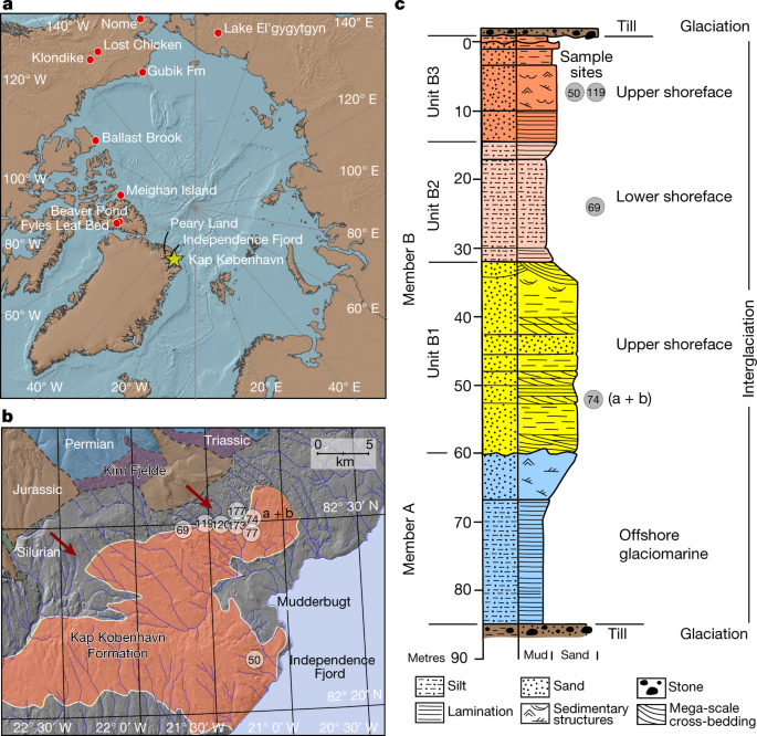
A 2-million-year-old ecosystem in Greenland uncovered by environmental DNA - Nature
Analysis of two-million-year-old ancient environmental DNA from the Kap København Formation in North Greenland shows there was an open boreal forest with diverse plant and animal species, of which several taxa have not previously been detected at the site, representing an ecosystem that has no...www.nature.com
Center of Greenland went from forest to ice age 400-800k years ago...
Ancient Greenland Was Actually Green
Greenland was once carpeted in lush forests, a new study shows.www.livescience.com
The continent specific ice age on Greenland is under 2 million years old.
North America had this for either 75k years or 30-50 million years (the latter is the sane answer)

This map was done before the data from Greenland kept rolling in, as it was assumed Greenland and NA were attached and Greenland had been frozen for a long time = NOT THE CASE according to the data above. North America was covered with ice age glacier down to Indiana. That is the debate in the first link at the top of the post, how old that ice was and how long it took to grow and melt. Clearly, it melted, and Greenland is now frozen.
North America thawed while Greenland froze. Ice Ages are continent specific (with a planetary effect) but not planetary. THAT is the DATA...
So what causes an ICE AGE?
Land moving near the poles. When land gets to within - roughly- 600 miles of a pole, as Greenland just did, the annual snowfall ceases to fully melt in the summer, and then it starts to stack. Stack for a million or 2 years = Greenland. Stack for 40+ million years = Antarctica. Ice ages like North American Ice Age end when the land moves outside of the 600 miles to a pole barrier.
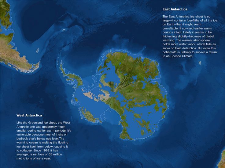
Greenland and Antarctica are ice ages. Earth Climate Change is 99% about where land is. If Earth had two polar oceans, it would have no ice (much warmer). If Earth had two polar continents, two "Antarcticas" it would have roughly twice the ice, oceans would be lower, there would be a thinner atmosphere with less humidity, and it would be colder...
Earth climate change is about ice. Ice controls sea level, temperature, atmospheric thickness, and humidity.
Ice is about where land is. 90% on Antarctica, 7% on Greenland today.
Land moves.
Not that hard.
Atmosphere, Co2 in atmosphere and Sun are not causes of climate CHANGE. Co2 does nothing. Sun is constant. What changes is where land is...
If you understand what an ice age is, it all makes sense. If you blur it and allow the Co2 fraud to define "ice age" as a Dennis Quaid movie, you are lost, and you are playing their game of debating their fudged fraud....
Or you think you have, anyway.
HikerGuy83
Diamond Member
- Dec 26, 2021
- 21,897
- 17,262
- 2,288
Why would I even try.Then try to refute it, and when you can't do that, toss cards...
I am open to all arguments on this point.
I was just suprised you called for a debate and then gave a full-blown lecture.
Similar threads
- Replies
- 62
- Views
- 1K
- Poll
- Replies
- 40
- Views
- 1K
New Topics
-

-
 Breaking: MAGA Israel first crowd supports giving US drone technology to Russia and China.
- Started by MisterBeale
- Replies: 7
-
 Trump's lowering of U.S. drug costs to kill millions in Europe
- Started by 1srelluc
- Replies: 1
-
