ScienceRocks
Democrat all the way!
- Banned
- #1
Warm, Southerly Winds Gust at Hurricane Force Over Greenland in Staggering Early Season Heatwave — Temperatures Now Hitting up to 41 Degrees (F) Above Average at Summit
The wavy, crazy Jet Stream.
Over the past few years, it’s become more and more clear that a human-forced heating of the Arctic has basically driven the Jet Stream mad. Big loops, omega blocks, and huge ridges and troughs have all become a feature of the new climate we’re experiencing. And related to these features have been a number of superstorms, severe droughts, ocean hot and cold pools, and extreme rainfall events.
Shocking extremes happening all over!
The wavy, crazy Jet Stream.
Over the past few years, it’s become more and more clear that a human-forced heating of the Arctic has basically driven the Jet Stream mad. Big loops, omega blocks, and huge ridges and troughs have all become a feature of the new climate we’re experiencing. And related to these features have been a number of superstorms, severe droughts, ocean hot and cold pools, and extreme rainfall events.
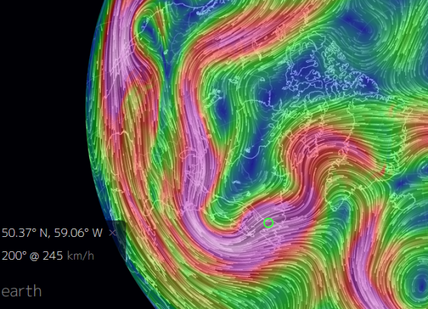
(The Jet Stream once again mangled. A strong trough shoved cool air over the US East Coast this weekend as a facing ridge prepared to hurl a bulge of extreme warmth up and over Greenland on Monday. Image source: Earth Nullschool.)
As we have seen with Sandy, the Pacific Hot Blob, the UK floods, The California Drought, The Record Alaska and Canadian Wildfire Seasons of 2015, the Russian Heatwave and Fires of 2011, the Pakistan Floods of 2011, and so, so many more extreme weather events, these new climate features present a risk of generating extraordinary or never before seen weather. Intense storms, extreme winds, and extreme cold flashes and heatwaves can all be generated as the result of such mangled weather patterns. And for much of the North Atlantic this past weekend, such abnormal conditions dominated. The US East Coast experienced a freak cold flash, the UK was pummeled by yet one more unseasonable gale, but perhaps worst of all — a head of extraordinarily warm air roared northward, riding upon gale to hurricane force winds, setting sights on Greenland.
Cool Flash for Eastern US, Extreme Heat for Greenland
This past weekend, the US weather news was all awash with comments on Winter-like conditions in April for the Northeast and Mid-Atlantic US as a deep trough tore down from the Canadian Archipelago and Hudson Bay. The trough brought with it snow flurries, freeze warnings, and rather cold conditions for April to this region of the US. Temperatures ranged from 10-20 degrees (F) below average for this area. But compared to what was setting up to happen in the ridge zone over the Atlantic, the East Coast cool spell was quite mild considering the relative extreme heat readying for a Greenland invasion.
The warm wind pulse began in the North Atlantic in a tropical region near 26 North, 55 West. This warm air flooded in train over thousands of miles of open ocean. Running northward, it roared along the back of a high pressure system centered over the Mid Atlantic Ridge and in front of two strong lows — one centered near Newfoundland and a second over southwestern Baffin Bay.
In places, the pressure gradient between the lows and highs was so tightly packed that the northward flowing airs hit hurricane force. Off the southwest tip of Greenland, winds consistently achieved hurricane force gusts. And these winds flowed on northward, bringing with them a surge of above freezing temperatures to much of Baffin Bay and a large section of Western Greenland.
By 10:00 UTC, Monday, April 11th — Thule, on the Northwest Coast of Greenland near the Nares Strait was experiencing sustained southerly winds along the northern edge of this warm air pulse at 45 mph with gusts hitting a hurricane force 75 mph. Temperatures for Thule by that time had hit 34 degrees (F) or about 32 degrees (F ) above average.
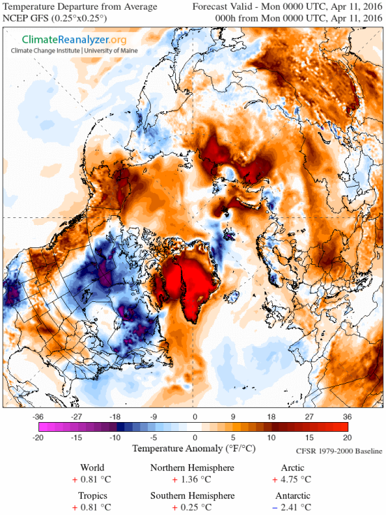
(Extreme Arctic heat strikes Greenland on April 11, 2016. There readings for a large area hit a range 36 degrees Fahrenheit or more above average for a large region over Baffin Bay and Greenland. This extreme pulse of unseasonable warm air contributed to overall temperature departures of +4.75 C (8.55 F) above average for the Arctic. A very high departure for this region of the world at this time of year and an extension to a period of record Arctic warmth in 2016. Image source: Climate Reanalyzer.)
Further south, Nuuk — near the rapidly destabilizing Jacobshavn Glacier — was experiencing 45 F readings (or about 20 F above average) coordinate with strong southerly winds. Yet further south, in Kangerlussuaq near the southwest coast of Greenland, temperatures spiked to 61 F — or 36 F above the average April 11 reading of 25 F.
Perhaps more remarkable and disturbing were the predicted extreme readings at Summit Greenland — expected to hit 21 degrees Fahrenheit on Monday or about 41 degrees (F) above a typical daily high of -20 (F) for this time of year. It’s worth noting that in July average high temperatures for Summit Greenland usually range near 12 degrees (F). So current expected highs for April 11, 2016 are nearly 10 degrees warmer than a normal July day. By comparison, if such an extreme high temperature departure were to have occurred in my hometown of Gaithersburg, MD on the same date (April 11th), readings would have exceeded a remarkable 106 Degrees Fahrenheit.
Year of Record Arctic Warmth Continues
The recent warm wind outbreak over Greenland is but one more odd event in a year of extreme warmth for the Arctic. Warm wind invasions over the North Atlantic, Barents, Baffin Bay, Greenland Sea, Western Europe, Alaska, Western Canada, the Barents, and sections of Central Asia have been a persistent feature throughout both Winter and Spring. Meanwhile, consistent temperature spikes to near freezing or above freezing over the Arctic Ocean and related waters have contributed to Arctic sea ice hitting new seasonal lows.
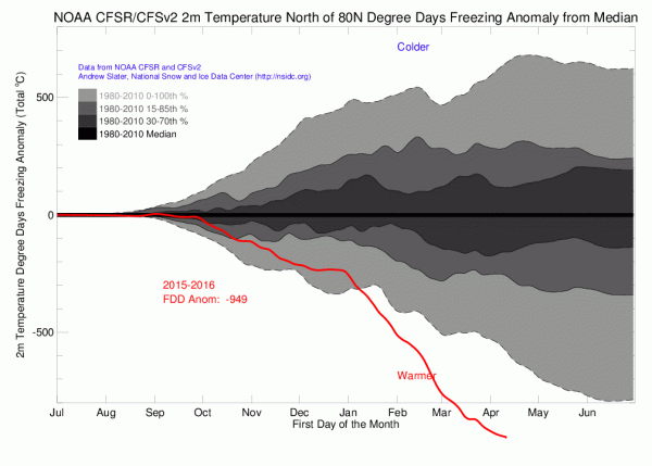
(Arctic heat has been literally off-the charts for the region above 80 degrees North during 2016. This area has now experienced nearly 1,000 fewer freezing degree days than during a typical year of the already warmer than normal 1980-2010 period. Extreme Arctic warmth of this kind has negative impacts both to the health of Arctic sea ice and to that of the various glacier systems in Greenland, Svalbard and Northern Canada. Image source: NOAA/CFSv2/CFSR.)
Overall, the Arctic has experienced unprecedented warmth for 2016. In reference to this fact, NOAA measures recording freezing degree days indicate that both the Arctic and the High Arctic above 80 degrees North Latitude are experiencing their warmest year ever recorded. These new extreme high temperatures are achieving an extraordinary departure above previous temperature measures and are a feature of the highest anomalies occurring over any portion of a record warm world. In other words, if you were to look for the region of the world that’s being hit hardest by a human-forced warming spurred on by rampant fossil fuel burning, the Arctic would light up like a fireworks display on the 4th of July.
Tropical heat, in the form of a record El Nino generated warmth, has tended to transfer pole-ward in the Northern Hemisphere during 2016 due to various weaknesses in the Jet Stream. A primary region for this transfer has occurred over the North Atlantic and Europe with secondary transfer zones over the Eastern Pacific, Western North America, and over a shifting zone throughout Northern Asia.
An extraordinary polar amplification of this kind — one that includes Equator-to-Pole heat transfers — risks hitting or increasing the intensity of a number of harmful climate tipping points. These include the amplifying feedbacks of increasing rates of sea ice melt and Arctic carbon store response. In addition, extreme warmth over Greenland risks further glacial destabilization, increasing rates of sea level rise, and increasing weather instability in the North Atlantic.
Shocking extremes happening all over!

