Antarctica undergoing severe and long-lasting heat wave

What caused the Glacier Bay glacier to recede 60 miles in 90 years - during the 1800’s.
Primarily the fact that it only formed due to the Little Ice Age. As that ended, the glacier melted. As global warming took temperatures even higher, the glacier receded tens of miles further up the valley.
 
Are all glaciers the same height? Why?


A glacier like those covering Greenland and Antarctica is a stack of years and years of accumulated snow/frost. That is why we are able to extract ice cores, because each layer in the ice core is data from a specific year. That is why we claim to have 800k years of ice core data from Antarctica. Since Antarctica is the only place on Earth where glaciers are 2.5 miles thick, we can use the data from Antarctica to extrapolate how old the 2.5 mile thick glacier covering Chicago was. Clearly, if you do not even go halfway down Antarctic ice, and you get 800k years of ice core data, the Antarctic 2.5 mile thick glacier is way older than just 800k years.

Your McBULLSHIT on Chicago and North American Ice Age claims the 2.5 mile thick glacier on Chicago during the past 5 million years was somehow only 75k years old.

In comparison, the thickest part of Greenland's ice sheet is slightly higher than a mile thick, and we got 130k years of ice core data from that, again OLDER than McBULLSHIT's claim of the age of the ice on Chicago, while being MORE THAN A MILE SHORTER.... and again that 130k years of ice core data did not get close to the bottom of the glacier....


McBULLSHIT's claim that 2.5 mile thick ice on Chicago was less than 75k years old is OFF BY WAY MORE THAN A FACTOR OF 10 GIVEN THE DATA WE ACTUALLY HAVE TODAY, REAL DATA, not McBULLSHIT "estimates..."
 
Primarily the fact that it only formed due to the Little Ice Age. As that ended, the glacier melted. As global warming took temperatures even higher, the glacier receded tens of miles further up the valley.


Complete bullshit.

Tectonic direction of NA = SW....

Glaciers grow on land that is approaching the nearest pole. Glaciers melt on land moving away from the nearest pole.

For sea ice, there are undersea volcanoes that radically alter sea ice....

2007, for example...


A glacier like those covering Greenland and Antarctica is a stack of years and years of accumulated snow/frost. That is why we are able to extract ice cores, because each layer in the ice core is data from a specific year. That is why we claim to have 800k years of ice core data from Antarctica. Since Antarctica is the only place on Earth where glaciers are 2.5 miles thick, we can use the data from Antarctica to extrapolate how old the 2.5 mile thick glacier covering Chicago was. Clearly, if you do not even go halfway down Antarctic ice, and you get 800k years of ice core data, the Antarctic 2.5 mile thick glacier is way older than just 800k years.

Your McBULLSHIT on Chicago and North American Ice Age claims the 2.5 mile thick glacier on Chicago during the past 5 million years was somehow only 75k years old.

In comparison, the thickest part of Greenland's ice sheet is slightly higher than a mile thick, and we got 130k years of ice core data from that, again OLDER than McBULLSHIT's claim of the age of the ice on Chicago, while being MORE THAN A MILE SHORTER.... and again that 130k years of ice core data did not get close to the bottom of the glacier....


McBULLSHIT's claim that 2.5 mile thick ice on Chicago was less than 75k years old is OFF BY WAY MORE THAN A FACTOR OF 10 GIVEN THE DATA WE ACTUALLY HAVE TODAY, REAL DATA, not McBULLSHIT "estimates..."

That's a yes?
All glaciers are the same height?
 
Complete bullshit.

Tectonic direction of NA = SW....

Glaciers grow on land that is approaching the nearest pole. Glaciers melt on land moving away from the nearest pole.

For sea ice, there are undersea volcanoes that radically alter sea ice....

2007, for example...


Glaciers grow on land that is approaching the nearest pole. Glaciers melt on land moving away from the nearest pole.

Nice!

Show the progress of North America over the last 50 million years,
approaching and moving away from the pole.
 
That's a yes?
All glaciers are the same height?


MORE THAN A MILE SHORTER....


You are a sick Zionist Fascist Liar and Traitor who cheered when your investments in gold, oil, the long bond, and defense stocks started rising rapidly after 911.

And you voted for Biden not Trump.
 
Glaciers grow on land that is approaching the nearest pole. Glaciers melt on land moving away from the nearest pole.

Nice!

Show the progress of North America over the last 50 million years,
approaching and moving away from the pole.


Greenland moving NW, NA moving SW, all on the same vector on a sphere....

Greenland is roughly 50 million years behind NA given current tectonic velocity...


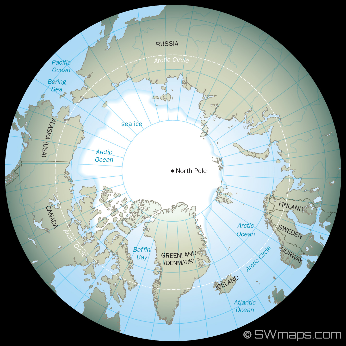
Arctic and North Pole Map - SWmaps.comArctic and North Pole Map - SWmaps.com


Search inside image

Arctic and North Pole Map - SWmaps.com

Visit
https://swmaps.com/arctic-and-north-pole-map/


motion vector dictated by angle of fault at center bottom of Atlantic...

this one...


Atlantic Ocean Floor MapAtlantic Ocean Floor Map


Search inside image

Atlantic Ocean Floor Map

Visit
 
Complete bullshit.

Tectonic direction of NA = SW....

Glaciers grow on land that is approaching the nearest pole. Glaciers melt on land moving away from the nearest pole.

For sea ice, there are undersea volcanoes that radically alter sea ice....

2007, for example...


Between meetings with the Young Nazis of America are you perhaps suggesting that Glacier Bay's rapid growth and loss of its glacier was due to tectonic movement? Has it ever occurred to you that the world might be a little more complicated than you think it is?
 
Last edited:
Between meetings with the Young Nazis of America are you perhaps suggesting that Glacier Bay's rapid growth and loss of its glacier is due to tectonic movement?


Given that the Co2 FRAUD had bilked America for tens of trillions of dollars, it is logical to assume that some of that $$$ goes to creating "Global Warming talking points" like by testing microwave weapons on one specific piece of ice....

Fact is, you do not have ONE SINGLE PHOTO of "Ocean Rise" and that is because THERE IS NO ONGOING NET ICE MELT and Surface Air Pressure chart proves it.
Glacier Bay was the target of test of microwave weapons? Holy fuckstick. Not Jewish space lasers? Jewish microwave weapons? Maybe the ISS left the microwave door open on whilst reheating their rugelach. Einstein huh...

I can give you a link to a dissertation that estimates the ice mass loss at Glacier Bay. Perhaps you could use your Supra-Einstein intellect to calculate the amount of power it would have required to melt that ice over that time span with microwaves and then give us a few educated guesses as to where it came from.

 
Last edited:
MORE THAN A MILE SHORTER....


You are a sick Zionist Fascist Liar and Traitor who cheered when your investments in gold, oil, the long bond, and defense stocks started rising rapidly after 911.

And you voted for Biden not Trump.

Glaciers aren't all the same height?
 
Greenland moving NW, NA moving SW, all on the same vector on a sphere....

Greenland is roughly 50 million years behind NA given current tectonic velocity...


Arctic and North Pole Map - SWmaps.comArctic and North Pole Map - SWmaps.com


Search inside image

Arctic and North Pole Map - SWmaps.com

Visit
https://swmaps.com/arctic-and-north-pole-map/


motion vector dictated by angle of fault at center bottom of Atlantic...

this one...


Atlantic Ocean Floor MapAtlantic Ocean Floor Map


Search inside image

Atlantic Ocean Floor Map

Visit

No, stupid, show where NA was 50 million years ago, when you said Chicago was
under a glacier. Show me how close it was to the pole.

Now, just for fun, show where it was 49 million years ago, 48 million years ago etc.

Then, 50,000 years ago, when it was still under ice. Finally, 20,000 years ago, when the ice was gone.
 
Glacier Bay was the target of test of microwave weapons? Holy fuckstick. Not Jewish space lasers? Jewish microwave weapons? Maybe the ISS left the microwave door open on whilst reheating their rugelach. Einstein huh...

I can give you a link to a dissertation that estimates the ice mass loss at Glacier Bay. Perhaps you could use your Supra-Einstein intellect to calculate the amount of power it would have required to melt that ice over that time span with microwaves and then give us a few educated guesses as to where it came from.


That's a big yawn.

Your theory is global warming, as in GLOBAL, not Glacier Bay on a continent moving AWAY FROM THE NEAREST POLE....

Globally, this is the score...

NO WARMING in the ATMOSPHERE
NO WARMING in the OCEANS
NO ONGOING NET ICE MELT
NO BREAKOUT IN CANE ACTIVITY
NO OCEAN RISE
 
No, stupid, show where NA was 50 million years ago, when you said Chicago was
under a glacier


Only in the world of Co2 FRAUD McBULLSHIT is there an instantaneous covering of a continent with ice. In reality, the speed is GLACIAL, and it likely took a full million years once North American Ice Age started 30-50 million years ago for that ice to reach Chicago. Once it reached Chicago, it took 20+ million years to get over 2 miles high.


Show me how close it was to the pole

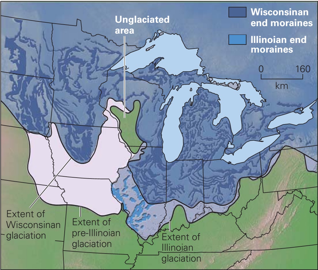
Don't have sophisticated graphics. The arc of tectonic motion and the vector of the fault are already posted. The top of North America looked quite different 50 million years ago, before being scraped out by glaciers for tens of millions of years. One artist did this, but it has NA and Greenland attached, which wasn't the case since NA was buried under glacier 2 million years ago and Greenland was completely green.

R.662f919eb8254b9b9115108f266c13b3


The Pleistocene Ice Age ~ Learning Geology


Then, 50,000 years ago, when it was still under ice. Finally, 20,000 years ago, when the ice was gone.


That is a confession that during the past 50k years, GREENLAND FROZE WHILE NA THAWED.
 
Only in the world of Co2 FRAUD McBULLSHIT is there an instantaneous covering of a continent with ice. In reality, the speed is GLACIAL, and it likely took a full million years once North American Ice Age started 30-50 million years ago for that ice to reach Chicago. Once it reached Chicago, it took 20+ million years to get over 2 miles high.


Don't have sophisticated graphics. The arc of tectonic motion and the vector of the fault are already posted. The top of North America looked quite different 50 million years ago, before being scraped out by glaciers for tens of millions of years. One artist did this, but it has NA and Greenland attached, which wasn't the case since NA was buried under glacier 2 million years ago and Greenland was completely green.

R.662f919eb8254b9b9115108f266c13b3


The Pleistocene Ice Age ~ Learning Geology


Don't have sophisticated graphics.

Then just give me the numbers.
How many miles away was NA 50 million years ago?
How many miles away and when did the 50-million-year glacier melt?
 
That is a confession that during the past 50k years, GREENLAND FROZE WHILE NA THAWED.

Show me that Greenland was thawed 50,000 years ago.
While it was further north than frozen NA.
Or was it further south?
 
How many miles away was NA 50 million years ago?

More precisely, between 30-50 million years ago, the top of North America crossed over the 600 miles to the Pole threshold and hence started to stack ice. 50 million was the accepted number prior to McBullshit.


when did the 50-million-year glacier melt?


Melting 5+ million cubic miles of ice takes some time. Given the map of Northern Canada, what is underwater today was filled with ice 5 million years ago. Ellesmere Island is still within 600 miles of the Pole and hence is still in Ice Age, which is why it has 0.3% of Earth ice now. What officially shut off the North American Ice Age is when Ellesmere Island's current surrounding water changed from ice to water. We can only guess when and why, but clearly there are undersea volcanoes in the Arctic Ocean. My guess is that happened in the past 1- 5 million years. so call it 3 million years ago, and once it happened, it shut off North American Ice Age from the 600 miles to the Pole threshold, and hence NAIA ceased to grow and started to melt. Or more precisely, the ice coming south from the top of Northern Canada ceased, leaving a huge ice sheet with no "reinforcements."
 
Show me that Greenland was thawed 50,000 years ago.
While it was further north than frozen NA.
Or was it further south?


You would be arguing that Greenland was "frozen" way further south than it was 2 million years ago, the last time it was green.

Just rewind the fault at the center bottom of the Atlantic.


A map of the Atlantic Ocean floor published in 1968 based on a large... |  Download Scientific DiagramA map of the Atlantic Ocean floor published in 1968 based on a large... |  Download Scientific Diagram


Search inside image

https://www.google.com/url?sa=i&url...ved=0CBIQjhxqFwoTCOCSvIqV5IcDFQAAAAAdAAAAABAD

Search inside image

https://www.google.com/url?sa=i&url...ved=0CBIQjhxqFwoTCOCSvIqV5IcDFQAAAAAdAAAAABAD
 

Attachments

  • 1723077831966.webp
    1723077831966.webp
    17 KB · Views: 9
Show me that Greenland was thawed 50,000 years ago.


Sorry, assumed you meant 50 mil.

50k years ago Greenland's ice age had yet to cover the southern peninsula, likely held up by the mountain range just north of the peninsula.

We have good data on Greenland.

Totally green 2 million years ago at the top.


Middle went from forest to ice age 400-800k years ago...


The Vikings farmed the Southern Tip aka peninsula until the 1400 when they were frozen out by the advancing ice age.
 
Back
Top Bottom