P F Tinmore,
et al,
Good Morning!
You post a lot of stuff to smokescreen the issue. But your stuff does not prove your point.
(COMMENT)
Well, actually it does answer the question about the who, what, where, when, and why, the borders came about.
Article 95 of Part III - Section VII (Syria, Mesopotamia, Palestine) in the
Treaty of Sevres says: "the administration of Palestine, within such boundaries as may be determined by the Principal Allied Powers." What I presented in
Posting #99 directly answers the basic interrogatives on the boundaries that were set by two of the Allied Powers of San Remo.
If they were hammering out the borders between the mandates, what would be the point of mentioning Lebanon, Syria, Palestine, and Mesopotamia? Actually they were setting the international borders of Palestine and Lebanon, and Palestine and Syria.
(COMMENT)
Because that were the names of the three Class "A" Mandates handed down by the League of Nations:
(COMMENT)
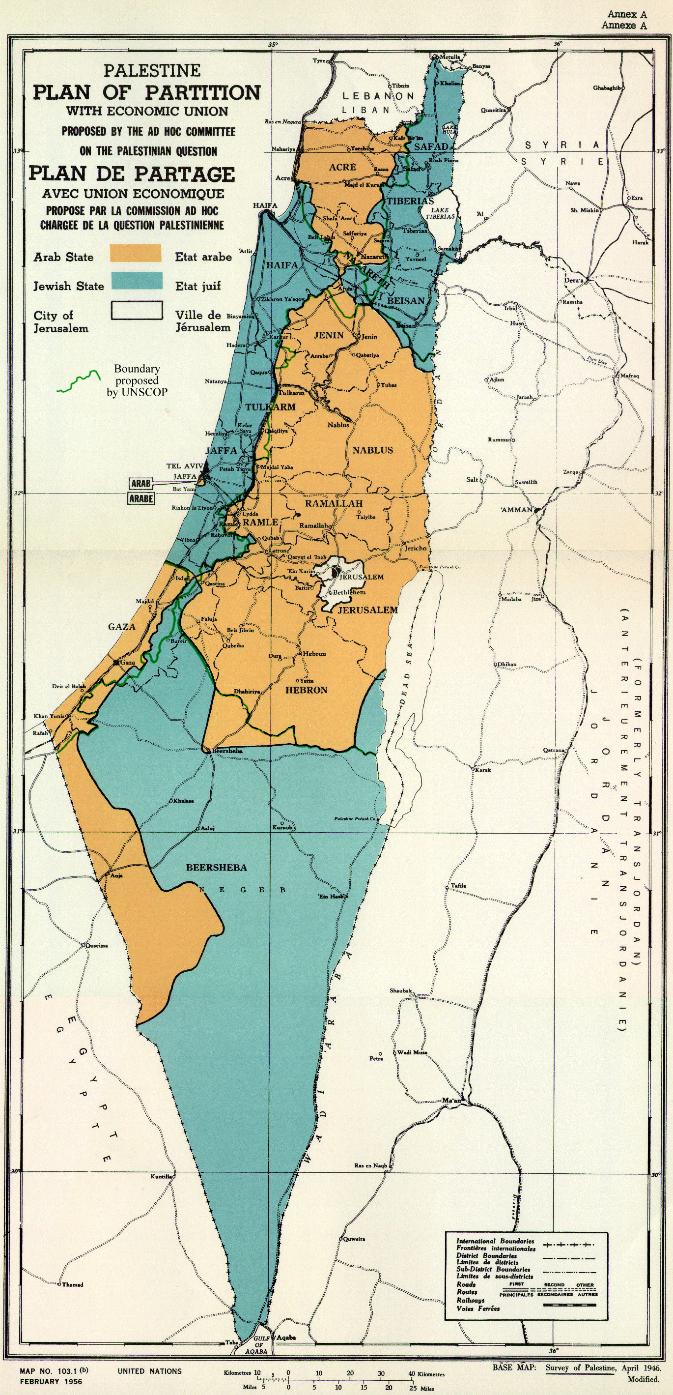
Yes, our friend "toastman" is very much correct. It is the standard 1:100,000 Scale Map [UN 103.1(b)] traditionally used when referring to the territory. It is a 1946 modified and improved version of Map #8 (British War Office # OR 924) to the
1937 Peel Commission Survey (and is annotated so). The one you Posted happens to be the UN Special Commission on Palestine (UNSCOP) and initially annotated to be used as the base map for
Annex A to Resolution 181 (II) of the General Assembly. It's uses of the term "Palestine" is in accordance with the Paragraph 1, Part I,
Palestinian Order in Council wherein it says: "The limits of this Order are the territories to which the
Mandate for Palestine applies, hereinafter described as Palestine."
Show me where any international law states that foreigners can go to another country with guns and claim the right to self determination.
(COMMENT)
FIRST!
This is a bit absurd. The Jewish Immigration into the territory under Mandate was not at gun point by Jews, it was done in accordance with the Mandate for Palestine passed down by the League of Nations and the Allied Powers.
The inference that the Jews, in the initial immigration came as some armed force, is totally inaccurate.
EXCERPTS: Mandate for Palestine said:
Article 4
An appropriate Jewish agency shall be recognised as a public body for the purpose of advising and co-operating with the Administration of Palestine in such economic, social and other matters as may affect the establishment of the Jewish national home and the interests of the Jewish population in Palestine, and, subject always to the control of the Administration, to assist and take part in the development of the country.
The Zionist Organisation, so long as its organisation and constitution are in the opinion of the Mandatory appropriate, shall be recognised as such agency. It shall take steps in consultation with His Britannic Majesty's Government to secure the co-operation of all Jews who are willing to assist in the establishment of the Jewish national home.
Article 6
The Administration of Palestine, while ensuring that the rights and position of other sections of the population are not prejudiced, shall facilitate Jewish immigration under suitable conditions and shall encourage, in co-operation with the Jewish agency referred to in Article 4, close settlement by Jews on the land, including State lands and waste lands not required for public purposes.
SOURCE: C. 529. M. 314. 1922. VI.
Second!
In the Preamble to the
United Nations Declaration on the Rights of Indigenous Peoples clearly states: "Bearing in mind that nothing in this Declaration may be used to deny
any peoples their right to self-determination, exercised in conformity with international law." (Remember that the Mandate for Palestine was (at that time) the legal authority.)
(BACK TO THE QUESTION)
Again, what authority do you use to show the International Borders of Palestine?
Most Respectfully,
R