Satellite Down! No Sea Ice Measurements, says NSIDC

elektra

Platinum Member
Dec 1, 2013
28,789
13,945
1,065
Jewitt City, Connecticut
Wow, unbelievable, a NASA satellite has a broken sensor and it is unreported here, and pretty much everywhere else. All the data for April is now garbage, but I wonder, if the data from all those "record" months is not irrelevant or false. After reporting the doom and gloom that the Sea Ice Extent is a record low, it would be too embarrassing to retract that story now. Nice job "Scientists"!
ssmi_dmsp.jpg

Sensor on F-17 experiencing difficulties, sea ice time series temporarily suspended | Arctic Sea Ice News and Analysis
Sensor on F-17 experiencing difficulties, sea ice time series temporarily suspended

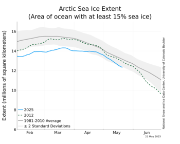
NSIDC has suspended daily sea ice extent updates until further notice, due to issues with the satellite data used to produce these images. The vertically polarized 37 GHz channel (37V) of the Special Sensor Microwave Imager and Sounder (SSMIS) on the Defense Meteorological Satellite Program (DMSP) F-17 satellite that provides passive microwave brightness temperatures is providing spurious data. The 37V channel is one of the inputs to the sea ice retrieval algorithms, so this is resulting in erroneous estimates of sea ice concentration and extent. The problem was initially seen in data for April 5 and all data since then are unreliable, so we have chosen to remove all of April from NSIDC’s archive.
 
Wow, unbelievable, a NASA satellite has a broken sensor and it is unreported here, and pretty much everywhere else. All the data for April is now garbage, but I wonder, if the data from all those "record" months is not irrelevant or false. After reporting the doom and gloom that the Sea Ice Extent is a record low, it would be too embarrassing to retract that story now. Nice job "Scientists"!
View attachment 71935
Sensor on F-17 experiencing difficulties, sea ice time series temporarily suspended | Arctic Sea Ice News and Analysis
Sensor on F-17 experiencing difficulties, sea ice time series temporarily suspended

NSIDC has suspended daily sea ice extent updates until further notice, due to issues with the satellite data used to produce these images. The vertically polarized 37 GHz channel (37V) of the Special Sensor Microwave Imager and Sounder (SSMIS) on the Defense Meteorological Satellite Program (DMSP) F-17 satellite that provides passive microwave brightness temperatures is providing spurious data. The 37V channel is one of the inputs to the sea ice retrieval algorithms, so this is resulting in erroneous estimates of sea ice concentration and extent. The problem was initially seen in data for April 5 and all data since then are unreliable, so we have chosen to remove all of April from NSIDC’s archive.
Unreported here?!? There are at leasr two other threads discussing this. Climb out from under that rock
 
Unbelievable? A machine fails, and you find that unbelievable? Talk about dumb flap yap points.

But we are not the only ones with satellites watching the arctic ice. So, as soon as the calibration of their data to our equivelant data is done, we will get the ice figures again.
 
  • Thanks
Reactions: PK1
Spencer and Braswell's 2011 junk science is "new"? Yeah, you go with that. That paper was so bad, the journal editor literally resigned in disgrace. Pickings must be really slim in Denierstan, if that's what they're resorting to.

Meanwhile, back to the topic that deniers are now running so fast from, the sea ice satellites. Essentially, there were only two good satellites left, and one failed. The remaining good instrument is the AMSR-2 on the Japanese GCOM-W satellite.

More Grumbine Science: 2016 Tough on Sea Ice Satellites

Being that calibration differs between satellites, you can't just simply swap to measurements from a different satellite, not if you want the output to be honest. Doing so would cause a big jump in some direction, one that doesn't represent the real world.
 
They knew this would happen, it was stated years ago. The question is, how do we know the data from previous months is accurate?

Actual observations in the regions show the number has been way to low for over 9 months. The low reports were heralded by the alarmists as proof of CAGW.. The actual observations by on the ground meteorologists shows the numbers were artificially way to low.

A couple of reports by other agencies with operating satellites say were inside the 2 standard deviations and have been for over a year in concurrence with one the ground measurements..
 
Wow, unbelievable, a NASA satellite has a broken sensor and it is unreported here, and pretty much everywhere else. All the data for April is now garbage, but I wonder, if the data from all those "record" months is not irrelevant or false. After reporting the doom and gloom that the Sea Ice Extent is a record low, it would be too embarrassing to retract that story now. Nice job "Scientists"!
View attachment 71935
Sensor on F-17 experiencing difficulties, sea ice time series temporarily suspended | Arctic Sea Ice News and Analysis
Sensor on F-17 experiencing difficulties, sea ice time series temporarily suspended

NSIDC has suspended daily sea ice extent updates until further notice, due to issues with the satellite data used to produce these images. The vertically polarized 37 GHz channel (37V) of the Special Sensor Microwave Imager and Sounder (SSMIS) on the Defense Meteorological Satellite Program (DMSP) F-17 satellite that provides passive microwave brightness temperatures is providing spurious data. The 37V channel is one of the inputs to the sea ice retrieval algorithms, so this is resulting in erroneous estimates of sea ice concentration and extent. The problem was initially seen in data for April 5 and all data since then are unreliable, so we have chosen to remove all of April from NSIDC’s archive.
Unreported here?!? There are at leasr two other threads discussing this. Climb out from under that rock
I see no thread that reported the sensor failing, if some post discussed this, I have not seen it. So, being that there is no thread discussing this, it is unreported.
 
Unbelievable? A machine fails, and you find that unbelievable? Talk about dumb flap yap points.

But we are not the only ones with satellites watching the arctic ice. So, as soon as the calibration of their data to our equivelant data is done, we will get the ice figures again.
Just like when one fails to link, they are a liar, when one fails to "quote", they are a liar. Old Crock, I never posted what you state, you may just be unable to comprehend English, it is "not as easy as pie".
 
Small differences in the details make for large changes in the trend, I am sure there was a small difference in the data from the record setting past few months. I bet it is time to revise that opinion, I state that there was no record set in regards to the sea ice being at a minimum.

All we have to go on is an old faulty satellite, hardly solid science.

More Grumbine Science: 2016 Tough on Sea Ice Satellites

If you're trying to study climate, as many centers are, small differences in the details of what the sensor sees can make for large changes in the trends you'd fine in a sea ice analysis. So you have to work, hard, to make sure that the analysis you get from AMSR2, for instance, is consistent with what you were getting from F-17 for the last several years. This is what the NSIDC is likely doing right now. Since my professional concern is more weather, I don't have quite the issue. But I still need data to work with, and losing perhaps 2 potential backups is not cheery. Losing half the data from one of the satellites I already use is also hot happy. And, although my quality control procedures (or those which are cutting my supply in half) are doing ok for now, it's uncomfortable to know that my data supply is even less good than it used to be.
 
You can see here exactly where the satellite started sending erroneous data.

Northern Hemisphere Sea Ice Area

Note that the erroneous data showed an increase, rather than, a decrease in the ice.
Old Crock, the Satellite Sensor just broke! Like a few days ago, not years! Try and keep up, it is, "as easy as pie".

The sensors degrade in minute fashion over time when exposed to Gama radiation. This is why the last few months are extremely suspect and why just before total failure they again operate normally for a brief period before crashing. Its this brief restoration that gives us the hint that it just died.
 
Knowing they are degrading, I wonder how the "scientists" may be biased when they physically hand color in the grids to indicate where they believe there is ice or no ice. The process is very subjective, and given how a small difference in the details can amplify the results, all is suspect.
 

Forum List

Back
Top