New Weather Satellite is up and running;
WOOOOOHOOOOOO..
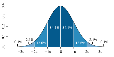
At long last calibrations are now completed with the new polar orbiting satellite and the last years data has been remaksed with the corrected algorithm.. Sea Ice bounces back into 2STD ranges and right where empirical observations say it should be.. Alarmists will not be happy!
Finally some decent data that reflects reality...
Hard for me to imagine what happened here. Because SIE is all visual band data. Maybe still MULTI-BAND, but still literally just pictures. How can a camera be SOOOO bad as to not get the contrast between ice and open water? Seems to me there is more to this story. Maybe screwing up on cloud cover? The Russians?
Its actually taken from the LWIR bands where water, being a grey body, emits more than actual hard ice which is essentially emitting as a black body. Its the percentages of difference that had to be determined along with cloud cover affect. We haven't used photos for 15 years or so and then only to verify a regions calculations.
The secondary sounder system uses High Frequency Radio Waves and looks at the return similar to how radar works. When you use several different frequencies, which only resonate with specific materials, you can isolate ice pack from open water with very good accuracy. Ice will generate a hard return while water will generate a soft (changing shape) return.
Once your base lines are set, periodic checks are necessary to verify integrity.
I'm just happy, after three years, we have a functioning polar orbiting satellite.. Both poles are at or above the 2STD's.