Billy_Bob
Diamond Member
Snow in Utah yesterday and Snow in Wyoming today down to 5500 feet... Welcome Winter.. Just 8 weeks early..
Follow along with the video below to see how to install our site as a web app on your home screen.
Note: This feature may not be available in some browsers.
View attachment 278664
Snow in Utah yesterday and Snow in Wyoming today down to 5500 feet... Welcome Winter.. Just 8 weeks early..


I ordered up 200' of new heat tapes and pipe warming blankets. Got to winterize this next week and get things closed up. Were expecting 20 deg temps late next week.. The animals all say its time. Even Canadian Geese are migrating 8 weeks early... Two days in a row seeing massive flocks going south now.View attachment 278664
Snow in Utah yesterday and Snow in Wyoming today down to 5500 feet... Welcome Winter.. Just 8 weeks early..
WTF??!!
Ghey........Im dreading October here in New York. In recent years, its cold by the end of the first week in October........it blows. Last year, Thanksgiving Day was below zero with the wind chill.....could have kept the turkey outside to save freezer space. We wore hoodies into early June. And JC and I traded stories of frozen stuff all winter......he had it worse than me and I had my nut sack warmers at the ready for 8 months. What a load of shit........meanwhile the DUMS still talking about this "crisis".


Moron...Just when you thought it was gone, there's near Record Breaking Heat on the way
by Josh Knight/StormWatch7 Meteorologist
Tuesday, September 10th 2019[/b]
WASHINGTON (ABC7) — StormWatch7 is tracking temperatures that will soar back into the mid-90s for the middle of this week! With the humidity on the way, it will feel even hotter.
Today, the bulk of the heat is just off to our west and southwest, but it is on the way!
Heat just down to the south and west of our area today will be building in Wednesday and Thursday
By Wednesday afternoon, many of us, especially in the I-95 corridor, could see triple-digit feels like temperatures.
Wednesday DMV peak heat index
Thursday will feel very similar with the same air mass in place, but this is a short-lived blast of heat (thank goodness).
Feels like compared to temperature the next three days
`
HIGH PRESSURE is in place in a SMALL REGION while the rest of the nation and Northern Hemisphere is unseasonably cold...
Your an IDIOT who conflates a localized event with what is going on throughout the hemisphere when the empirical evidence shows your warm area is an ANOMALY compared to the rest of the NH.
This thread was started by the Section CLOWN and is 95% FULL of Daily and local WEATHER bumped for Years by it.He isn't conflating anything...he is just repeating what he was told to say by another idiot who conflates localized events with what is going on throughout the hemisphere..


‘In for a roasting’: Australia ‘on brink’ of ‘apocalyptic’ conditions
Something strange is happening in the air above Antarctica that hasn’t happened since 1992 — and it has dire consequences for Australia.
Jamie Seidel
news.com.au SEPTEMBER 11, 2019
New footage has emerged from inside the Peregian Beach disaster zone in Queensland, revealing the extent of the crisis.
The Arctic is on fire. Now, Antarctica is suddenly experiencing a heatwave. And that means a looming rainfall apocalypse for Australia.
According to a recent report by senior researchers from the Australian Bureau of Meteorology, we’re in for higher than normal spring temperatures. And less rain.
It’s all because of record warm temperatures in the air swirling above Antarctica.
It’s producing a domino effect.
The stratospheric “polar vortex” has been disrupted. It could even reverse direction.
It’s pushing stormy Southern Ocean wind streams over Tasmania, New Zealand’s South Island and South America’s Patagonia. This is away from its regular route over the Australian mainland.
And that means NSW and southern Queensland — already in parts devastated by bushfires so early in the season — are set to face worsening conditions and an even more catastrophic bushfire season.
SUDDEN STRATOSPHERIC WARMING
“The warming began in the last week of August when temperatures in the stratosphere high above the South Pole began rapidly heating,” the article published in The Conversation reads. Four senior Bureau of Meteorology forecasters compiled it.
“Thanks to improvements in modelling and the Bureau’s new supercomputer, these types of events can be forecast better than ever before.”
It foresees a looming stronger-than-usual melt of sea ice.
It foresees a shift in the typical wind temperatures and patterns coming off the Antarctic continent.
“In the coming weeks the warming is forecast to intensify, and its effects will extend downward to earth’s surface, affecting much of eastern Australia over the coming months,” the forecasters warn.
It is likely to be the most severe Antarctic warming event on record.
Have a nice page.
`

LOL‘In for a Roasting’: Australia ‘on brink’ of ‘Apocalyptic’ conditions
Something strange is happening in the air above Antarctica that hasn’t happened since 1992 — and it has dire consequences for Australia.
Jamie Seidel
news.com.au SEPTEMBER 11, 2019
‘In for a roasting’: Australia ‘on brink’ of ‘apocalyptic’ conditions
New footage has emerged from inside the Peregian Beach disaster zone in Queensland, revealing the extent of the crisis.
The Arctic is on fire. Now, Antarctica is suddenly experiencing a heatwave. And that means a looming rainfall apocalypse for Australia.
According to a recent report by senior researchers from the Australian Bureau of Meteorology, we’re in for higher than normal spring temperatures. And less rain.
It’s all because of record warm temperatures in the air swirling above Antarctica.
It’s producing a domino effect.
The stratospheric “polar vortex” has been disrupted. It could even reverse direction.
It’s pushing stormy Southern Ocean wind streams over Tasmania, New Zealand’s South Island and South America’s Patagonia. This is away from its regular route over the Australian mainland.
And that means NSW and southern Queensland — already in parts devastated by bushfires so early in the season — are set to face worsening conditions and an even more catastrophic bushfire season.
SUDDEN STRATOSPHERIC WARMING
“The warming began in the last week of August when temperatures in the stratosphere high above the South Pole began rapidly heating,” the article published in The Conversation reads. Four senior Bureau of Meteorology forecasters compiled it.
“Thanks to improvements in modelling and the Bureau’s new supercomputer, these types of events can be forecast better than ever before.”
It foresees a looming stronger-than-usual melt of sea ice.
It foresees a shift in the typical wind temperatures and patterns coming off the Antarctic continent.
“In the coming weeks the warming is forecast to intensify, and its effects will extend downward to earth’s surface, affecting much of eastern Australia over the coming months,” the forecasters warn.
It is likely to be the most severe Antarctic warming event on record.
The previous highest Antarctic air temperatures were in September 2002. These resulted in Australia’s fourth driest winter on record, with spring-autumn mean-maximum temperatures the highest “by considerable margins”.
This year is shaping up to be worse than 2002. Picture: BOMSource:Supplied
WORLD OF FIRE
This year has been unprecedented in the northern hemisphere. Wildfires have swept through the Arctic, burning large swathes of Canada, Norway, Sweden and Siberian Russia.
These are regions packed full of fuel — from dense forests through to ancient peat bogs.
Usually, it doesn’t burn because it’s frozen or wet.
But year after year of Warming Temperatures have dried out growing patches.
“The north is a big tinderbox, but it’s been limited from burning by the climate,” Merritt Turetsky at the University of Guelph in Canada told New Scientist. “If you remove those climatic constraints, all those fuels are ready to go.”
Fires are raging across NSW and Queensland. Picture: SuppliedSource:News Regional Media
And it’s adding to a warming feedback loop. Fires are killing the vegetation. That exposes the permafrost below to the sun’s heat. And that releases the carbon dioxide and methane within.
Both gases then serve to trap even more heat in the atmosphere, further accelerating the feedback loop.
Antarctica has no such forests. But the extent of its sea ice determines the temperature and course of ocean currents and winds. As the ice retreats, those long-establish flows weaken and shift.
“It is abundantly clear that climate disruption is happening now and everywhere,” UN Secretary-General Antonio Guterres warned earlier this month. “Every week brings us news of more climate-related devastation. And climate impacts are only going to increase in severity and frequency.”
Satellite image released by NASA shows the fires in Brazil. Picture: L. Parmitano/NASA via APSource:AP
POLAR FALLOUT
The Antarctic is the engine room of the southern hemisphere’s climate.
Every winter, westerly winds begin to swirl at speeds of up to 200km/h high above the South Pole.
The mechanics are relatively simple.
It’s cold above the pole, which is experiencing months of darkness. But the Southern Ocean is still being warmed by the sun.
And, as the sun begins its southward march with the onset of spring, the polar vortex is gradually weakened.
“However, in some years this breakdown can happen faster than usual,” the meteorologists write.
In such instances, unusually hot air intrudes over Antarctica — disrupting the temperature mix producing the high-speed westerly winds.
“Very rarely, if the waves are strong enough they can rapidly break down the polar vortex, actually reversing the direction of the winds so they become easterly,” the article continues.
The only time this has been seen to happen was September 2002.
It’s on the brink of happening again.
“Impacts from this stratospheric warming are likely to reach earth’s surface in the next month and possibly extend through to January,” the meteorologists warn.
And that means even less rainfall for much of southern and Central Australia.
With it will come clearer skies and higher temperatures.
“Past stratospheric warming events and associated wind changes have had their strongest effects in NSW and southern Queensland, where springtime temperatures increased, rainfall decreased, and heatwaves and fire risk rose,” they say.
This compounds an already disastrous winter for New South Wales and much of Queensland. There, soil moisture levels actually decreased over what should have been their wet season.
So spring — and summer — will be starting from an already devastatingly dry low.
Have a nice page.
`
BWHAAAAAAaaaaaaaaThis thread was started by the Section CLOWN and is 95% FULL of Daily and local WEATHER bumped for Years by it.He isn't conflating anything...he is just repeating what he was told to say by another idiot who conflates localized events with what is going on throughout the hemisphere..
And regularly Posted by EVERY denier here.
Including snow someplace in Utah on the top of the last page by BillyBobb.
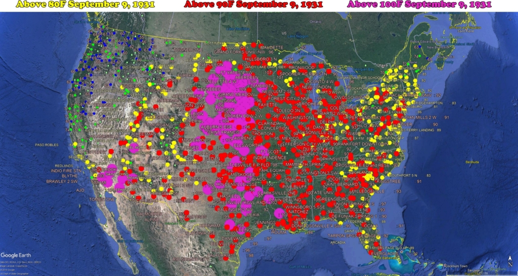
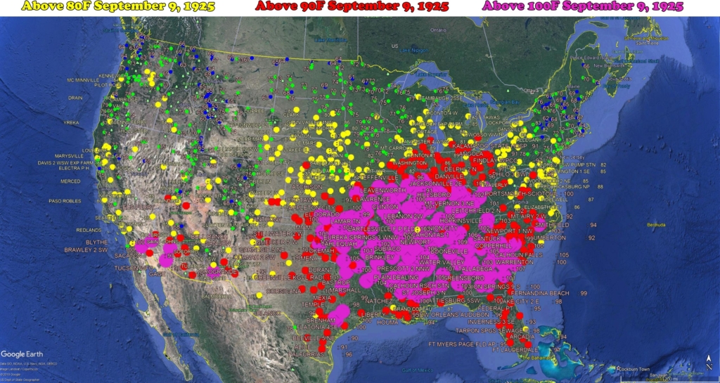
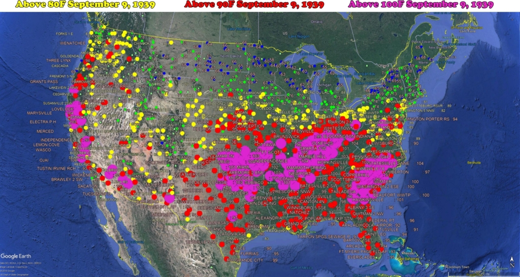
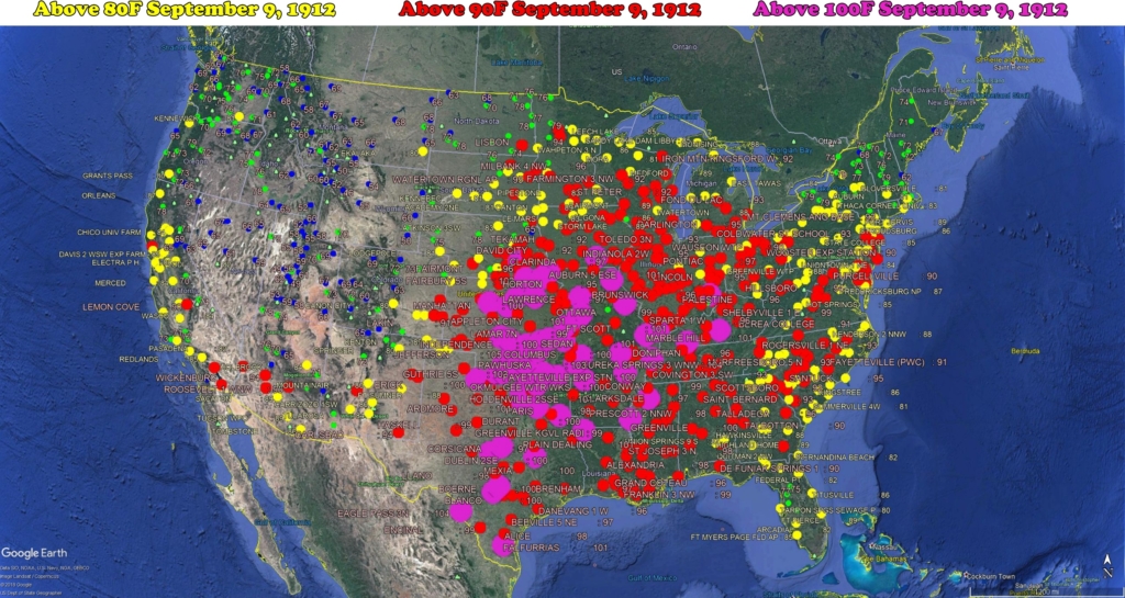
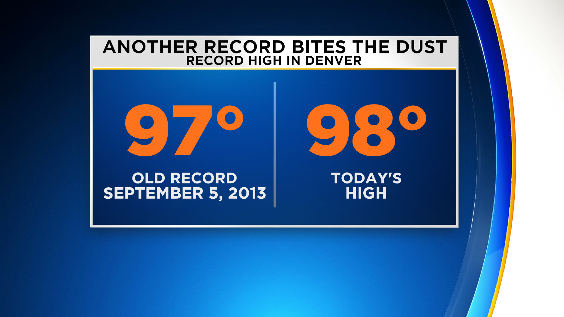
Denver Sets 3rd Heat Record This Month
By Dave AguileraSeptember 5, 2019 at 4:54 pm
Filed Under:Denver News
Denver Sets 3rd Heat Record This Month
DENVER(CBS)- We may be almost a week into September but, summer heat does not want to give up just yet. Denver set another record high on Thursday. The record was 97 degrees set in 2013 and 1899. Denver’s high temp zoomed up to 98 degrees at 2 p.m. on Thursday afternoon.
This continues a hot spell that kicked off the month already with several records. If you remember, (how could you forget), Sunday the 1st had a record high of 98 and Labor Day hit a record of 100!
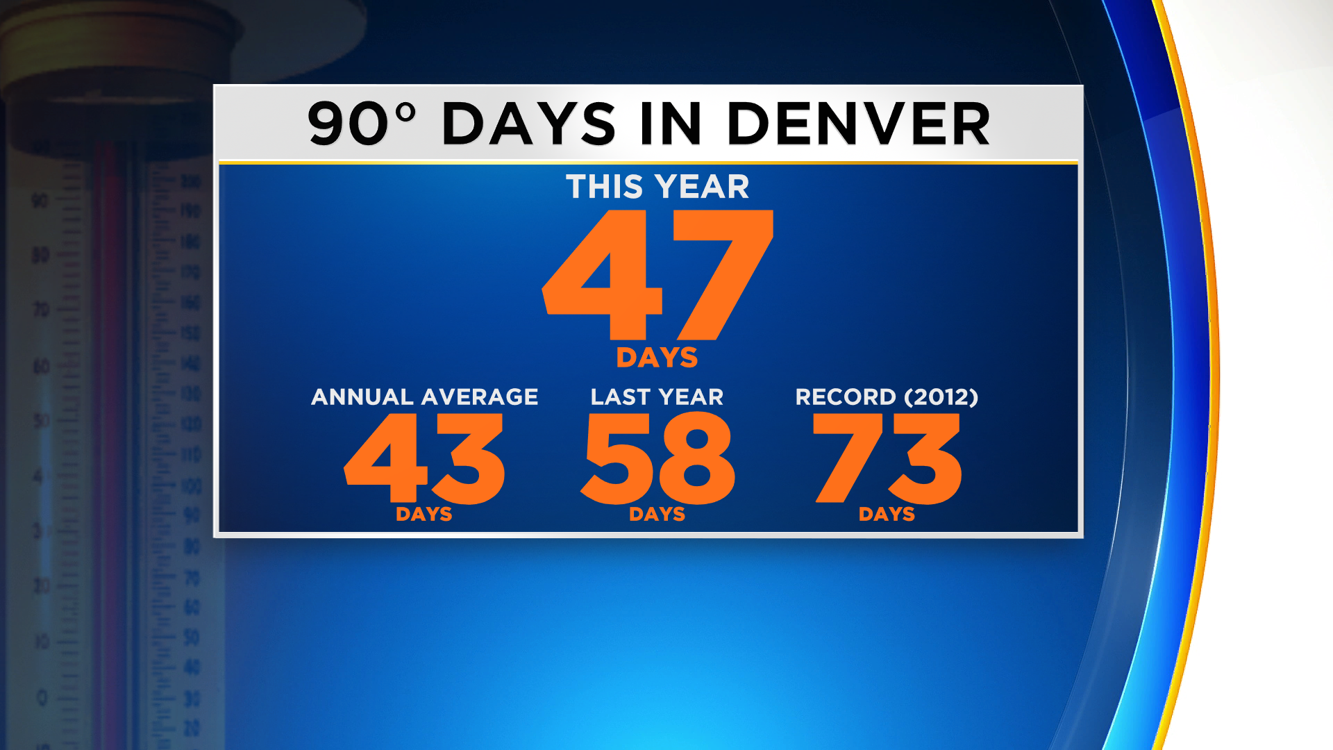
Today’s 98 also adds to the tally of 90-plus degree days for the year. Which now is 47 days. That is 4 days above a normal year.
`
I'm sure Abu Fuk Fuk will be along shortly to post up one warmer area and tell you all that global cold and snow is imaginary...CO2 is in a death struggle with Jack Frost....
Arctic ‘Global Warming’ Mission Scuppered By Mysterious Hard White Substance
Snowing in California
Snowfall in Utah
Snow Blankets Higher Peaks of Utah, Wyoming, Montana and Colorado
A thick layer of snow covered Italy
Winter weather at Rocky Mountain National Park
Early snowfall in Norilsk, Russia Snowfall weeks early
Record cold in Siberia
Coldest September morning EVER for six SA towns
Earliest snow in Sweden in 20 years
CO2 is a having a rough time these days!
‘In for a Roasting’: Australia ‘on brink’ of ‘Apocalyptic’ conditions
Something strange is happening in the air above Antarctica that hasn’t happened since 1992 — and it has dire consequences for Australia.
Jamie Seidel
news.com.au SEPTEMBER 11, 2019
‘In for a roasting’: Australia ‘on brink’ of ‘apocalyptic’ conditions
New footage has emerged from inside the Peregian Beach disaster zone in Queensland, revealing the extent of the crisis.
The Arctic is on fire. Now, Antarctica is suddenly experiencing a heatwave. And that means a looming rainfall apocalypse for Australia.
According to a recent report by senior researchers from the Australian Bureau of Meteorology, we’re in for higher than normal spring temperatures. And less rain.
It’s all because of record warm temperatures in the air swirling above Antarctica.
It’s producing a domino effect.
The stratospheric “polar vortex” has been disrupted. It could even reverse direction.
It’s pushing stormy Southern Ocean wind streams over Tasmania, New Zealand’s South Island and South America’s Patagonia. This is away from its regular route over the Australian mainland.
And that means NSW and southern Queensland — already in parts devastated by bushfires so early in the season — are set to face worsening conditions and an even more catastrophic bushfire season.
SUDDEN STRATOSPHERIC WARMING
“The warming began in the last week of August when temperatures in the stratosphere high above the South Pole began rapidly heating,” the article published in The Conversation reads. Four senior Bureau of Meteorology forecasters compiled it.
“Thanks to improvements in modelling and the Bureau’s new supercomputer, these types of events can be forecast better than ever before.”
It foresees a looming stronger-than-usual melt of sea ice.
It foresees a shift in the typical wind temperatures and patterns coming off the Antarctic continent.
“In the coming weeks the warming is forecast to intensify, and its effects will extend downward to earth’s surface, affecting much of eastern Australia over the coming months,” the forecasters warn.
It is likely to be the most severe Antarctic warming event on record.
The previous highest Antarctic air temperatures were in September 2002. These resulted in Australia’s fourth driest winter on record, with spring-autumn mean-maximum temperatures the highest “by considerable margins”.
This year is shaping up to be worse than 2002. Picture: BOMSource:Supplied
WORLD OF FIRE
This year has been unprecedented in the northern hemisphere. Wildfires have swept through the Arctic, burning large swathes of Canada, Norway, Sweden and Siberian Russia.
These are regions packed full of fuel — from dense forests through to ancient peat bogs.
Usually, it doesn’t burn because it’s frozen or wet.
But year after year of Warming Temperatures have dried out growing patches.
“The north is a big tinderbox, but it’s been limited from burning by the climate,” Merritt Turetsky at the University of Guelph in Canada told New Scientist. “If you remove those climatic constraints, all those fuels are ready to go.”
Fires are raging across NSW and Queensland. Picture: SuppliedSource:News Regional Media
And it’s adding to a warming feedback loop. Fires are killing the vegetation. That exposes the permafrost below to the sun’s heat. And that releases the carbon dioxide and methane within.
Both gases then serve to trap even more heat in the atmosphere, further accelerating the feedback loop.
Antarctica has no such forests. But the extent of its sea ice determines the temperature and course of ocean currents and winds. As the ice retreats, those long-establish flows weaken and shift.
“It is abundantly clear that climate disruption is happening now and everywhere,” UN Secretary-General Antonio Guterres warned earlier this month. “Every week brings us news of more climate-related devastation. And climate impacts are only going to increase in severity and frequency.”
Satellite image released by NASA shows the fires in Brazil. Picture: L. Parmitano/NASA via APSource:AP
POLAR FALLOUT
The Antarctic is the engine room of the southern hemisphere’s climate.
Every winter, westerly winds begin to swirl at speeds of up to 200km/h high above the South Pole.
The mechanics are relatively simple.
It’s cold above the pole, which is experiencing months of darkness. But the Southern Ocean is still being warmed by the sun.
And, as the sun begins its southward march with the onset of spring, the polar vortex is gradually weakened.
“However, in some years this breakdown can happen faster than usual,” the meteorologists write.
In such instances, unusually hot air intrudes over Antarctica — disrupting the temperature mix producing the high-speed westerly winds.
“Very rarely, if the waves are strong enough they can rapidly break down the polar vortex, actually reversing the direction of the winds so they become easterly,” the article continues.
The only time this has been seen to happen was September 2002.
It’s on the brink of happening again.
“Impacts from this stratospheric warming are likely to reach earth’s surface in the next month and possibly extend through to January,” the meteorologists warn.
And that means even less rainfall for much of southern and Central Australia.
With it will come clearer skies and higher temperatures.
“Past stratospheric warming events and associated wind changes have had their strongest effects in NSW and southern Queensland, where springtime temperatures increased, rainfall decreased, and heatwaves and fire risk rose,” they say.
This compounds an already disastrous winter for New South Wales and much of Queensland. There, soil moisture levels actually decreased over what should have been their wet season.
So spring — and summer — will be starting from an already devastatingly dry low.
Have a nice page.
`