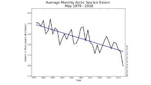
(CNN)The coverage of ice in the Arctic has dwindled to the lowest level ever seen for the month of May, according to the U.S.
National Snow and Ice Data Center.
"During the month, daily sea ice extents tracked about 600,000 square kilometers (232,000 square miles) below any previous year in the 38-year satellite record," according to the center.
For perspective, 232,000 square miles is almost the size of Texas (about 86 percent) and that ice coverage has gone.
This follows a a string of lows from several months of 2016, meaning records were broken for the months of January, February, and April this year.
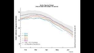
Scientists follow the sea ice cover as one of the key components of monitoring the climate. The Arctic sea ice extent has been a focus area because of its decline and what that tells us about global warming.
Since scientists began using satellite-based data in 1978, the Arctic ice cover has been declining at a rate of about 13 percent per decade,
according to NASA.
Recent data indicate the ice is thinning and the air temperature is rising.
The temperature throughout May across the Arctic Ocean was about two to three degrees Celsius higher than the average seen between 1981 to 2010, according to the National Snow and Ice Data Center's report.