
Billy_Bob
Diamond Member
Billy, you've been predicting this el Nino would fall apart for months now. It has only grown stronger. Where do you get the delusion that you know what the fuck you're talking about? Reality certainly doesn't support it.
Now, for the opinion of the folks who actually know what they're talking about. Emphases mine.
EL NIÑO/SOUTHERN OSCILLATION (ENSO)
DIAGNOSTIC DISCUSSION
issued by
CLIMATE PREDICTION CENTER/NCEP/NWS
and the International Research Institute for Climate and Society
10 September 2015
ENSO Alert System Status: El Niño Advisory
Synopsis: There is an approximately 95% chance that El Niño will continue through Northern Hemisphere winter 2015-16, gradually weakening through spring 2016.
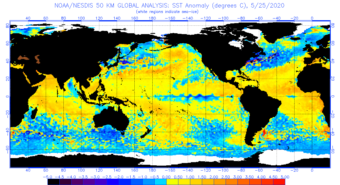
During August, sea surface temperature (SST) anomalies were near or greater than +2.0oC across the eastern half of the tropical Pacific (Fig. 1). SST anomalies increased in the Niño-3.4 and Niño 3-regions, were approximately unchanged in the Niño-4 region, and decreased in the Niño-1+2 region (Fig. 2). Large positive subsurface temperature anomalies persisted in the central and east-central equatorial Pacific during the month (Fig. 3), with the largest departures exceeding 6oC (Fig. 4). The atmosphere remained coupled to the anomalous oceanic warmth, with significant low-level westerly wind anomalies and upper-level easterly wind anomalies persisting from the western to east-central tropical Pacific. Also, the traditional and equatorial Southern Oscillation Index (SOI) were again negative, consistent with enhanced convection over the central and eastern equatorial Pacific and suppressed convection over Indonesia (Fig. 5). Collectively, these atmospheric and oceanic anomalies reflect a strong El Niño.
All models surveyed predict El Niño to continue into the Northern Hemisphere spring 2016, and all multi-model averages predict a peak in late fall/early winter (3-month values of the Niño-3.4 index of +1.5oC or greater; Fig. 6). The forecaster consensus unanimously favors a strong El Niño, with peak 3-month SST departures in the Niño 3.4 region near or exceeding +2.0oC. Overall, there is an approximately 95% chance that El Niño will continue through Northern Hemisphere winter 2015-16, gradually weakening through spring 2016 (click CPC/IRI consensus forecast for the chance of each outcome for each 3-month period).
Across the contiguous United States, temperature and precipitation impacts associated with El Niño are expected to remain minimal during the early Northern Hemisphere fall and increase into the late fall and winter (the 3-month seasonal outlook will be updated on Thursday September 17th). El Niño will likely contribute to a below normal Atlantic hurricane season, and to above-normal hurricane seasons in both the central and eastern Pacific hurricane basins (click Hurricane season outlook for more).
This discussion is a consolidated effort of the National Oceanic and Atmospheric Administration (NOAA), NOAA's National Weather Service, and their funded institutions. Oceanic and atmospheric conditions are updated weekly on the Climate Prediction Center web site (El Niño/La Niña Current Conditions and Expert Discussions). Forecasts are also updated monthly in theForecast Forum of CPC's Climate Diagnostics Bulletin. Additional perspectives and analysis are also available in an ENSO blog. The next ENSO Diagnostics Discussion is scheduled for 8 October 2015. To receive an e-mail notification when the monthly ENSO Diagnostic Discussions are released, please send an e-mail message to: [email protected].
Climate Prediction Center
National Centers for Environmental Prediction
NOAA/National Weather Service
College Park, MD 20740
I'm not sure, Billy Boy, I've ever met someone with such unassailable expertise at making themselves look a fool.
Do you ever look around yourself and verify what these fools tell you or are you simply a left wing fool parrot?


") I never said that it was. haha
I never said that it was. haha