Navigation
Install the app
How to install the app on iOS
Follow along with the video below to see how to install our site as a web app on your home screen.
Note: This feature may not be available in some browsers.
More options
You are using an out of date browser. It may not display this or other websites correctly.
You should upgrade or use an alternative browser.
You should upgrade or use an alternative browser.
Tracking the el nino
- Thread starter ScienceRocks
- Start date
Old Rocks
Diamond Member
http://www.cpc.ncep.noaa.gov/products/analysis_monitoring/lanina/enso_evolution-status-fcsts-web.pdf
The latest weekly SST departures are:
Niño 4 1.1ºC
Niño 3.4 2.4ºC
Niño 3 2.8ºC
Niño 1+2 2.8ºC
2.4. That is a very strong El Nino. And it just keeps hanging on. Oh Billeeeee......................
The latest weekly SST departures are:
Niño 4 1.1ºC
Niño 3.4 2.4ºC
Niño 3 2.8ºC
Niño 1+2 2.8ºC
2.4. That is a very strong El Nino. And it just keeps hanging on. Oh Billeeeee......................
Old Rocks
Diamond Member
And yesterday the temperature hit 87 degrees. In October. In Portland, Oregon. More normal today, 60's and rain. We need a lot more rain.Not a lot in the news about this but the rainstorm that just dumped records amounts on Las Vegas came from the NORTH, not the south as is common.
Billy_Bob
Diamond Member

The mighty Blob is breaking up. It has now split in two and overall temp has dropped -0.75 deg C. The cold waters from the Antarctic have now reached region 4 and the coast of Russia. There are massive ares of deep cooling in the bearing straights and off the coast of Alaska. (Some areas have dropped -3.0 deg C below norm - A 5 deg C swing)
As the cooling now is the dominant theme, the El Nino wont last long. Region one-two is below +1.2 and falling, Region 3-4 is now dropping as the Cooling from region four is taking the same path, with westerlies, as the warm water once did and it is now -2.0
With all the major swings in ocean temps the El Nino will give way to a deep La Nina condition this next year.
With the pause unaffected by the current El Nino even if they get one or two months above average it will be all washed away when the La Nina takes hold and the pause lengthens considerably.
EL NIÑO/SOUTHERN OSCILLATION (ENSO)
DIAGNOSTIC DISCUSSION
issued by
CLIMATE PREDICTION CENTER/NCEP/NWS
and the International Research Institute for Climate and Society
8 October 2015
ENSO Alert System Status: El Niño Advisory
Synopsis: There is an approximately 95% chance that El Niño will continue through Northern Hemisphere winter 2015-16, gradually weakening through spring 2016.
During September, sea surface temperature (SST) anomalies were well above average across the central and eastern Pacific Ocean (Fig. 1). The Niño indices generally increased, although the far western Niño-4 index was nearly unchanged (Fig. 2). Also, relative to last month, the strength of the positive subsurface temperature anomalies decreased slightly in the central and eastern Pacific (Fig. 3), but the largest departures remained above 6oC (Fig. 4). The atmosphere was well coupled with the ocean, with significant low-level westerly wind anomalies and upper-level easterly wind anomalies persisting from the western to the east-central tropical Pacific. Also, the traditional and equatorial Southern Oscillation Index (SOI) values became more negative (stronger), consistent with enhanced convection over the central and eastern equatorial Pacific and suppressed convection over Indonesia (Fig. 5). Collectively, these atmospheric and oceanic anomalies reflect a strong El Niño.
All models surveyed predict El Niño to continue into the Northern Hemisphere spring 2016, and all multi-model averages predict a peak in late fall/early winter (Fig. 6). The forecaster consensus unanimously favors a strong El Niño, with peak 3-month SST departures in the Niño 3.4 region near or exceeding +2.0oC. Overall, there is an approximately 95% chance that El Niño will continue through Northern Hemisphere winter 2015-16, gradually weakening through spring 2016 (click CPC/IRI consensus forecast for the chance of each outcome for each 3-month period).
Across the United States, temperature and precipitation impacts from El Niño are likely to be seen during the upcoming months (the 3-month seasonal outlook will be updated on Thursday October 15th). Outlooks generally favor below-average temperatures and above-median precipitation across the southern tier of the United States, and above-average temperatures and below-median precipitation over the northern tier of the United States.
This discussion is a consolidated effort of the National Oceanic and Atmospheric Administration (NOAA), NOAA's National Weather Service, and their funded institutions. Oceanic and atmospheric conditions are updated weekly on the Climate Prediction Center web site (El Niño/La Niña Current Conditions and Expert Discussions). Forecasts are also updated monthly in theForecast Forum of CPC's Climate Diagnostics Bulletin. Additional perspectives and analysis are also available in an ENSO blog. The next ENSO Diagnostics Discussion is scheduled for 12 November 2015. To receive an e-mail notification when the monthly ENSO Diagnostic Discussions are released, please send an e-mail message to: [email protected].
Climate Prediction Center
National Centers for Environmental Prediction
NOAA/National Weather Service
College Park, MD 20740
***************************************************************************
So, quite obviously, you don't know what the fuck you are talking about.
Old Rocks
Diamond Member
NASA expert: El Niño is 'too big to fail'
LOS ANGELES – Climatologists are predicting that this winter will be unusual across the country because of El Niño that is brewing in the Pacific Ocean.
"There's no longer a possibility that El Niño wimps out at this point. It's too big to fail," Bill Patzert, a climatologist for NASA's Jet Propulsion Laboratory, told the LA Times. "And the winter over North America is definitely not going to be normal."
Scientists say El Niño is getting stronger because of rising sea-level ocean temperatures in the Pacific Ocean and a change of directions of the wind along the equator.
According to LA Times, that means that winter storms that normally drop rain in central America could shift north and move them over California and the southern United States.
Mike Halpert, the deputy director of the Climate Prediction Center, said this El Niño is the second strongest he's seen at this time of the year.
"This could be one of the types of winters like in 1997-98," Halpert said.
Now we know Billy's predictions, let us see how they compare to the scientists. Thus far, it is 100% scientists, 0 % Billy.
Billy_Bob
Diamond Member
Presenting facts rather than opinions is a problem with consensus "science" you rely on MODELS and not empirical evidence.. I post up current empirical evidence and crick posts up broken models..I love it! Every time Billy_Bob puts up one of his ridiculous posts, someone else refutes it with better info.
Keep it up!
The crowd of uninformed morons grows..
Not unexpected however, useful idiot's abound...
Billy_Bob
Diamond Member
So what has happened to their dire predictions of unprecedented warming? It hasn't happened. Why?
What has happened to their dire predictions of heavy wet rain in southern Cali and Arizona? its hasn't happened.. Why?
Most of the mid west and the bread basket of the US is BELOW AVERAGE temperatures.. WHY?
Everything that happened in 1998 has not happened with the current El Nino... WHY?
The models predictions have been so wrong that not one of the consensus scientists can tell us why were not seeing the normal, empirically observed, reaction to an El Nino.. WHY?
Empirical observations leave huge questions about the true nature and strength of our current El Nino. I just have the guts to ask the right questions and say something about it. Funny how the real unaltered data does not conform to the modeled "expectation" or should I say "assumption".
Last edited:
You REPEATEDLY predicted that this el Nino would never take place. It took place. On a WEEKLY basis, you've predicted its imminent demise. It's still going strong and has behaved precisely as the actual experts predicted it would. The only thing this thread has shown is that the real el Nino experts have a pretty good handle on how the things work and that you have ab-so-fucking-lutely NONE.
jc456
Diamond Member
- Dec 18, 2013
- 141,583
- 30,066
- 2,180
besides pretty graphs, where in North America has there been any sign of an El Nino? I've been waiting and to date, nadda here.You REPEATEDLY predicted that this el Nino would never take place. It took place. On a WEEKLY basis, you've predicted its imminent demise. It's still going strong and has behaved precisely as the actual experts predicted it would. The only thing this thread has shown is that the real el Nino experts have a pretty good handle on how the things work and that you have ab-so-fucking-lutely NONE.
Old Rocks
Diamond Member
Then you have been blind. The floods in Texas and the Carolina's are typical of the weather that one expects from an El Nino. The breakup of Atlantic hurricanes is also normal for an El Nino year. And a dryer than normal, in this case, extreme drought for the Pacific Northwest is another expected effect of the El Nino.
You and Billy Bob have to be the dumbest people on this board.
You and Billy Bob have to be the dumbest people on this board.
Old Rocks
Diamond Member
http://www.cpc.ncep.noaa.gov/products/analysis_monitoring/lanina/enso_evolution-status-fcsts-web.pdf
The latest weekly SST departures are:
Niño 4 1.0ºC
Niño 3.4 2.4ºC
Niño 3 2.8ºC
Niño 1+2 2.7ºC
Oh Billeeeeeee............ time to drop the pants again.
The latest weekly SST departures are:
Niño 4 1.0ºC
Niño 3.4 2.4ºC
Niño 3 2.8ºC
Niño 1+2 2.7ºC
Oh Billeeeeeee............ time to drop the pants again.
jc456
Diamond Member
- Dec 18, 2013
- 141,583
- 30,066
- 2,180
oh my gawd, really? LOLOL El Nino didn't have anything to do with either events. hahhahhahahahaahhaahhahahaha, wow dude talk about taking a leap! Why isn't the west coast being affected, isn't that the real prediction, rain relief for California and the northwest. Where is it bubba?Then you have been blind. The floods in Texas and the Carolina's are typical of the weather that one expects from an El Nino. The breakup of Atlantic hurricanes is also normal for an El Nino year. And a dryer than normal, in this case, extreme drought for the Pacific Northwest is another expected effect of the El Nino.
You and Billy Bob have to be the dumbest people on this board.
Old Rocks
Diamond Member
ENSO Temperature & Precipitation Composites
El Niño
Temperature El Niño
Precipitation El Niño
Snow La Niña
Temperature La Niña
Precipitation La Niña
Snow Information on Data, Methods, and Interpretation
3-Month Period
JFM
FMA
MAM
AMJ
MJJ
JJA
JAS
ASO
SON
OND
NDJ
DJF
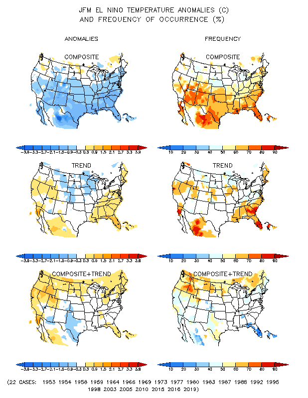
Climate Prediction Center - ENSO Temperature and Precipitation Composites
Oh JCeeee...............
El Niño
Temperature El Niño
Precipitation El Niño
Snow La Niña
Temperature La Niña
Precipitation La Niña
Snow Information on Data, Methods, and Interpretation
3-Month Period
JFM
FMA
MAM
AMJ
MJJ
JJA
JAS
ASO
SON
OND
NDJ
DJF
Climate Prediction Center - ENSO Temperature and Precipitation Composites
Oh JCeeee...............
Old Rocks
Diamond Member
Dumb fuck, as I pointed out, it already has been affected. And the rain may be a bit late, but it will come. Unfortunately, most likely in copious amounts.oh my gawd, really? LOLOL El Nino didn't have anything to do with either events. hahhahhahahahaahhaahhahahaha, wow dude talk about taking a leap! Why isn't the west coast being affected, isn't that the real prediction, rain relief for California and the northwest. Where is it bubba?Then you have been blind. The floods in Texas and the Carolina's are typical of the weather that one expects from an El Nino. The breakup of Atlantic hurricanes is also normal for an El Nino year. And a dryer than normal, in this case, extreme drought for the Pacific Northwest is another expected effect of the El Nino.
You and Billy Bob have to be the dumbest people on this board.
jc456
Diamond Member
- Dec 18, 2013
- 141,583
- 30,066
- 2,180
Sorry, but I just have to laugh at this stuff. You are sacrificing anything to be right? I looked at your link, this year is no where near 1998. NOT NEAR on page 21 of the presentation material. Fact remains nothing has happened in North America to suggest El Nino. your previous bull about Texas and Carolina is hysterical to say the least.http://www.cpc.ncep.noaa.gov/products/analysis_monitoring/lanina/enso_evolution-status-fcsts-web.pdf
The latest weekly SST departures are:
Niño 4 1.0ºC
Niño 3.4 2.4ºC
Niño 3 2.8ºC
Niño 1+2 2.7ºC
Oh Billeeeeeee............ time to drop the pants again.
We'll see bubba who will be right, I have quite a bit of confidence La Nina is here again in NA.
jc456
Diamond Member
- Dec 18, 2013
- 141,583
- 30,066
- 2,180
PREDICTIONS are not FACTs of anything bubba. And again, nothing you pointed out earlier had anything to do with any el nino. nothing and you have no evidence to support it.Dumb fuck, as I pointed out, it already has been affected. And the rain may be a bit late, but it will come. Unfortunately, most likely in copious amounts.oh my gawd, really? LOLOL El Nino didn't have anything to do with either events. hahhahhahahahaahhaahhahahaha, wow dude talk about taking a leap! Why isn't the west coast being affected, isn't that the real prediction, rain relief for California and the northwest. Where is it bubba?Then you have been blind. The floods in Texas and the Carolina's are typical of the weather that one expects from an El Nino. The breakup of Atlantic hurricanes is also normal for an El Nino year. And a dryer than normal, in this case, extreme drought for the Pacific Northwest is another expected effect of the El Nino.
You and Billy Bob have to be the dumbest people on this board.
Old Rocks
Diamond Member
Poor ol' jc, still out of touch reality. Here is a picture of the 1997-1998 El Nino compared to the present El Nino.
Evidence mounts for El Nino that could ease Calif. drought
Evidence mounts for El Nino that could ease Calif. drought
jc456
Diamond Member
- Dec 18, 2013
- 141,583
- 30,066
- 2,180
why don't you address the page I posted off the link you provided? Why is it below 1998?Poor ol' jc, still out of touch reality. Here is a picture of the 1997-1998 El Nino compared to the present El Nino.
Evidence mounts for El Nino that could ease Calif. drought
dude, can you ever post something that doesn't use words like could, would or predict or confidence? How about a factual piece of material that has evidence?
Latest Discussions
- Replies
- 182
- Views
- 2K
- Replies
- 58
- Views
- 654
Forum List
-
-
-
-
-
Political Satire 8870
-
-
-
-
-
-
-
-
-
-
-
-
-
-
-
-
-
-
-
ObamaCare 781
-
-
-
-
-
-
-
-
-
-
-
Member Usernotes 492
-
-
-
-
-
-
-
-
-
-