10,000-year-old Antarctic ice shelf will disappear by 2020

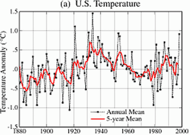
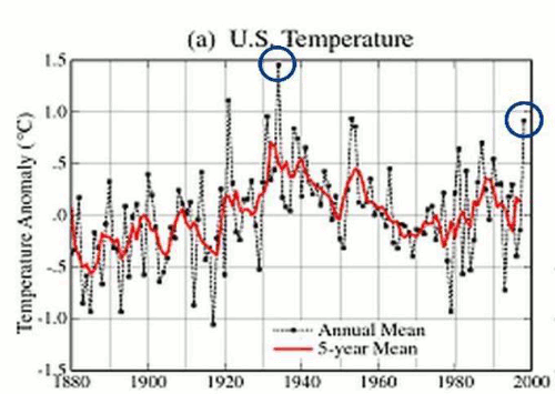
Look, more magic volcano mumbo-jumbo from the jungle savages. The Antarctic volcanoes weren't melting all the ice before, but the scary voodoo magic of the deniers must have brought forth the anger of the volcano gods.

Instead of denier voodoo science, let's try the most recent and accurate data. Cryosat-2, being specifically designed to measure ice, is more accurate than the GRACE satellite's gravity-based measurements.

Increased ice losses from Antarctica detected by CryoSat-2 - McMillan - 2014 - Geophysical Research Letters - Wiley Online Library
---
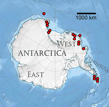
We use 3 years of Cryosat-2 radar altimeter data to develop the first comprehensive assessment of Antarctic ice sheet elevation change. This new data set provides near-continuous (96%) coverage of the entire continent, extending to within 215 km of the South Pole and leading to a fivefold increase in the sampling of coastal regions where the vast majority of all ice losses occur. Between 2010 and 2013, West Antarctica, East Antarctica, and the Antarctic Peninsula changed in mass by −134 ± 27, −3 ± 36, and −23 ± 18 Gt yr−1, respectively.
---

East Antarctica is basically neutral now.

West Antarctica and the peninsula are losing ice big time.
 
Surprise, volcanoes don't do a very good job of melting ice.

Posteruption glacier development within the crater of Mount St. Helens Washington USA

Abstract
The cataclysmic eruption of Mount St. Helens on May 18, 1980, resulted in a large, north-facing amphitheater, with a steep headwall rising 700 m above the crater floor. In this deeply shaded niche a glacier, here named the Amphitheater glacier, has formed. Tongues of ice-containing crevasses extend from the main ice mass around both the east and the west sides of the lava dome that occupies the center of the crater floor. Aerial photographs taken in September 1996 reveal a small glacier in the southwest portion of the amphitheater containing several crevasses and a bergschrund-like feature at its head. The extent of the glacier at this time is probably about 0.1 km2. By September 2001, the debris-laden glacier had grown to about 1 km2 in area, with a maximum thickness of about 200 m, and contained an estimated 120,000,000 m3of ice and rock debris. Approximately one-third of the volume of the glacier is thought to be rock debris derived mainly from rock avalanches from the surrounding amphitheater walls. The newly formed Amphitheater glacier is not only the largest glacier on Mount St. Helens but its aerial extent exceeds that of all other remaining glaciers combined.
 
Well, let us hope that this continues to be the case. However;

Hidden Channels Beneath East Antarctica Could Cause Massive Melt

A glacier the size of California in East Antarctica is in danger of melting away, which could lead to an extreme thaw increases sea levels by about 11.5 feet (3.5 meters) worldwide if the glacier vanishes, a new study finds.

Researchers have found two seafloor channels underneath the floating ice shelf of Totten Glacier in East Antarctica. The channels may let the warmest waters near the glacier to enter beneath the floating ice shelf, causing the rapid thinning of the ice shelf observed to date, the scientists said.

As the ice shelf thins, the point where the glacier starts to float will retreat, raising the sea level, and exposing more ice to the ocean, said the study's lead author, Jamin Greenbaum, a doctoral candidate at the University of Texas at Austin's Institute for Geophysics. [Vanishing Glaciers: See Stunning Images of Earth's Melting Ice]
Floats..............which means the mass is already in the water..............Do me a favor........put water in a large cup add ice and watch it melt.............tell me the effect............

Floating Ice has no significant increase in ocean levels..................The article I cited is a LAND GLACIER.......................

No one denies that areas are melting...................I deny on how much Nature versus man causes...........which to me has not been proven.....................and the AGW folks have lied on data..........and changed their story so many times people don't believe them anymore................

The west lost over 70 Gigatonnes versus gaining 45 gigatonnes............meaning 25 to 30 gigatonnes of ice melted composite in the article cited..............

Which is also why I laughed at the Empire State Building....................
 
Even the article I posted said the volcano doesn't explain all the ice melt..............but whether you like it or not active volcano's still emit HEAT...........and it is a active area............so it is venting some heat............how much ice is melting via it..................would require more research........................and HOW MUCH IS CAUSED by man is still in question................

Early on in this thread another poster talked about how the volcano was a 1000 miles away and didn't impact anything...................quoting a volcano 1000 miles off wasn't exactly the truth now was it......................

As the map I showed showed volcanic activity right in the area in question...................So.........why the deceit..............NO THAT VOLCANO ISN'T THERE.............Yes the Hell they are.........but not that one by name...............They are either there venting or NOT.................by the Research I showed................on a site that agrees with much of the ice data you guys are posting...........

So why the deceit................why did the IPCC get caught purposely manipulating data............even NASA has retracted data that was improperly reported after they got stung on it...............
 
Retreat history of the East Antarctic Ice Sheet since the Last Glacial Maximum

Abstract
The East Antarctic Ice Sheet (EAIS) is the largest continental ice mass on Earth, and documenting its evolution since the Last Glacial Maximum (LGM) is important for understanding its present-day and future behaviour. As part of a community effort, we review geological evidence from East Antarctica that constrains the ice sheet history throughout this period (∼30,000 years ago to present). This includes terrestrial cosmogenic nuclide dates from previously glaciated regions, 14C chronologies from glacial and post-glacial deposits onshore and on the continental shelf, and ice sheet thickness changes inferred from ice cores and continental-scale ice sheet models. We also include new 14C dates from the George V Land – Terre Adélie Coast shelf. We show that the EAIS advanced to the continental shelf margin in some parts of East Antarctica, and that the ice sheet characteristically thickened by 300–400 m near the present-day coastline at these sites. This advance was associated with the formation of low-gradient ice streams that grounded at depths of >1 km below sea level on the inner continental shelf. The Lambert/Amery system thickened by a greater amount (800 m) near its present-day grounding zone, but did not advance beyond the inner continental shelf. At other sites in coastal East Antarctica (e.g. Bunger Hills, Larsemann Hills), very little change in the ice sheet margin occurred at the LGM, perhaps because ice streams accommodated any excess ice build up, leaving adjacent, ice-free areas relatively unaffected. Evidence from nunataks indicates that the amount of ice sheet thickening diminished inland at the LGM, an observation supported by ice cores, which suggest that interior ice sheet domes were ∼100 m lower than present at this time. Ice sheet recession may have started ∼18,000 years ago in the Lambert/Amery glacial system, and by ∼14,000 years ago in Mac.Robertson Land. These early pulses of deglaciation may have been responses to abrupt sea-level rise events such as Meltwater Pulse 1a, destabilising the margins of the ice sheet. It is unlikely, however, that East Antarctica contributed more than ∼1 m of eustatic sea-level equivalent to post-glacial meltwater pulses. The majority of ice sheet recession occurred after Meltwater Pulse 1a, between ∼12,000 and ∼6000 years ago, during a period when the adjacent ocean warmed significantly. Large tracts of East Antarctica remain poorly studied, and further work is required to develop a robust understanding of the LGM ice sheet expansion, and its subsequent contraction. Further work will also allow the contribution of the EAIS to post-glacial sea-level rise, and present-day estimates of glacio-isostatic adjustment to be refined.
 
Meltwater Pulse 1a.........12,000 and 6000 years ago.............

This study shows that most of the ice melted back then................Were there cars, coal burners and etc 6,000 years ago......................

None of this was present then..............yet the ice flows melted at a greater rate back then..............this study done by LIMITED ICE CORE SAMPLES FOR DATING........................

Under this article............they say several times that not enough data has been gathered in the region for a stronger assessment......................

Few data are available from the continental shelf in many regions, including Dronning Maud Land, Enderby Land and much of Wilkes Land (Figs. 1 and 57). The LGM extent of the ice sheet in these areas is largely unconstrained.

In summary, evidence of the LGM extent and thickness of the EAIS remains poorly documented, and is lacking for the majority of the East Antarctic continental margin. Available evidence indicates that the LGM ice sheet was thinner in its centre, and in some areas thickened near the coast, expanding significantly onto the continental shelf.
 
You can't even trust NASA ANYMORE.............

NOAA NASA Dramatically Altered US Temperatures After The Year 2000 Real Science

screenhunter_627-jun-22-21-18.gif


Showed Global cooling until it magically changed after the year 2000

1998changesannotated.gif
 
The fiddling with temperature data is the biggest science scandal ever - Telegraph

Following my last article, Homewood checked a swathe of other South American weather stations around the original three. In each case he found the same suspicious one-way “adjustments”. First these were made by the US government’s Global Historical Climate Network (GHCN). They were then amplified by two of the main official surface records, the Goddard Institute for Space Studies (Giss) and the National Climate Data Center (NCDC), which use the warming trends to estimate temperatures across the vast regions of the Earth where no measurements are taken. Yet these are the very records on which scientists and politicians rely for their belief in “global warming”.

Homewood has now turned his attention to the weather stations across much of the Arctic, between Canada (51 degrees W) and the heart of Siberia (87 degrees E). Again, in nearly every case, the same one-way adjustments have been made, to show warming up to 1 degree C or more higher than was indicated by the data that was actually recorded. This has surprised no one more than Traust Jonsson, who was long in charge of climate research for the Iceland met office (and with whom Homewood has been in touch). Jonsson was amazed to see how the new version completely “disappears” Iceland’s “sea ice years” around 1970, when a period of extreme cooling almost devastated his country’s economy.
 
"Faked data?" It's data produced by your fellow AGE cult members. Are you saying AGW is fake?

I'm saying Spencer fudged it.

And that you attempted to lie to us by pretending it wasn't a Spencer creation.

No one has yet claimed that Spencer didn't accurately report the temperatures predicted by the various global warming computer models. Not a single so-called climate scientists attacked the accuracy of this graph.

Why do you suppose that is?
 
You really are a fucking moron... You mean to tell me that its AGW magic that drives the oceans now?

So you're openly refusing to back up your claim of magical mystery volcanoes?

That's probably for the best.

Poor little libtard... still cant understand simple physics and circulations let alone where the volcanic activity is under Antarctica.

antarctic-volcano-350.gif


That ice melt is above the peninsulas four major volcanic systems.. But lets not let facts get in the way of a good left wit rant.. Showing your stupidity is priceless..

The four on the lower right are in close proximity to the Larsen Ice Sheet.
 
You're article confirms that sea level is rising. Rather, it finds the primary aid to increasing land area on the threatened island is debris from the increased number and intensity of hurricanes.

Well, that's one way to try to make your point.
 
You're article confirms that sea level is rising. Rather, it finds the primary aid to increasing land area on the threatened island is debris from the increased number and intensity of hurricanes.

Well, that's one way to try to make your point.
No shit Sherlock......................I've never denied sea levels rising at all...............as they have been for thousands of years....................In the Atolls I quoted a 4.8 inch increase over 60 years........................

But you miss the point......................over your head...................I said Nature has a way with dealing with Nature....................in this case the Island grew............via coral reefs and debreeee...........yet the skeptics in 2003 were saying the Atolls would be GONE................Mother Jones being one in 2003...................Are they gone...................................

Nope............................

And again................how much is by Man..........and how much is by Nature..............how much of it is NOT MELTING ICE........BUT EXPANDING WATER AT HIGHER TEMPS........................

Let's measure in the coldest time of the year then.............when water temps are cooler..........oops water level dropped..............oops.
 
The four on the lower right are in close proximity to the Larsen Ice Sheet.

And Kilauea is in much closer proximity to Hilo, and Kilauea is very active, yet the vulcanism affects the temperature in Hilo not one bit.

Unless a glacier is literally on top of a volcano, the volcano has zero effect on the glacier.

And you're just really bad at this common sense thing. Hence why you got sucked into the denier cult.
 
If you deniers keep showing that your faith in your magic invisible volcano gods is strong, perhaps they will spare your village.

Or so the theory must go.

Does it bug you deniers that you're the only humans on the planet who believe in your magic invisible volcano gods? Everyone outside of your jungle points out there's no evidence they exist, and that a warmer climate is melting the glaciers.

Iceland. Recently. One of the biggest lava eruptions in recorded history. Right next to a glacier. And the effect on the glacier was ... nada. If the eruption had happened directly under the glacier, it would have been different, but just erupting nearby has no effect. You need a massive eruption directly under a glacier to melt significant ice. And such massive eruptions can't be hidden.
 
Last edited:
If you deniers keep showing that your faith in your magic invisible volcano gods is strong, perhaps they will spare your village.

Or so the theory must go.

Does it bug you deniers that you're the only humans on the planet who believe in your magic invisible volcano gods? Everyone outside of your jungle points out there's no evidence they exist, and that a warmer climate is melting the glaciers.
Scientist pointed out there existence....................and even are reporting possible magma vents under the ice..............

but nah............they are to be dismissed..............cause they fuck up your argument.

:lmao::lmao::lmao:
 
Second Paper Geothermal Heat Melting West Antarctica

More evidence has emerged that geothermal heat and volcanic activity beneath the ice sheet of West Antarctica is contributing to the melting of the Thwaites Glacier, the large, rapidly changing outlet of the West Antarctic Ice Sheet.

A survey of the thickness of the Earth's crust in Antarctica found a particularly thin zone under Marie Byrd Land, where the Thwaites Glacier is located, which is consistent with the presence of a “major volcanic dome”, reports a new paper from a team led by Theresa Damiani, from the US National Geodetic Survey.

This discovery suggests “regionally elevated geothermal heat flux in this sector of the West Antarctic Rift System and consequently the potential for enhanced meltwater production beneath parts of Thwaites Glacier itself”, the researchers report in their paper to be published in the December issue of Earth and Planetary Science Letters, and available online now.

The team used airborne gravimetry – using aircraft-based instruments - combined with satellite data to build a detailed map of the gravitational field over the region.

Their paper, entitled “Variable crustal thickness beneath Thwaites Glacier revealed from airborne gravimetry, possible implications for geothermal heat flux in West Antarctica”, is the second publication this year to report on geothermal activity under the West Antarctic Ice Sheet and follows similar findings in previous research published in June by a team from the Institute for Geophysics at The University of Texas at Austin (UTIG).
 

Forum List

Back
Top