West Coast Mega-Earthquake (8-9+) Predicted THIS WEEK

There would be thousands of places to off load supplies all in and around Puget Sound even after a "mega" quake....

... My little 35 foot Chris Craft is Coast Guard rated to carry up to twenty passengers.

If you can't see how they would be destroyed, you do not grasp the destructive power of the Side effect to such a Hurricane. Tsunami.

A Tsunami in Puget Sound? Not likely.

... Inland the Straight of Juan De Fuca is fairly narrow so a 30 ft tsunami on the coast would only result in 3-4 ft in Puget sound. The only ones that are not constructed on bedrock are in downtown Seattle. They are built on fill material and probably would not survive a 9 earthquake. All the rest are sitting on rock. Like Orcas in the San Juans where I am from all of the Islands coastlines are solid granite ...

One thing ya gotta remember "geologically" speaking is that our coast is a hell of a lot younger than the East Coast. Where they have a lot of sand and dirt under their feet we have for the most part solid rock. Only in certain places like the Denny regrade in downtown Seattle is there enough depth of unstable soil to liquify. Same thing happened in SF. Only the "man made" areas of fill really went nuts during any of their quakes. Much of SF's buildings built up on the hilly areas didn't have much damage at all.

Hi, All!

Huggy, you've made a lot of assumptions here that aren't entirely accurate.

First, earthquakes travel farther through bedrock than through loose soil. The East Coast is actually more bedrock than here -- that's why even small earthquakes travel so far there.

Washington Coast cliffs are not granite: they are sedimentary build-up of former sea bed. That's why you find so many agates and agatized fossils on our beaches: because as the cliffs erode, they drop new agates out of their sedimentary matrix.

With regard to "tsunami" --

The Cascadia Subduction Zone event will cause the ground to rise and fall by about six feet over and over for more than five minutes as the slippage travels along the 600-mile-long fault. This means that in addition to inflow from a tsunami generated at sea, the waters of the Puget Sound itself will splash back and forth, like a gigantic bowl filled with water being vigorously shaken and sloshing from side to side.

It's going to be a pretty rough ride. So, while I hope that the ferry docks will be intact after the event, there is some question whether the ferries themselves will be anywhere to be seen... Or, for that matter, any boat, including your Chris Craft.

However, if you live on the coast and you have food stored up, a well or other source of water that doesn't need an electric pump, basic sanitation, and wood heat, you'll be in pretty good shape... especially if you can hunt, trap, fish, and know how to forage for other traditional native foods. (Stay away from plants with blue or purple flowers, and any bulbs that don't smell like onions. All fuzzy berries are edible. Don't mess with mushrooms unless you already know them really well. If the flowers look at all like tomato flowers, it is not good to eat!)

I found a couple of great videos on YouTube. The first one is called MegaQuake Could Hit North America - BBC (Full Documentary)

[ame=http://www.youtube.com/watch?v=vEgLjgnv_3c]MegaQuake Could Hit North America - BBC (Full Documentary) - YouTube[/ame]

The second video is a 6-minute clip. The first minute of it is a KOMO news story from last Wednesday night, with a geologist discussing the 6.3 quake that day on the Juan de Fuca plate, and saying that "we'll be watching this carefully for the next few months". The rest of the video is the poster's own discussion of what they've seen on USGS over the past few months, and what it might mean. It's a little boring, but I concur what they've seen and the conclusions they've drawn.

[ame=http://www.youtube.com/watch?v=BVu_Sv5MNw8]6.3 Earthquake Hits Off Vancouver Island - November 7th, 2012 - YouTube[/ame]

Thanks to all for your posts on the thread!

-- Paravani

This is an area I am familiar with. Neah Bay, the far North Western corner of WA state.

Note all the friggin granite.
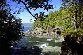
$neah bay.jpg

$neah bay 2.jpg
 
Maybe your neighbors, Nevada, Idaho and Arizona will be the new west coast some day and you won't be nearly as far away. We can only hope.

Quantrill, before you gloat, you may want to research the New Madrid earthquake of 1812.

I found a cool video about it for you, too: The MEGA New Madrid Earthquake is Coming Soon:

Enjoy!

-- Paravani

I don't need to research it Para...my ex-hometown of Paragould, Arkansas is basically in the Mississippi River bottoms of N.E. Arkansas across from the "boothill" of Missouri. It's flat a pancake all over that part of the state...EXCEPT for one ridge of hills (Crowley's Ridge) that runs from the Mississippi river way up in Missouri all the way to Forrest City, AR, about 300 miles to the SW. Formed by the 1811/12 New Madrid Quake. The river actually flowed NORTH during the EQ. I know all about it. But at least we won't fall into the Pacific Ocean.;)

By the way my great, great grandma washed out to sea in the Galveston, TX hurricane of 1900.

moarkeq.jpg
[/URL] [/IMG]

Just recently had an article on the New Madrid fault in Geology, the journal of the Geological Society of America. Seems there is one portion of the fault with a lot of stored energy. No estimate of when that energy might be released.
 
If you can't see how they would be destroyed, you do not grasp the destructive power of the Side effect to such a Hurricane. Tsunami.

A Tsunami in Puget Sound? Not likely. Maybe you don't know the layout around here. The ocean beaches and vicinity could be wiped out by a 30 ft tsunami but frankly the coast population is small. In the winter it is almost non existant. There is also high ground to go to with easy access all along the Washington coast. Inland the Straight of Juan Defuca is fairly narrow so a 30 ft tsunami on the coast would only result in 3-4 ft in Puget sound. Unless it happened at high tide on a full moon we just wouldn't have the flooding like what happened in New Jersy and New York. Even at extreme high tide a tsunami wouldn't do anything to our ferry landings. They are built over 12 feet higher than extreme high tide. The only ones that are not constructed on bedrock are in downtown Seattle. They are built on fill material and probably would not survive a 9 earthquake. All the rest are sitting on rock. Like Orcas in the San Juans where I am from all of the Islands coastlines are solid granite and the homes even near the water are usually up 30 ft from high water already because of the salt water spray from even normal winter storms. My childhood home was 1/4 mile away and about 75 ft high of the water on our beach and we still could still taste salt water in the air during a 60-70 MPH storm.

One thing ya gotta remember "geologically" speaking is that our coast is a hell of a lot younger than the East Coast. Where they have a lot of sand and dirt under their feet we have for the most part solid rock. Only in certain places like the Denny regrade in downtown Seattle is there enough depth of unstable soil to liquify. Same thing happened in SF. Only the "man made" areas of fill really went nuts during any of their quakes. Much of SF's buildings built up on the hilly areas didn't have much damage at all.

The Sound will actually make a Tsunami even worse man. It funnels the Wave causing it to gain power.

That said I am not sure why I even posted on this thread. It's a silly speculative scare piece. Call me when a Mega Quake actually happens.

lol

Well, it is definately a when, not an if. And, no, I won't be calling you. At least, not quite for some time.

As for a scare peice, I wish a lot more people here would realize how serious this event will be. Might be a good idea to have some basic survival supplies put up.

As far as Paravani's predictions go, forecasting quakes is still very much in it's infancy. But we have been having some serious quakes associated with the subduction zone recently. Are they foreshocks? Don't know, could be, might be something else.
 
Hmmm........... No granite there. Basalt, some ocean sediments. The rocks of the Olympic Peninsula were formed at the Juan de Fuca ridge, and thrust up where they are at. All marine basalts, ocean sediment, with some beautiful pillow exposures on the Southeast corner.

Geology of Washington - Olympic Mountains


Basalt is just as igneous as granite. The primary basement rock of the Olympic range is basalt, ergo it is igneous. The valleys are sedementary (tertiary aluvium) just like most of the world, so having your house on that will not be fun as earthquake motion is magnified in aluvium leading to liquifaction and building collapse.

Huggy is correct, after the initial shock and tsunami damage there will still be plenty of places to offload supplies (in point of fact, when it happens, the quake will MAKE new places if only temporary) but quakes that large are truly epic and far beyond the ability of most people to understand.

When it happens, and it will, loss of life will be profound and you had best be prepared to go it alone for up to 6 months because while local supply drops will be fairly easy, getting those supplies to people in the hinterland will be by air only, there will be no road traffic for a long while.
 
Quantrill, before you gloat, you may want to research the New Madrid earthquake of 1812.

I found a cool video about it for you, too: The MEGA New Madrid Earthquake is Coming Soon:

Enjoy!

-- Paravani

I don't need to research it Para...my ex-hometown of Paragould, Arkansas is basically in the Mississippi River bottoms of N.E. Arkansas across from the "boothill" of Missouri. It's flat a pancake all over that part of the state...EXCEPT for one ridge of hills (Crowley's Ridge) that runs from the Mississippi river way up in Missouri all the way to Forrest City, AR, about 300 miles to the SW. Formed by the 1811/12 New Madrid Quake. The river actually flowed NORTH during the EQ. I know all about it. But at least we won't fall into the Pacific Ocean.;)

By the way my great, great grandma washed out to sea in the Galveston, TX hurricane of 1900.

moarkeq.jpg
[/URL] [/IMG]

Just recently had an article on the New Madrid fault in Geology, the journal of the Geological Society of America. Seems there is one portion of the fault with a lot of stored energy. No estimate of when that energy might be released.

Iben Browning, earthquake "expert" and soothsayer deluxe predicted the New Madrid fault would give way in December, 1990. Here is story on Iben's folly. Interesting though.

Iben Browning, New Madrid 1990 incident
 
Does anyone here live on the West Coast? Anyone at all?

-- Paravani

i do, homes. i was sitting on top of the last nisqually quake.

good book you may want to read, i think you can get it on amazon, is cascadia.

let's talk "oceola mudflow" too.

The Super Flood - Page 1 - News - Seattle - Seattle Weekly

so, here i am, sitting on an epicenter in the nisqually and out of H2O and praying for rainier to pop so i can score something to wet my whistle when the nisqually glacier melts and alder dam braks...hmmmm...maybe the UW geologists were behind the new "lets sell the whiskey in the grocery stores" legislation. that will fix us up.

don't freak on me, darlin'. just be ready. man, i hate those things.

:)
 
Quantrill, before you gloat, you may want to research the New Madrid earthquake of 1812.

I found a cool video about it for you, too: The MEGA New Madrid Earthquake is Coming Soon:

Enjoy!

-- Paravani

I don't need to research it Para...
... I know all about it. But at least we won't fall into the Pacific Ocean.;)

Oh, I'm really sorry you missed the video! It isn't ALL about the New Madrid quake -- the last part of it is really choice, and so funny that I've watched it several times.

What you won't hear in the following video is what the Texaco manager said over the phone to the engineer who made a slight miscalculation:

"Ya hear that loud sucking noise, boy? That's the sound of your career."

Here's the video:

[ame=http://www.youtube.com/watch?v=ddlrGkeOzsI]Lake Peigneur sinkhole disaster - YouTube[/ame]

I especially like the part with the 150-foot waterfall. :D

:clap2::clap2::clap2::clap2::clap2::clap2:

-- Paravani
 
Last edited:
Well, it is definitely a when, not an if. ...

As for a scare piece, I wish a lot more people here would realize how serious this event will be. Might be a good idea to have some basic survival supplies put up.

As far as Paravani's predictions go, forecasting quakes is still very much in it's infancy. But we have been having some serious quakes associated with the subduction zone recently. Are they foreshocks? Don't know, could be, might be something else.

As I said, I hope that we have years yet to prepare, as most people are woefully ignorant of the danger and completely unprepared even to the extent of having extra water.

Rocks, I have a video for you. You can skip most of it if you like, but pay special attention to the last ten minutes, starting at about 34:27. They discuss the "Hills Creek Dam" above Eugene, Oregon, and what would happen if an earthquake caused a massive landslide in the dam.

I couldn't actually find a "Hills Creek" dam anywhere around Eugene, but there are two large dams above Eugene that are clearly visible on Google: Lookout Point Dam and Fall Creek Reservoir. (I suspect the History Channel changed the name of Fall Creek Reservoir so as to avoid accusations of libel or other legal issues.)
[ame=http://www.youtube.com/watch?v=hmYABBrIOEg]History Ch Mega Disasters Collection Three 02of10 Dam Breaks XviD AC3 MVGroup org 1 - YouTube[/ame]

These two great dams -- Lookout Point Dam and Fall Creek Reservoir -- are directly east of Eugene, which is in the Willamette River valley. However, as you know, the outlet of the Willamette is much further north, at Portland. On the way there, the Willamette passes through virtually all the major cities in Oregon, including Eugene, Corvallis, Albany, Salem, Wilsonville, Oregon City/West Linn, Lake Oswego, and Milwaukie.

If either or both of the dams east of Eugene break, the water released will scour the Willamette valley. Once the flood reaches Portland, the debris in it will pile up and likely clog the river at its narrowest point, at St John's Bridge. If this happens the water will accumulate behind the bridge, turning downtown Portland and the industrial area into a lake. Even if the river doesn't dam itself at St. John's Bridge, the narrow inlet there will slow the evacuation of water from Portland, causing widespread flooding.

Portland is vulnerable to flooding from other dams upstream besides these two. Closest is the hydroelectric dam at Detroit Lake. Its waters will pass through the town of Jefferson before entering the Willamette at Albany.

There are also the hydroelectric dams at Foster Lake, and upstream from it, the Green Peter Dam. If they are breached, the water will first scour the towns of Sweet Home and Lebanon before continuing on to Jefferson and entering the Willamette at Albany.

Lastly, there are two dams that enter the Willamette south of Eugene, at the town of Cottage Grove: the hydroelectric dams at Dorena Lake and Cottage Grove Lake.

Several of these dams are earthwork construction -- that is, they were made by piling up rocks, gravel, and soil, with minimal use of concrete to bind the layers in place. This type of dam relies almost entirely on gravity for its structural integrity, and it is particularly vulnerable to a breach when the soil is shaken or when the dam is overtopped, as from a wave created by violent seismic motion.

These seven dams I've listed are all very large, creating lakes that were easily found searching Google maps. They are also all less than 150 miles from the Cascadia fault, and will be severely shaken when the event occurs.

If even one of them breaks, virtually every major population center in Oregon will have huge losses of life and property. The entire Willamette valley, with its cities, rich farmland, nurseries, and orchards will be devastated, affecting the nations food supply for years to come.

And Portland itself will face a "reverse tsunami", with huge quantities of debris-laden waters flowing down the Willamette and being slowed by the bottleneck at St. John's Bridge.

So... if you are anywhere near downtown Portland when the quake happens, get out. Go to high ground by the most direct route possible. Walk through broken glass if you must, but get yourself out and up to high ground. You may have as little as 40 minutes before the first water arrives, or as much as four hours if the only dams that break are south of Eugene.

(There really should be tsunami signs in Portland, too, not just on the coast.)

Huggy is correct, after the initial shock and tsunami damage there will still be plenty of places to offload supplies (in point of fact, when it happens, the quake will MAKE new places if only temporary) but quakes that large are truly epic and far beyond the ability of most people to understand.

When it happens, and it will, loss of life will be profound and you had best be prepared to go it alone for up to 6 months because while local supply drops will be fairly easy, getting those supplies to people in the hinterland will be by air only, there will be no road traffic for a long while.

Any evacuation efforts will be severely hampered by the destruction of nearly all our transportation infrastructure. We are a land of rivers and bridges, and all our highways have bridges, overpasses, and underpasses that will fall in a magnitude 8 or 9 quake.

I am hoping that FEMA has already worked out some "what if" scenarios and designated shelter/refugee camp locations throughout the affected area, as victims will not be able to travel far on foot or bicycle.

We have an abundance of fresh water here, but people don't keep their lakes and streams clean in the city, so water filters and water purification tablets will be more useful than just passing out bottles of water. Food, shelter, and heat will be issues, especially in winter. Sanitation will also be a problem, as city water/sewer systems are likely to experience widespread damage.


i was sitting on top of the last nisqually quake.

good book you may want to read, i think you can get it on amazon, is cascadia.

Thanks for the book recommendation. I've read it, and it's very good; but there are a few points the author misses, particularly a more complete discussion of the dam-breach issues I briefly covered above.

so, here i am, sitting on an epicenter in the nisqually and out of H2O and praying for rainier to pop so i can score something to wet my whistle when the nisqually glacier melts and alder dam breaks...hmmmm...maybe the UW geologists were behind the new "lets sell the whiskey in the grocery stores" legislation. that will fix us up.

don't freak on me, darlin'. just be ready. man, i hate those things. :)

Had a cord of wood delivered yesterday, will probably order one more for good measure. That may not be quite enough to see us all the way through the winter, but there's plenty of "uncut" wood hereabouts, and lots of neighbors who will barter with us once they see what we have to offer in trade.

(The woodcutter foolishly said, "I'll take silver and gold," but I bet that he won't once he discovers that he can't eat them!)

-- Paravani
 
Last edited:
I'm not poking fun at your prediction, because something like this could happen at any time, now or in the next thousand years. I was just wondering though, is this suppose to happen around December 21st?

That's actually a very good question. The Aztecs were astronomers who did see some correlation between world events (earthquakes) and the alignment of the moon and stars. They didn't know that some of the "stars" were actually planets that exert gravitational influence on the earth, nor did they realize that the "new" moon and the "full" moon were actually syzygies between the earth, sun, and moon. (A syzygy is when three heavenly bodies line up.)

But in the case of the "12-21-2012 end-of-the-world" scenario, either the Aztecs got it wrong, or whoever was reading their calendar transposed some numbers.

The actual dates of concern are today, 11-14-2012, and 12-12-2012. The reason these two days are significant is that the moon travels in an elliptical path, and these are two of the days when the moon is at its closest perigees for the year -- when it is closest to the earth.

These lunar minimum-perigee dates are occurring at the new moon -- when the moon is in the same direction as the sun.

The earth also travels in an elliptical path around the sun. On the third of January, our planet is at its perihelion -- its closest point to the sun all year. We are already more than one percent closer than our average distance to the sun; and that distance will continue to decrease until January 3rd, when our planet will begin moving away from the sun again.

The reason that minimum perigees, perihelions, new moons, and full moons are important is that gravitational forces increase the closer we are to the sun or the moon; and during the new and full moon, the gravitational pulls of the moon and the sun are combined to act on the earth in a straight line, either together or in exactly opposite directions. That is why the tides are so high in winter at the new moon; because those forces add together.

As stated above, perihelion is always in winter -- on January 3rd.

The lunar minimum perigee doesn't always occur in winter, and it doesn't always coincide with the new moon or the full moon. Unfortunately, when it does coincide, the higher-than-usual gravitational stress can trigger earthquakes.

For example, the last Cascadia Subduction Zone event on January 26th, 1700, occurred just three weeks after perihelion, which closely coincided that year with a full moon that happened at its closest perigee.

Earthquakes trigger earthquakes; so the perihelion/perigee on January 5th in 1700 may have triggered a series of earthquakes like the ones that have been occurring off the coast of Canada, which then triggered the release of the stress on the Cascadia fault.

A similar pattern may be seen in the Subduction Zone event in Kobe, Japan on March 11th of last year. On February 19, the moon's perigee coincided with the day of the full moon -- it was less than a day behind it. Then it swept out to a new moon/apogee... and as it swept back around the earth, moving closer to its closest perigee for the entire year of 2011, the mega-thrust quake occurred. On March 19th, the full moon coincided exactly with the minimum perigee.

Today, November 14th, lunar perigee is only 12 hours behind the new moon. The new moon will be only 357,360 km from the earth; and this time of year, the earth is about 99% of its average distance from the sun.

Next month, on the 12-13th of December, the new moon will again coincide with a minimum perigee of only 357,073 km; and the earth will be only 98.5% of its average distance from the sun.

(Of course, given that "earthquake weather" may lead to earthquakes occurring shortly thereafter rather than on the exact day, the Aztecs may be proven right after all...)


Astronomy source: Yoursky sky chart, and Yoursky Lunar Perigee Calculator found at Fourmilab (Fourmilab is the pet project of John Walker, the millionaire who made his fortune founding Autodesk, the maker of AutoCAD drafting software.)

(To see the sky chart for your location, go to "Set for nearby city" under the "Observing Site" menu, and select your closest major city. The planets and constellations will fill in automatically. Un-check any elements that you don't want to see on the menu and click "update" to remove them.)

Lastly, I want to note here that there have been a couple more quakes on and near the Juan de Fuca plate.

There was a 4.7 "aftershock" to last month's 7.8, but if you zoom in you see that it happened about 75 miles further southeast than the other aftershocks, and it is following along the Cascadia fault. Remember from the film (see "Mega-quake" video in post #33) that Cascadia events begin at one end or the other of the fault; so any large earthquake near either end (like last month's 7.8 off the coast of Canada) can begin the process of triggering an event.

Stock up and stay safe, everybody.

-- Paravani
 
Last edited:
i think congress should pass a law banning any earthquake after august because, when you jump out of bed and run out the door in your shorts, it gets awfully cold up here....
 
Also, when studying the probabilities concerning dam failure, one has to consider that that there are cases where the dam does not fail, yet the result is still catastrophic. The volcanic strata on the north side of Bonneville is on a 2 degree slope to the south. In fact, Cascade Locks is built on debris from a slide that occurred there many years in the past. In a subduction quake, there is a possibility that there would be another great slide. And that the resultant wave would overtop the Bonneville Dam. Even though the dam would most likely remain intact, the resultant wave dowstream in the Columbia would destroy whole communities. My properties would be at risk.
 
I'm not poking fun at your prediction, because something like this could happen at any time, now or in the next thousand years. I was just wondering though, is this suppose to happen around December 21st?

That's actually a very good question. The Aztecs were astronomers who did see some correlation between world events (earthquakes) and the alignment of the moon and stars. They didn't know that some of the "stars" were actually planets that exert gravitational influence on the earth, nor did they realize that the "new" moon and the "full" moon were actually syzygies between the earth, sun, and moon. (A syzygy is when three heavenly bodies line up.)

But in the case of the "12-21-2012 end-of-the-world" scenario, either the Aztecs got it wrong, or whoever was reading their calendar transposed some numbers.

The actual dates of concern are today, 11-14-2012, and 12-12-2012. The reason these two days are significant is that the moon travels in an elliptical path, and these are two of the days when the moon is at its closest perigees for the year -- when it is closest to the earth.

These lunar minimum-perigee dates are occurring at the new moon -- when the moon is in the same direction as the sun.

The earth also travels in an elliptical path around the sun. On the third of January, our planet is at its perihelion -- its closest point to the sun all year. We are already more than one percent closer than our average distance to the sun; and that distance will continue to decrease until January 3rd, when our planet will begin moving away from the sun again.

The reason that minimum perigees, perihelions, new moons, and full moons are important is that gravitational forces increase the closer we are to the sun or the moon; and during the new and full moon, the gravitational pulls of the moon and the sun are combined to act on the earth in a straight line, either together or in exactly opposite directions. That is why the tides are so high in winter at the new moon; because those forces add together.

As stated above, perihelion is always in winter -- on January 3rd.

The lunar minimum perigee doesn't always occur in winter, and it doesn't always coincide with the new moon or the full moon. Unfortunately, when it does coincide, the higher-than-usual gravitational stress can trigger earthquakes.

For example, the last Cascadia Subduction Zone event on January 26th, 1700, occurred just three weeks after perihelion, which closely coincided that year with a full moon that happened at its closest perigee.

Earthquakes trigger earthquakes; so the perihelion/perigee on January 5th in 1700 may have triggered a series of earthquakes like the ones that have been occurring off the coast of Canada, which then triggered the release of the stress on the Cascadia fault.

A similar pattern may be seen in the Subduction Zone event in Kobe, Japan on March 11th of last year. On February 19, the moon's perigee coincided with the day of the full moon -- it was less than a day behind it. Then it swept out to a new moon/apogee... and as it swept back around the earth, moving closer to its closest perigee for the entire year of 2011, the mega-thrust quake occurred. On March 19th, the full moon coincided exactly with the minimum perigee.

Today, November 14th, lunar perigee is only 12 hours behind the new moon. The new moon will be only 357,360 km from the earth; and this time of year, the earth is about 99% of its average distance from the sun.

Next month, on the 12-13th of December, the new moon will again coincide with a minimum perigee of only 357,073 km; and the earth will be only 98.5% of its average distance from the sun.

(Of course, given that "earthquake weather" may lead to earthquakes occurring shortly thereafter rather than on the exact day, the Aztecs may be proven right after all...)


Astronomy source: Yoursky sky chart, and Yoursky Lunar Perigee Calculator found at Fourmilab (Fourmilab is the pet project of John Walker, the millionaire who made his fortune founding Autodesk, the maker of AutoCAD drafting software.)

(To see the sky chart for your location, go to "Set for nearby city" under the "Observing Site" menu, and select your closest major city. The planets and constellations will fill in automatically. Un-check any elements that you don't want to see on the menu and click "update" to remove them.)

Lastly, I want to note here that there have been a couple more quakes on and near the Juan de Fuca plate.

There was a 4.7 "aftershock" to last month's 7.8, but if you zoom in you see that it happened about 75 miles further southeast than the other aftershocks, and it is following along the Cascadia fault. Remember from the film (see "Mega-quake" video in post #33) that Cascadia events begin at one end or the other of the fault; so any large earthquake near either end (like last month's 7.8 off the coast of Canada) can begin the process of triggering an event.

Stock up and stay safe, everybody.

-- Paravani

The Aztecs were astronomers

I don't underget how the Aztecs or contemporary observers of any civilization can call them astronomers without the aid of telescopes.

Isn't this the same group of people that commited human sacrifice when things didn't go their way?

I'm a little more than sceptical of any group that is this enthralled with fantasy land and acts out homicidely on their own citizens or neighbors unlucky enough to get captured when something goes sideways against their belief system.

Just sayin.
 
Last edited:
Plate tectonics and seismology involve so many variables that making predictions is so difficult that proclamations such as this are ridiculous. That's why even the most seasoned seismologists will not link a prediction to a specific time window. Fail thread.
 
We all fail because we are feeding into this, true seismologists would read one line and log off after laughing aloud first.
 
I'm not poking fun at your prediction, because something like this could happen at any time, now or in the next thousand years. I was just wondering though, is this suppose to happen around December 21st?

That's actually a very good question. The Aztecs were astronomers who did see some correlation between world events (earthquakes) and the alignment of the moon and stars. They didn't know that some of the "stars" were actually planets that exert gravitational influence on the earth, nor did they realize that the "new" moon and the "full" moon were actually syzygies between the earth, sun, and moon. (A syzygy is when three heavenly bodies line up.)

But in the case of the "12-21-2012 end-of-the-world" scenario, either the Aztecs got it wrong, or whoever was reading their calendar transposed some numbers.

The actual dates of concern are today, 11-14-2012, and 12-12-2012. The reason these two days are significant is that the moon travels in an elliptical path, and these are two of the days when the moon is at its closest perigees for the year -- when it is closest to the earth.

These lunar minimum-perigee dates are occurring at the new moon -- when the moon is in the same direction as the sun.

The earth also travels in an elliptical path around the sun. On the third of January, our planet is at its perihelion -- its closest point to the sun all year. We are already more than one percent closer than our average distance to the sun; and that distance will continue to decrease until January 3rd, when our planet will begin moving away from the sun again.

The reason that minimum perigees, perihelions, new moons, and full moons are important is that gravitational forces increase the closer we are to the sun or the moon; and during the new and full moon, the gravitational pulls of the moon and the sun are combined to act on the earth in a straight line, either together or in exactly opposite directions. That is why the tides are so high in winter at the new moon; because those forces add together.

As stated above, perihelion is always in winter -- on January 3rd.

The lunar minimum perigee doesn't always occur in winter, and it doesn't always coincide with the new moon or the full moon. Unfortunately, when it does coincide, the higher-than-usual gravitational stress can trigger earthquakes.

For example, the last Cascadia Subduction Zone event on January 26th, 1700, occurred just three weeks after perihelion, which closely coincided that year with a full moon that happened at its closest perigee.

Earthquakes trigger earthquakes; so the perihelion/perigee on January 5th in 1700 may have triggered a series of earthquakes like the ones that have been occurring off the coast of Canada, which then triggered the release of the stress on the Cascadia fault.

A similar pattern may be seen in the Subduction Zone event in Kobe, Japan on March 11th of last year. On February 19, the moon's perigee coincided with the day of the full moon -- it was less than a day behind it. Then it swept out to a new moon/apogee... and as it swept back around the earth, moving closer to its closest perigee for the entire year of 2011, the mega-thrust quake occurred. On March 19th, the full moon coincided exactly with the minimum perigee.

Today, November 14th, lunar perigee is only 12 hours behind the new moon. The new moon will be only 357,360 km from the earth; and this time of year, the earth is about 99% of its average distance from the sun.

Next month, on the 12-13th of December, the new moon will again coincide with a minimum perigee of only 357,073 km; and the earth will be only 98.5% of its average distance from the sun.

(Of course, given that "earthquake weather" may lead to earthquakes occurring shortly thereafter rather than on the exact day, the Aztecs may be proven right after all...)


Astronomy source: Yoursky sky chart, and Yoursky Lunar Perigee Calculator found at Fourmilab (Fourmilab is the pet project of John Walker, the millionaire who made his fortune founding Autodesk, the maker of AutoCAD drafting software.)

(To see the sky chart for your location, go to "Set for nearby city" under the "Observing Site" menu, and select your closest major city. The planets and constellations will fill in automatically. Un-check any elements that you don't want to see on the menu and click "update" to remove them.)

Lastly, I want to note here that there have been a couple more quakes on and near the Juan de Fuca plate.

There was a 4.7 "aftershock" to last month's 7.8, but if you zoom in you see that it happened about 75 miles further southeast than the other aftershocks, and it is following along the Cascadia fault. Remember from the film (see "Mega-quake" video in post #33) that Cascadia events begin at one end or the other of the fault; so any large earthquake near either end (like last month's 7.8 off the coast of Canada) can begin the process of triggering an event.

Stock up and stay safe, everybody.

-- Paravani

Whew (wiping brow). I think after all this, I've got to go to the bathroom and take a perigee
 

Forum List

Back
Top