
How many of you know what goes into making a SLR estimate from altimetry? of the 3mm/yr claimed by climate science, how much is 'adjustments'? I didnt know but I was concerned that SLR doubled at the exact moment that we started to use satellites to calculate it. it seemed like too big of a coincidence to me.
all the following text is from What is happening to sea levels - Global Warming Solved
So, are the satellite estimates reliable? Well, in order to answer that, we have to learn a little bit about how they were actually constructed.
Unfortunately, satellite altimeters don’t actually measure sea levels directly. Instead, they measure the length of time it takes light signals sent from the satellite to bounce back. In general, the longer the signal takes, the further the satellite is from the sea surface. So, in theory, this measurement could be converted into a measure of the sea surface height, i.e., the mean sea level.
However, the conversion is complicated, and a number of other factors need to be estimated and then taken into account. For instance, the distance of the satellite from the Earth’s surface varies slightly as it travels along its orbit, because the gravitational pull of the Earth is not exactly uniform – see the Wikipedia page on “geoid”, and the maps in Figure 19.
So, in order to convert a particular “satellite-sea surface distance” into a sea level measurement, the “satellite-Earth’s surface distance” also needs to be independently measured, e.g., using the DORIS system.
Another complexity is that light takes slightly longer to travel when travelling through water vapour than dry air. So, the water vapour concentrations associated with a given satellite reading also need to be estimated, and accounted for.
As a result, satellite estimates of sea levels involve the use of complex models, approximations, other measurements and calculations. Unfortunately, this means that if there are problems in any of those stages, it could introduce artificial biases into the estimates, possibly making them unreliable… or even worse, wrong.
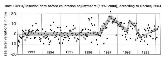
Mörner, 2004 was a controversial paper, and several of the researchers involved with the TOPEX/Poseidon analysis objected to Mörner’s analysis, e.g., Nerem et al., 2007 (Abstract). However, surprisingly, these objections were not over his claim that the raw satellite data showed little trend. They agreed with Mörner that the original satellite data didn’t show much of a sea level rise. Instead, their objection was that he should have used theiradjusted data. They felt the raw data was unreliable, and had developed a series of adjustments which they believed made the trends more realistic.
For example, Keihm et al., 2000 (Abstract; Google Scholar access) had decided that the TOPEX satellite was showing an instrumental negative drift of 1.0-1.5 mm/yr between October 1992 and December 1996. So, they adjusted the data by adding a positive trend of 1.0-1.5 mm/yr to that period. Chambers et al., 2003 (Abstract; Google Scholar access) decided that even more negative biases were introduced when the TOPEX satellite switched to its backup instrument in February 1999. So, they introduced more adjustments. This set of adjustments increased the apparent sea level rise from +1.7 mm/yr to +2.8 mm/yr. Neither set of adjustments affected the period January 1997-January 1999, but as Mörner had noted the raw data already showed significant variability for that period due to the 1997-98 El Niño event. Finally, they believe that an adjustment of +0.3 mm/yr is necessary to account for Peltier’s Glacial Isostatic Adjustments (see Section 4).
It turns out that almost all of the +2.8 mm/yr (or +3.1 mm/yr if Peltier’s post-glacial rebound adjustments are applied) sea level rise in the 1993-present satellite estimates are due to adjustments! The raw data (which no longer seems to be in the public domain) doesn’t show much of a trend, after all.
all the following text is from What is happening to sea levels - Global Warming Solved
So, are the satellite estimates reliable? Well, in order to answer that, we have to learn a little bit about how they were actually constructed.
Unfortunately, satellite altimeters don’t actually measure sea levels directly. Instead, they measure the length of time it takes light signals sent from the satellite to bounce back. In general, the longer the signal takes, the further the satellite is from the sea surface. So, in theory, this measurement could be converted into a measure of the sea surface height, i.e., the mean sea level.
However, the conversion is complicated, and a number of other factors need to be estimated and then taken into account. For instance, the distance of the satellite from the Earth’s surface varies slightly as it travels along its orbit, because the gravitational pull of the Earth is not exactly uniform – see the Wikipedia page on “geoid”, and the maps in Figure 19.
So, in order to convert a particular “satellite-sea surface distance” into a sea level measurement, the “satellite-Earth’s surface distance” also needs to be independently measured, e.g., using the DORIS system.
Another complexity is that light takes slightly longer to travel when travelling through water vapour than dry air. So, the water vapour concentrations associated with a given satellite reading also need to be estimated, and accounted for.
As a result, satellite estimates of sea levels involve the use of complex models, approximations, other measurements and calculations. Unfortunately, this means that if there are problems in any of those stages, it could introduce artificial biases into the estimates, possibly making them unreliable… or even worse, wrong.
Mörner, 2004 was a controversial paper, and several of the researchers involved with the TOPEX/Poseidon analysis objected to Mörner’s analysis, e.g., Nerem et al., 2007 (Abstract). However, surprisingly, these objections were not over his claim that the raw satellite data showed little trend. They agreed with Mörner that the original satellite data didn’t show much of a sea level rise. Instead, their objection was that he should have used theiradjusted data. They felt the raw data was unreliable, and had developed a series of adjustments which they believed made the trends more realistic.
For example, Keihm et al., 2000 (Abstract; Google Scholar access) had decided that the TOPEX satellite was showing an instrumental negative drift of 1.0-1.5 mm/yr between October 1992 and December 1996. So, they adjusted the data by adding a positive trend of 1.0-1.5 mm/yr to that period. Chambers et al., 2003 (Abstract; Google Scholar access) decided that even more negative biases were introduced when the TOPEX satellite switched to its backup instrument in February 1999. So, they introduced more adjustments. This set of adjustments increased the apparent sea level rise from +1.7 mm/yr to +2.8 mm/yr. Neither set of adjustments affected the period January 1997-January 1999, but as Mörner had noted the raw data already showed significant variability for that period due to the 1997-98 El Niño event. Finally, they believe that an adjustment of +0.3 mm/yr is necessary to account for Peltier’s Glacial Isostatic Adjustments (see Section 4).
It turns out that almost all of the +2.8 mm/yr (or +3.1 mm/yr if Peltier’s post-glacial rebound adjustments are applied) sea level rise in the 1993-present satellite estimates are due to adjustments! The raw data (which no longer seems to be in the public domain) doesn’t show much of a trend, after all.
