They are not copies of source documents, as can be seen directly by the copyright (from 2006 actually) which can be seen on the correctly sized version, which conveniently posted in miniature. LOL Don't you think we know your propaganda tricks by now you knucklehead.
How about this one from 1919 then
Or this one from 1923
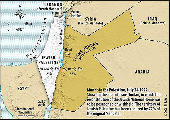
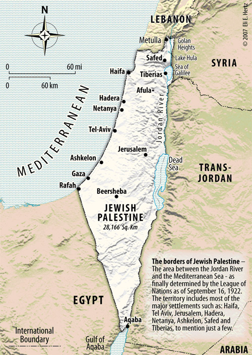
If you knew anything about copyright laws you would know that you put the date you used the image as your copyright date, as it shows you have the original copyright permission to use the image. These are all maps for the LoN to show the extent of the land allocated to the Jews. Unless you want to tell Jordan that it does not exists, along with Iraq, Iran, Syria, Lebanon, Egypt and Saudi. You see they were all granted their lands at the same time
A little older, but no cigar they are both from a book published by Knopf in 1981. As stated on the maps themselves. These are not any way maps "for the LoN" you knucklehead.
http://en.wikipedia.org/wiki/British_Mandate_for_Palestine_(legal_instrument)
Borders[edit]
Map showing boundaries (in red) of the proposed protectorate of Palestine, as suggested by the Zionist representatives at the 1919 Paris Peace Conference, superimposed on modern boundaries.[
citation needed]
Further information:
Borders of Israel and
Borders of Jordan
Northern borders[edit]
The Northern boundary between the British and French mandates was defined in broad terms by the
Franco-British Boundary Agreement of December 1920.
[70] That agreement placed the bulk of the Golan Heights in the French sphere. The treaty also established a joint commission to settle the precise border and mark it on the ground.
[70] The commission submitted its final report on 3 February 1922, and it was approved with some caveats by the British and French governments on 7 March 1923, several months before Britain and France assumed their Mandatory responsibilities on 29 September 1923.
[71][72] Under the treaty, Syrian and Lebanese residents would have the same fishing and navigation rights on
Lake Hula,
Lake Tiberias, and the Jordan River as citizens of the Palestine Mandate, but the government of Palestine would be responsible for policing of the lakes. The Zionist movement pressured the French and British to include as much water sources as possible to
Palestine during the demarcating negotiations. These constant demands influenced the negotiators and finally led to the inclusion of the whole
Sea of Galilee, both sides of the
Jordan river,
Lake Hula, Dan spring, and part of the
Yarmouk. The High Commissioner of Palestine,
Herbert Samuel, had demanded full control of the Sea of Galilee.
[73] The new border followed a 10-meter wide strip along the northeastern shore.
[74]
Following the settlement of the Northern border issue, the British and French governments signed on 2 February 1926 an Agreement of good neighbourly Relations between the mandated territories of Palestine, Syria and Lebanon.
[75]
Southern borders[edit]
The Southern border between Palestine and Egypt was left unchanged from the border established between Egypt and the Ottoman Empire in 1906.
[76]
The Southern border between Transjordan and Arabia was left undefined whilst Abdullah's father remained in power in the
Kingdom of Hejaz. However, following the 1924-25
Saudi conquest of Hejaz, the Hashemite army fled to the northern
Ma'an province of Hejaz, which was then annexed by Transjordan. This was formalised by the
1925 Hadda agreement, with the resulting zig-zag border becoming known as
Winston's Hiccup.
[77]
I think that this source document from September 1922 has the same borders as the map that you can see a copy of. So no propaganda unless you want to destroy the whole of the M.E. and leave it open for land grabs and warfare.