Amazing, we went down 2 miles below sea level to measure the magnetic alignment of the rock 2 miles down....
Yeah, sure...
Rocks on South America are now pointing 90 or so degrees differently than they did 60 million years ago. That is all about the plate spinning as it moves ON A SPHERE NEAR THE POLE...
When do you think South American spun 90 degrees?
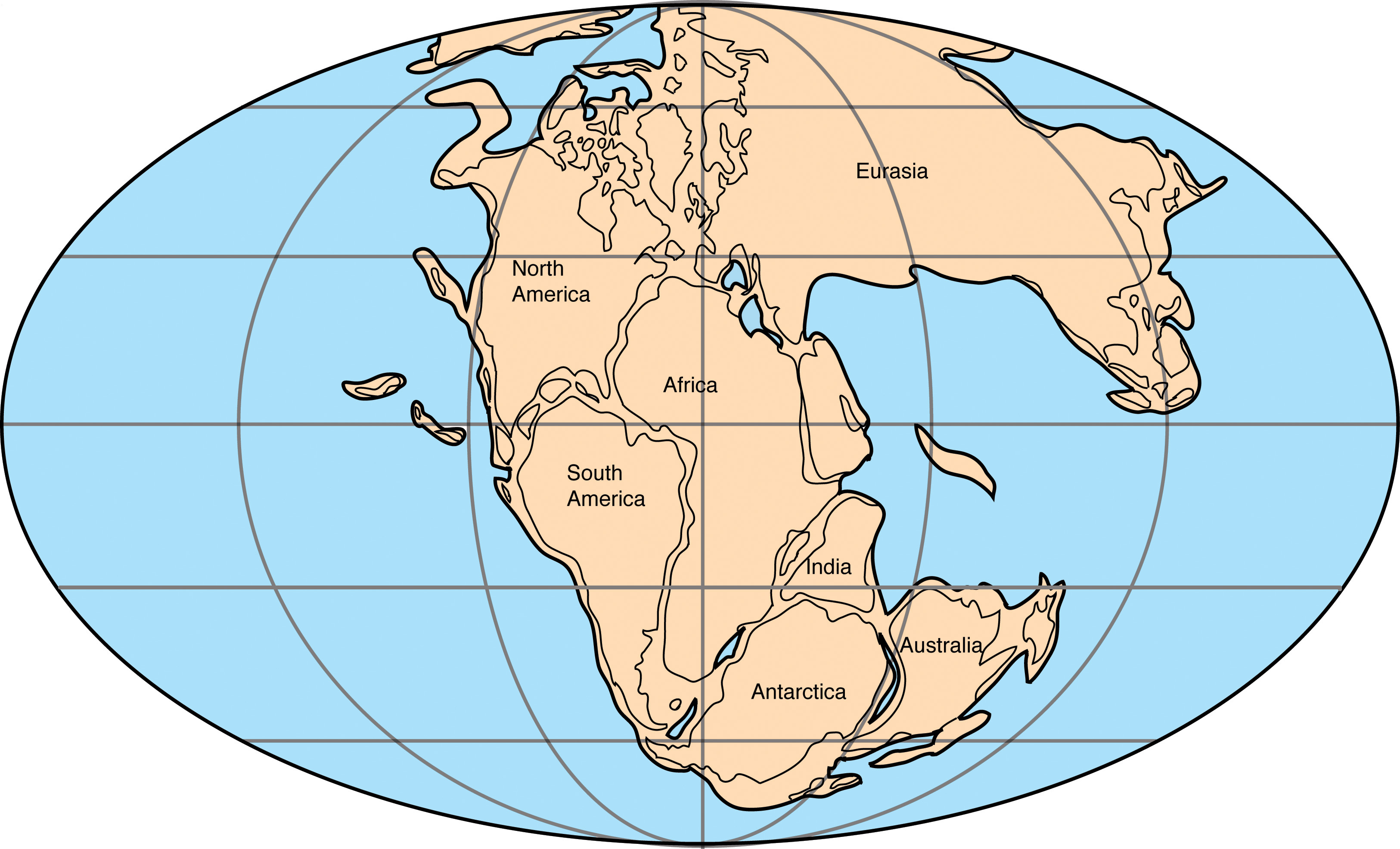
From the Wikipedia article on Pangaea
The forming of supercontinents and their breaking up appears to have been
cyclical through Earth's history. There may have been
many others before Pangaea. The fourth-last supercontinent, called
Columbia or Nuna, appears to have assembled in the period 2.0–1.8
Ga.[15][16] Columbia/Nuna broke up and the next supercontinent,
Rodinia, formed from the
accretion and assembly of its fragments. Rodinia lasted from about 1.1 billion years ago (Ga) until about 750 million years ago, but its exact configuration and geodynamic history are not nearly as well understood as those of the later supercontinents, Pannotia and Pangaea.
When Rodinia broke up, it split into three pieces: the supercontinent of
Proto-Laurasia, the supercontinent of
Proto-Gondwana, and the smaller
Congo craton. Proto-Laurasia and Proto-Gondwana were separated by the
Proto-Tethys Ocean. Next
Proto-Laurasia itself split apart to form the continents of
Laurentia,
Siberia and
Baltica. Baltica moved to the east of Laurentia, and Siberia moved northeast of Laurentia. The splitting also created two new oceans, the
Iapetus Ocean and
Paleoasian Ocean. Most of the above masses coalesced again to form the relatively short-lived supercontinent of
Pannotia. This supercontinent included large amounts of land near the poles and, near the equator, only a relatively small strip connecting the polar masses. Pannotia lasted until 540 Ma, near the beginning of the
Cambrian period and then broke up, giving rise to the continents of
Laurentia,
Baltica, and the southern supercontinent of
Gondwana.
In the
Cambrian period, the continent of
Laurentia, which would later become
North America, sat on the
equator, with three bordering oceans: the
Panthalassic Ocean to the north and west, the
Iapetus Ocean to the south and the
Khanty Ocean to the east. In the Earliest
Ordovician, around 480 Ma, the microcontinent of
Avalonia – a landmass incorporating fragments of what would become eastern
Newfoundland, the southern
British Isles, and parts of
Belgium, northern
France,
Nova Scotia,
New England,
Iberia and northwest Africa – broke free from Gondwana and began its journey to
Laurentia.
[17] Baltica, Laurentia, and Avalonia all came together by the end of the Ordovician to form a minor supercontinent called
Euramerica or Laurussia, closing the Iapetus Ocean. The collision also resulted in the formation of the northern
Appalachians.
Siberia sat near Euramerica, with the
Khanty Ocean between the two continents. While all this was happening, Gondwana drifted slowly towards the South Pole. This was the first step of the formation of Pangaea.
[18]
The second step in the formation of Pangaea was the collision of Gondwana with
Euramerica. By
Silurian time, 440 Ma, Baltica had already collided with Laurentia, forming Euramerica.
Avalonia had not yet collided with
Laurentia, but as Avalonia inched towards Laurentia, the seaway between them, a remnant of the
Iapetus Ocean, was slowly shrinking. Meanwhile,
southern Europe broke off from Gondwana and began to move towards Euramerica across the newly formed
Rheic Ocean. It collided with southern
Baltica in the
Devonian, though this microcontinent was an underwater plate. The Iapetus Ocean's sister ocean, the Khanty Ocean, shrank as an island arc from Siberia collided with eastern Baltica (now part of Euramerica). Behind this
island arc was a new ocean, the
Ural Ocean.
By late Silurian time,
North and
South China split from Gondwana and started to head northward, shrinking the Proto-Tethys Ocean in their path and opening the new
Paleo-Tethys Ocean to their south. In the Devonian Period, Gondwana itself headed towards Euramerica, causing the Rheic Ocean to shrink. In the Early
Carboniferous, northwest
Africa had touched the southeastern coast of
Euramerica, creating the southern portion of the
Appalachian Mountains, the
Meseta Mountains and the
Mauritanide Mountains.
South America moved northward to southern Euramerica, while the eastern portion of Gondwana (
India,
Antarctica and
Australia) headed toward the South Pole from the
equator. North and South China were on independent continents. The
Kazakhstania microcontinent had collided with
Siberia. (Siberia had been a separate continent for millions of years since the deformation of the supercontinent
Pannotia in the Middle Carboniferous.)
Western
Kazakhstania collided with
Baltica in the Late Carboniferous, closing the
Ural Ocean between them and the western Proto-Tethys in them (
Uralian orogeny), causing the formation of not only the
Ural Mountains but also the supercontinent of Laurasia. This was the last step of the formation of Pangaea. Meanwhile, South America had collided with southern
Laurentia, closing the
Rheic Ocean and forming the southernmost part of the
Appalachians and
Ouachita Mountains. By this time, Gondwana was positioned near the South Pole and glaciers were forming in Antarctica, India, Australia, southern Africa and South America. The
North China block collided with
Siberia by Late Carboniferous time, completely closing the Proto-Tethys Ocean.
By Early
Permian time, the
Cimmerian plate split from
Gondwana and headed towards Laurasia, thus closing the
Paleo-Tethys Ocean, but forming a new ocean, the
Tethys Ocean, in its southern end. Most of the landmasses were all in one. By the
Triassic Period, Pangaea rotated a little and the Cimmerian plate was still travelling across the shrinking Paleo-Tethys, until the
Middle Jurassic time. The Paleo-Tethys had closed from west to east, creating the
Cimmerian Orogeny. Pangaea, which looked like a
C, with the new Tethys Ocean inside the
C, had rifted by the Middle Jurassic, and its deformation is explained below.