Navigation
Install the app
How to install the app on iOS
Follow along with the video below to see how to install our site as a web app on your home screen.
Note: This feature may not be available in some browsers.
More options
Style variation
You are using an out of date browser. It may not display this or other websites correctly.
You should upgrade or use an alternative browser.
You should upgrade or use an alternative browser.
A discussion on the stability of the West Antarctic Ice Sheet (WAIS) and its consequences
- Thread starter Crick
- Start date
- Thread starter
- #22
Try Evidence of an active volcanic heat source beneath the Pine Island Glacier for a very good article on this specific topic.
...
"...to date there is no direct evidence of melt by present day volcanism beneath the WAIS."
...
"However, the locations and extent of volcanic activity along the WARS are debated, because many of these 138 known volcano-like features are buried beneath several kilometers of ice, and some evidence suggests that much of the interior subglacial WARS is dormant."
....
"Despite the accumulation of evidence, definitive proof of contemporary subglacial volcanism in West Antarctica is still missing."
.....
"Presently, the greatest contributor to ice shelf instability around Antarctica appears to be an increase in ocean heat supply to the cavities of Antarctic ice shelves19. Circumpolar Deep Water (CDW) is the primary heat source for melting glacial ice and its increased presence on the Amundsen Sea continental shelf has been implicated in the rapid melting and grounding line retreat observed beneath the Pine Island Glacier19,20,21 and in the atmospheric warming along the western Antarctic Peninsula22. The ocean–atmosphere mechanisms that draw more CDW onto Antarctic continental shelves are challenging to characterize and remain poorly understood23, although the concentration and distribution of CDW and its year-to-year variations have revealed connections to climatic changes in the regional winds."
...
"...to date there is no direct evidence of melt by present day volcanism beneath the WAIS."
...
"However, the locations and extent of volcanic activity along the WARS are debated, because many of these 138 known volcano-like features are buried beneath several kilometers of ice, and some evidence suggests that much of the interior subglacial WARS is dormant."
....
"Despite the accumulation of evidence, definitive proof of contemporary subglacial volcanism in West Antarctica is still missing."
.....
"Presently, the greatest contributor to ice shelf instability around Antarctica appears to be an increase in ocean heat supply to the cavities of Antarctic ice shelves19. Circumpolar Deep Water (CDW) is the primary heat source for melting glacial ice and its increased presence on the Amundsen Sea continental shelf has been implicated in the rapid melting and grounding line retreat observed beneath the Pine Island Glacier19,20,21 and in the atmospheric warming along the western Antarctic Peninsula22. The ocean–atmosphere mechanisms that draw more CDW onto Antarctic continental shelves are challenging to characterize and remain poorly understood23, although the concentration and distribution of CDW and its year-to-year variations have revealed connections to climatic changes in the regional winds."
Last edited:
CrusaderFrank
Diamond Member
- May 20, 2009
- 160,856
- 87,299
- 2,645
Did you miss all the work from 2016 on about mapping out ACTIVE VOLCANIC RIFTS, er, caused by atmospheric CO2 which also tilted Earth's orbitThe grounding line of the WAIS has been retreating for several years now. The bedrock on which the sheet rests is itself, below sea level due to the weight of the ice resting on it for many millennia, though the top of the sheet is many hundreds of feet above sea level. This article explains the mechanics of the glacier and the floating ice sheet and how and why the grounding line is retreating. A complete collapse of the sheet - the retreat of the grounding line to the geographical limits of the sheet - will raise global sea level by 3.3 meters (about eleven feet). Many scientists believe the collapse of the sheet is an irreversible process and the only question is time: how long it will take to happen. It could take a century. It could happen in less than a single year. A ten foot rise in global sea level over the course of one year would be a massively catastrophic event reminiscent of the flooding of the Black Sea through the Bosporus Straits, save on a much larger scale with millions more humans affected.
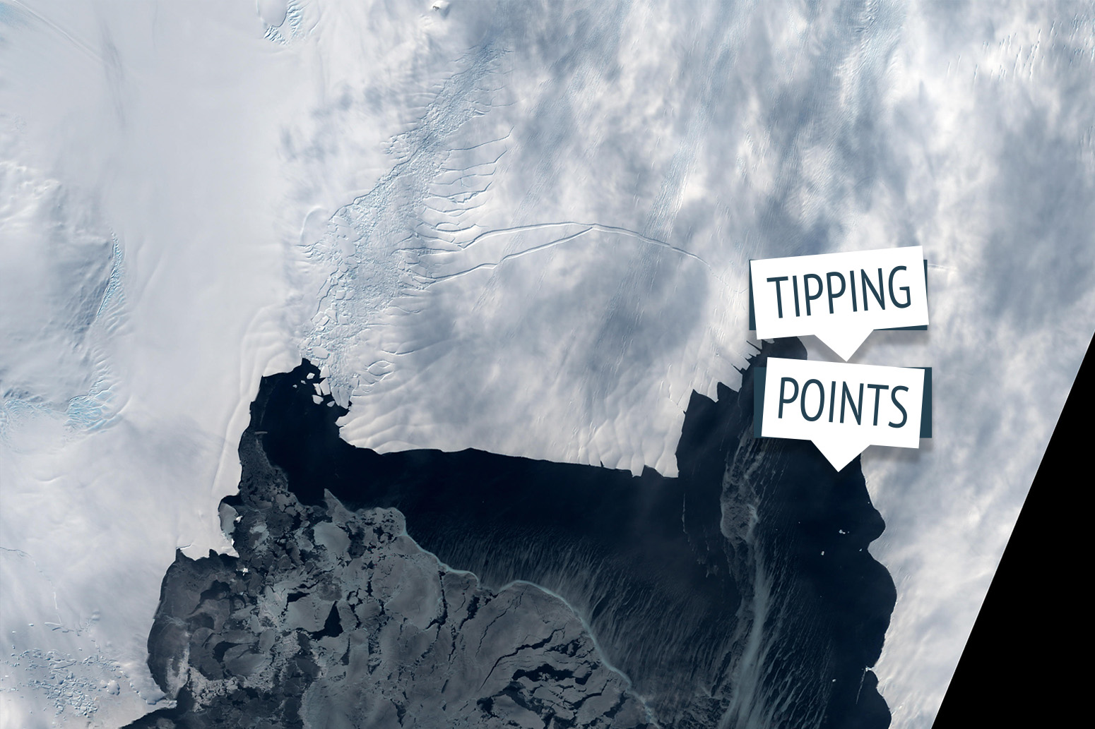
Guest post: How close is the West Antarctic ice sheet to a ‘tipping point’?
Between its east and west ice sheets and its peninsula, Antarctica holds enough ice to raise global sea levels by around 60m. The West Antarctic ice sheet (WAIS) is a relatively small part, containing an amount of ice equivalent to 3.3m of sea level rise. Yet, most of it sits in a precarious...www.carbonbrief.org
Did you miss all the work from 2016 on about mapping out ACTIVE VOLCANIC RIFTS under those glaciers footings? You must have.. Aint gonna be your guide or sherpa.. There's threads in this forum -- maybe 6 or 8 of them on this,.
Would be a ******* shame if we spent $31Trill "decarbonizing" the atmosphere and THEN discovered the MORE RATIONAL reason for those WAIS glaciers losing their shoreline footings..
Wouldn't it???
CrusaderFrank
Diamond Member
- May 20, 2009
- 160,856
- 87,299
- 2,645
Try Evidence of an active volcanic heat source beneath the Pine Island Glacier for a very good article on this specific topic.
...
to date there is no direct evidence of melt by present day volcanism beneath the WAIS.
...
However, the locations and extent of volcanic activity along the WARS are debated, because many of these 138 known volcano-like features are buried beneath several kilometers of ice, and some evidence suggests that much of the interior subglacial WARS is dormant
....
Despite the accumulation of evidence, definitive proof of contemporary subglacial volcanism in West Antarctica is still missing.
.....
Presently, the greatest contributor to ice shelf instability around Antarctica appears to be an increase in ocean heat supply to the cavities of Antarctic ice shelves19. Circumpolar Deep Water (CDW) is the primary heat source for melting glacial ice and its increased presence on the Amundsen Sea continental shelf has been implicated in the rapid melting and grounding line retreat observed beneath the Pine Island Glacier19,20,21 and in the atmospheric warming along the western Antarctic Peninsula22. The ocean–atmosphere mechanisms that draw more CDW onto Antarctic continental shelves are challenging to characterize and remain poorly understood23, although the concentration and distribution of CDW and its year-to-year variations have revealed connections to climatic changes in the regional winds21,24.
Is a cold volcano like cold fusion?
flacaltenn
Diamond Member
That is NOT what the people investigating this very issue say. And you'll have to pardon me if I take their word over yours.
Who's INVESTIGATING here? Your carbonnidgets link is not.. They are regurgitating OLD SCIENCE. With some STOLEN "new graphics"..
Don't listen to me.. Because you're using the WRONG SOURCES and you LOVE to be clueless.. So dont even TRY to educate yourself as to all the NEW WORK and theories about "Antarctica melting"..
Go find a 2018 or forward SCIENTIFIC study about the WAIS melting if you dont want to look like a cultist denier..
Likkmee
Gold Member
PANIX ! Gentleman start all your engines !Is it time to panic?
flacaltenn
Diamond Member
Seriously man... This science aint too hard. Go type what I told you to type into Bing and educate yourself before you become another JonesTown victim..
Here... I'll start ya out.. Took 22 seconds...
Here... I'll start ya out.. Took 22 seconds...
- The West Antarctic Ice Sheet (WAIS) flows through the volcanically active West Antarctic Rift System (WARS). The aeromagnetic method has been the most useful geophysical tool for identification of subglacial volcanic rocks, since 1959–64 surveys, particularly combined with 1978 radar ice-sounding.
Author: John C. Behrendt, John C. Behrendt
Cited by: 15
Publish Year: 2013
The aeromagnetic method as a tool to identify Cenozoic ...
www.sciencedirect.com/science/article/pii/S0040195112003605
Was this helpful?
https://www.usmessageboard.com/javascript:void(0)
https://www.usmessageboard.com/javascript:void(0) - PEOPLE ALSO ASK
Is the West Antarctic ice sheet losing mass?
What is the volume of the Antarctic ice sheet?
How is Antarctic ice sheet contributing to sea level rise?
How many volcanoes are in Antarctica?
Feedback 

New volcanoes identified under the West Antarctic Ice SheetA team from the School of Geosciences, University of Edinburgh, has identified 138 volcanoes, 91 of which were newly identified, under the West Antarctic Ice Sheet (WAIS). Improving our understanding of subglacial volcanic activity across the province is important both for helping to constrain how volcanism and rifting may have influenced ice-sheet growth and decay over previous glacial cycles, and in light of …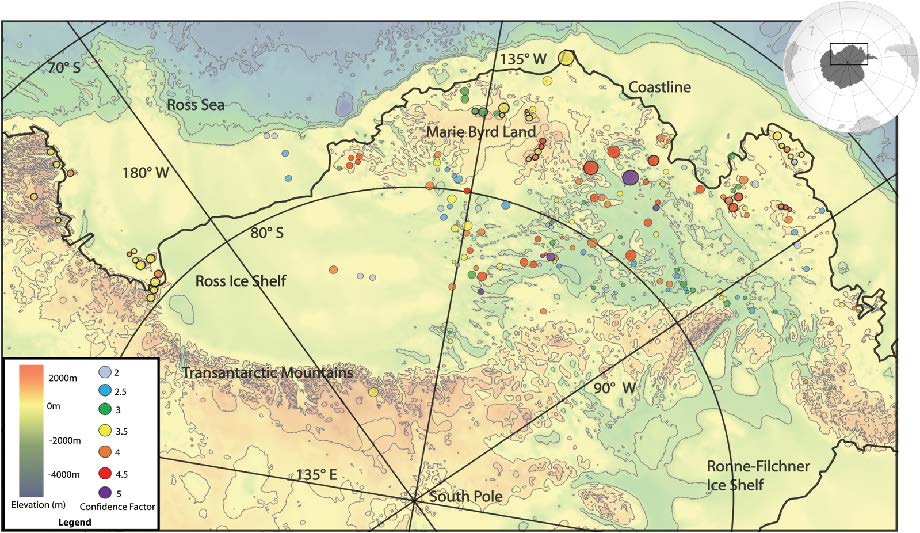
New volcanoes identified under the West Antarctic Ice Sheet | SCAR
A team from the School of Geosciences, University of Edinburgh, has identified 138 volcanoes, 91 of which were newly identified, under the West Antarctic Ice Sheet (WAIS). Improving our understanding of subglacial volcanic activity across the province is important both for helping to constrain... www.scar.org
- [PDF]
of rifts beneath the WAIS has been termed the West Antarctic Rift System (WARS), and is bounded by the Transantarctic Mountains to the south (Fig. 1). In other major rift systems of the world, rift interiors with thin, stretched crust are associated with considerable volcanism (e.g. Siebert & Simkin 2002). However, in West Antarctica, only a few
A new volcanic province: an inventory of subglacial ...
Scientists found 91 volcanoes under Antarctica. Here’s ...Aug 25, 2017 · Aug 25, 2017 · The volcanoes are located in the West Antarctic Rift System, a 2,200-mile valley created by separating tectonic plates. The discovery brings the total number of volcanoes in the area to 138. The ...
Scientists Again Raise Government Estimate of Oil Leak Rate
Updated 7:47pm ET Details are still emerging about the scope of the new oil flow estimate, and it is not yet completely clear whether that estimate apples only to the flow rate after the riser was cut on June 3, or whether it applies to the flow rate before June 3 as well. We are continuing to... www.pbs.org
Evidence of an active volcanic heat source beneath the ...Jun 22, 2018 · Determining the distribution of geothermal heat flow to the WAIS is complicated by the presence of an extensional volcanic rift system that stretches …
Evidence of an active volcanic heat source beneath the Pine Island Glacier - Nature Communications
The West Antarctic Ice Sheet sits atop an extensional rift system with volcano-like features, yet we do not know if any of these volcanoes are active, because identifying subglacial volcanism remains a challenge. Here, the authors find evidence in helium isotopes that a large volcanic heat... www.nature.com
- Cited by: 10
- Publish Year: 2018
- Author: Brice Loose, Alberto C. Naveira Garabato, Peter Schlosser, Peter Schlosser, William J. Jenkins, Davi...
West Antarctic Rift System - WikipediaThe West Antarctic Rift System is a series of rift valleys between East and West Antarctica. It encompasses the Ross Embayment, the Ross Sea, the area under the Ross Ice Shelf and a part of Marie Byrd Land in West Antarctica, reaching to the base of the Antarctic Peninsula. It has an estimated length of 3,000 km and a width of approximately 700 km. Its evolution is due to lithospheric thinning of an …
West Antarctic Rift System - Wikipedia
en.wikipedia.org
Volcanic rocks and subglacial volcanism beneath the West ...Dec 01, 2012 · Radar ice sounding and aeromagnetic surveys reported over the West Antarctic Ice Sheet (WAIS) have been interpreted as evidence of subglacial volcanic eruptions over a very extensive area (>500,000 km2 ) of the volcanically active West Antarctic rift system interpreted as caused by subglacial volcanic …
Volcanic rocks and subglacial volcanism beneath the West Antarctic Ice Sheet in the West Antarctic Rift System, (WAIS) from aeromagnetic and radar ice sounding - Thiel Subglacial Volcano as possible source of the ash layer in the WAISCORE
Radar ice sounding and aeromagnetic surveys reported over the West Antarctic Ice Sheet (WAIS) have been interpreted as evidence of subglacial volcanic eruptions over a very extensive area (>500,000 km2 ) of the volcanically active West Antarctic rift system interpreted as caused by subglacial... ui.adsabs.harvard.edu
- Author: J. C. Behrendt
- Publish Year: 2012
Antarctica 3 – The Volcanoes of Marie Byrd LandOct 04, 2017 · Oct 04, 2017 · Mt. Murphy is one of the most eroded volcanoes in the region. The WAIS tends to protect the bases of volcanoes inland. It is too thin next to the coast to do the same. Murphy dates to 8 Ma. Mount Andrus is the youngest of a triple grouping of volcanoes in the Ames Range of Marie Byrd Land.
- [PDF]
There are ~100 short-wavelength, steep-gradient, negative magnetic anomalies observed over the West Antarctic Ice Sheet (WAIS), or about 10% of the approximately 1000 short-wavelength, shallow-source, high-amplitude (50->1000 nT) "volcanic" magnetic anomalies in the CWA survey. These negative anomalies also indicate volcanic activity during a period of magnetic reversal >780 Ka.
One hundred negative magnetic anomalies over the West ...
West Antarctic Ice Sheet - WikipediaSep 15, 2004 · The West Antarctic ice sheet (WAIS) has warmed by more than 0.1 °C (0.18 °F)/decade in the last fifty years, and the warming is the strongest in winter and spring. Although this is partly offset by fall cooling in East Antarctica, this effect was restricted to the 1980s and 1990s.
West Antarctic Ice Sheet - Wikipedia
Volcano discovered under fastest-melting Antarctic glacier ...Jul 19, 2018 · The West Antarctic Ice Sheet (WAIS), which includes the PIG, sits on top of the West Antarctic Rift System that includes 138 known volcanoes. …
| EarthSky
Antarctica’s Pine Island Glacier is melting, thanks to warming waters from below. What’s more, a recent study has discovered a volcano beneath the glacier. earthsky.org
Images of Volcanic Rifts Antarctica Wais
bing.com/images

See all
See all images
- https://www.usmessageboard.com/javascript:void(0);

- Thread starter
- #28
The article I linked is from the June 2018 Nature. I have not seen whatever it is you're talking about. I know there has been very recent work, conducted late last year and early this year that shows warmer than expected water sweeping under the WAIS from the deep water current. I think this issue will turn out to be analogous to those who wanted to argue that volcanoes must be the source of all the extra CO2 in the atmosphere until actually checking the numbers it was found that human emissions made the volcanic contribution absolutely trivial. I suspect the amount of heat coming in from the ocean vastly overwhelms an geothermal heating present.Did you miss all the work from 2016 on about mapping out ACTIVE VOLCANIC RIFTS, er, caused by atmospheric CO2 which also tilted Earth's orbitThe grounding line of the WAIS has been retreating for several years now. The bedrock on which the sheet rests is itself, below sea level due to the weight of the ice resting on it for many millennia, though the top of the sheet is many hundreds of feet above sea level. This article explains the mechanics of the glacier and the floating ice sheet and how and why the grounding line is retreating. A complete collapse of the sheet - the retreat of the grounding line to the geographical limits of the sheet - will raise global sea level by 3.3 meters (about eleven feet). Many scientists believe the collapse of the sheet is an irreversible process and the only question is time: how long it will take to happen. It could take a century. It could happen in less than a single year. A ten foot rise in global sea level over the course of one year would be a massively catastrophic event reminiscent of the flooding of the Black Sea through the Bosporus Straits, save on a much larger scale with millions more humans affected.
Guest post: How close is the West Antarctic ice sheet to a ‘tipping point’?
Between its east and west ice sheets and its peninsula, Antarctica holds enough ice to raise global sea levels by around 60m. The West Antarctic ice sheet (WAIS) is a relatively small part, containing an amount of ice equivalent to 3.3m of sea level rise. Yet, most of it sits in a precarious...
Did you miss all the work from 2016 on about mapping out ACTIVE VOLCANIC RIFTS under those glaciers footings? You must have.. Aint gonna be your guide or sherpa.. There's threads in this forum -- maybe 6 or 8 of them on this,.
Would be a ******* shame if we spent $31Trill "decarbonizing" the atmosphere and THEN discovered the MORE RATIONAL reason for those WAIS glaciers losing their shoreline footings..
Wouldn't it???
The nature article does make a few points in your favor: that you can have substantial geothermal heating without active vulcanism and that even a small amount of melt can have a large effect on glacial speed and mass loss. I am not going to say that the volcanoes of Antarctica aren't melting some ice, but I will not agree that they are the one and only cause of Antarctic mass loss and/or that global warming is not the primary driver.
PS, nice collection. You posted while I was writing this. I note that you linked to the same article I did; the one from which I drew those quotes. Can I assume you agree with those findings? Let me also point out that finding volcanic material (with magnetometers) is NOT the same thing as finding active vulcanism.
flacaltenn
Diamond Member
Try Evidence of an active volcanic heat source beneath the Pine Island Glacier for a very good article on this specific topic.
...
"...to date there is no direct evidence of melt by present day volcanism beneath the WAIS."
...
"However, the locations and extent of volcanic activity along the WARS are debated, because many of these 138 known volcano-like features are buried beneath several kilometers of ice, and some evidence suggests that much of the interior subglacial WARS is dormant."
....
"Despite the accumulation of evidence, definitive proof of contemporary subglacial volcanism in West Antarctica is still missing."
.....
"Presently, the greatest contributor to ice shelf instability around Antarctica appears to be an increase in ocean heat supply to the cavities of Antarctic ice shelves19. Circumpolar Deep Water (CDW) is the primary heat source for melting glacial ice and its increased presence on the Amundsen Sea continental shelf has been implicated in the rapid melting and grounding line retreat observed beneath the Pine Island Glacier19,20,21 and in the atmospheric warming along the western Antarctic Peninsula22. The ocean–atmosphere mechanisms that draw more CDW onto Antarctic continental shelves are challenging to characterize and remain poorly understood23, although the concentration and distribution of CDW and its year-to-year variations have revealed connections to climatic changes in the regional winds."
Your lying about the link,.. Just picking out what sounds right to you.. They GIVE DIRECT EVIDENCE in the first 2 paragraphs.. But since their funding was through grants on GW research, they have to please the sponsors...
FROM THE TOP OF YOUR LINK...
Evidence of an active volcanic heat source beneath the Pine Island Glacier
Download PDF
- Article
- Open Access
- Published: 22 June 2018
Evidence of an active volcanic heat source beneath the Pine Island Glacier
- Brice Loose,
- Alberto C. Naveira Garabato,
- Peter Schlosser,
- William J. Jenkins,
- David Vaughan &
- Karen J. Heywood
- 8849 Accesses
- 10 Citations
- 557 Altmetric
- Metricsdetails
Abstract
Tectonic landforms reveal that the West Antarctic Ice Sheet (WAIS) lies atop a major volcanic rift system. However, identifying subglacial volcanism is challenging. Here we show geochemical evidence of a volcanic heat source upstream of the fast-melting Pine Island Ice Shelf, documented by seawater helium isotope ratios at the front of the Ice Shelf cavity. The localization of mantle helium to glacial meltwater reveals that volcanic heat induces melt beneath the grounded glacier and feeds the subglacial hydrological network crossing the grounding line. The observed transport of mantle helium out of the Ice Shelf cavity indicates that volcanic heat is supplied to the grounded glacier at a rate of ~ 2500 ± 1700 MW, which is ca. half as large as the active Grimsvötn volcano on Iceland. Our finding of a substantial volcanic heat source beneath a major WAIS glacier highlights the need to understand subglacial volcanism, its hydrologic interaction with the marine margins, and its potential role in the future stability of the WAIS.*********************************************
Now what part of the EVIDENCE WE present -- DID YOU NOT UNDERSTAND?'
Maybe I was wrong.. Maybe YOU CANT read the original scientific sourcing... Go fetch some of the links in the unedited Bing search I gave you before...
flacaltenn
Diamond Member
Our finding of a substantial volcanic heat source beneath a major WAIS glacier highlights the need to understand subglacial volcanism, its hydrologic interaction with the marine margins, and its potential role in the future stability of the WAIS.]
How'd you miss that in the first paragraph and then LIE about what the paper was about??
- Thread starter
- #31
I saw that text. I also saw the text I quoted from the very same article. Grimsvotn was used as a comparison, I believe, because it is completely subglacial. It is not particularly large, so being half its size does not make this Pine Island volcano a significant player. The reason for the article is because this is apparently the first clear evidence found of active volcanism under the ice. The authors did NOT conclude that it was the cause of the retreat of the WAIS grounding line or any other dynamic currently ascribed to global warming.
flacaltenn
Diamond Member
Crick Seriously man -- I beg you.. When a source like carbonbriefs lies and misleads you so BADLY while IGNORING recent scientific findings -- FIRE THEM.. NEVER use them again. Protect yourself by doing some basic "primary source" investigations...
There's a REASON we're not seeing the daily/weekly scare headlines on Global Warming like we did when we wrestled on this 10 years ago... Simply BECAUSE -- GW has BECOME "less scary".. And there's now a whole industry that will mislead and LIE to keep it more scary than it needs to be.
You and I go back a ways on this.. I'm really just trying to help.. Not ripping you, just ultra frustrated with folks who DUMPED the science along the way and are shamans and voodoo artists now..
TroglocratsRdumb
Diamond Member
- Aug 11, 2017
- 46,039
- 68,225
- 3,615
We are entering a new ice age.
We should be building coal powered electric plants.
 earth-chronicles.com
We should be building coal powered electric plants.
British astrophysicists: “We are currently entering a deep mini – ice age” | Earth Chronicles News
"We are currently plunging into a deep mini - ice age," says British astrophysicist Pierce Corbin, "and there is no way out." It's going to get colder and colder on average over the next 20 years, says Corbin, who has a Bachelor of Science degree. in physics and a master of science in...
earth-chronicles.com
flacaltenn
Diamond Member
I saw that text. I also saw the text I quoted from the very same article. Grimsvotn was used as a comparison, I believe, because it is completely subglacial. It is not particularly large, so being half its size does not make this Pine Island volcano a significant player. The reason for the article is because this is apparently the first clear evidence found of active volcanism under the ice. The authors did NOT conclude that it was the cause of the retreat of the WAIS grounding line or any other dynamic currently ascribed to global warming.
They just stated those Megawatts of heat WERE a source of melting AT THE FOOTER...
Glacier is NOT melting from atmospheric heating.. Southern ocean surface waters have the LOWEST GW anomaly of all the oceans.. So look up OCCAM'S razor and study the ALTERNATIVE postulations before you INSIST we're all gonna drown from CO2 Atmos warming at the South Pole..
We MAY DROWN.. But NOW since about 2013, it appears it could be sudden and COUPLED to a new volcanic period at the South pole..
- Thread starter
- #36
Bullshit. NOTHING you have posted here gives that conclusion. Here are several contemporary studies (and an article) finding water warmer than expected responsible for the grounding line retreat under Thwaites.
 advances.sciencemag.org
 www.nature.com

 www.sciencedirect.com

 www.pnas.org
Science | AAAS
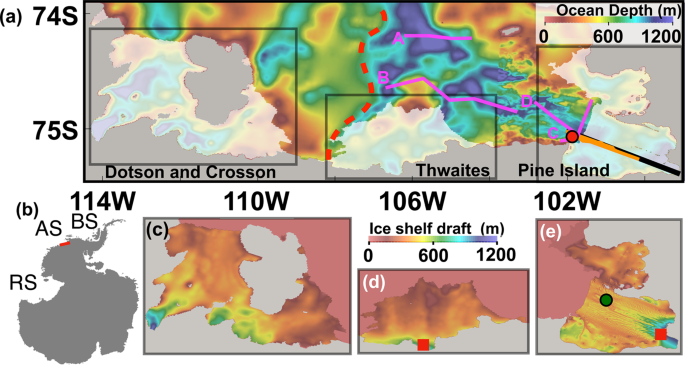
Pathways of ocean heat towards Pine Island and Thwaites grounding lines - Scientific Reports
In the Amundsen Sea, modified Circumpolar Deep Water (mCDW) intrudes into ice shelf cavities, causing high ice shelf melting near the ice sheet grounding lines, accelerating ice flow, and controlling the pace of future Antarctic contributions to global sea level. The pathways of mCDW towards...
www.nature.com
How much, how fast?: A science review and outlook for research on the instability of Antarctica's Thwaites Glacier in the 21st century
Constraining how much and how fast the West Antarctic Ice Sheet (WAIS) will change in the coming decades has recently been identified as the highest p…
www.sciencedirect.com
Damage accelerates ice shelf instability and mass loss in Amundsen Sea Embayment
Pine Island Glacier and Thwaites Glacier in the Amundsen Sea Embayment are among the fastest changing outlet glaciers in Antarctica. Yet, projecting the future of these glaciers remains a major uncertainty for sea level rise. Here we use satellite imagery to show the development of damage areas...
www.pnas.org
Thwaites and Pine Island Glaciers Rapid Melting Could Cause Four Foot Global Sea Level Rise | Climate and Global Change Center | University of Pittsburgh
Thwaites and Pine Island Glaciers Rapid Melting Could Cause Four Foot Global Sea Level Rise Caroline Weiss
www.climatecenter.pitt.edu
flacaltenn
Diamond Member
Bullshit. NOTHING you have posted here gives that conclusion. Here are several contemporary studies (and an article) finding water warmer than expected responsible for the grounding line retreat under Thwaites.
Science | AAAS
Pathways of ocean heat towards Pine Island and Thwaites grounding lines - Scientific Reports
In the Amundsen Sea, modified Circumpolar Deep Water (mCDW) intrudes into ice shelf cavities, causing high ice shelf melting near the ice sheet grounding lines, accelerating ice flow, and controlling the pace of future Antarctic contributions to global sea level. The pathways of mCDW towards...
How much, how fast?: A science review and outlook for research on the instability of Antarctica's Thwaites Glacier in the 21st century
Constraining how much and how fast the West Antarctic Ice Sheet (WAIS) will change in the coming decades has recently been identified as the highest p…
Damage accelerates ice shelf instability and mass loss in Amundsen Sea Embayment
Pine Island Glacier and Thwaites Glacier in the Amundsen Sea Embayment are among the fastest changing outlet glaciers in Antarctica. Yet, projecting the future of these glaciers remains a major uncertainty for sea level rise. Here we use satellite imagery to show the development of damage areas...
Thwaites and Pine Island Glaciers Rapid Melting Could Cause Four Foot Global Sea Level Rise | Climate and Global Change Center | University of Pittsburgh
Thwaites and Pine Island Glaciers Rapid Melting Could Cause Four Foot Global Sea Level Rise Caroline Weisswww.climatecenter.pitt.edu
All you're doing is tossing up with personal contextual understanding. Most of those papers are simply mapping and modeling the fractures at the seaside edges of those glaciers WITHOUT a lot of discussion as to fundamental MECHANISMS causing the damage.
CONTEXT is KEY here.. You have magnetometry studies showing ACTIVE VOLCANIC FISSURES all thru that area. With several papers MEASURING the power output potential of the heating and SHOWING the certainty that it melting the ENTIRE footing at the bedrock.. You poo-poo'd 1000MWatss of power estimated. That's enough to continually power ONE MILLION HOMES!
And the other context you're missing is that that power is present under IMMENSE PRESSURE -- causing TEMPERATURES TO SOAR from being under the weight of a several hundred meters of ice. So even small power forcings have enhanced heating and damage potential..
Your 1st link is the only detailed description of "warm water channels" that flow AROUND the footing of those glaciers. At about 1DegC -- these are not EVEN warm water. But they could contribute to etching out channels in the footing at DEPTHS of over 100 meters.
Now realize that those "warm currents" have been a PERMANENT FEATURE of this planet since the first Ice Age. So they are NOT NEW, not KNOWN to be warming from global warming and certainly have had 10s of 1000s of years to DO their damage. These are part of the north-south ocean thermodynamics that take heat from the tropics and remove cooler ocean waters and send them back north..
Best part of the links I reviewed was the PNAS paper about the "Damage Assessment".. In that paper there's a video showing a progression of the GROWTH of the "ice tongue" at the Pig Island Glacier. (the PIG) Video uses the available satellite record since 1973 to show the LOSS of the ice at the seaward edge of the PIG. NOTE: that in that video -- most of the impressive calving and retreat ONLY OCCURS IN THE PAST FIVE years of so of that 40 year time period !!!!! Seemingly NOT RELATED to a ocean current theory about a mechanism that's BEEN THERE for 300,000 years at least..
Watch the video --
Last edited:
flacaltenn
Diamond Member
The much more LIKELY "melting" force is the discovery of over 100 VERIFIED magnetic anomalies caused by past volcanic activity. Which now are suspect to finding CHEMICAL verification of ACTIVE VOLCANISM.. Here's a pic of the "lava cones" found directly UNDER the WAIS..

- Thread starter
- #39
Bullshit. NOTHING you have posted here gives that conclusion. Here are several contemporary studies (and an article) finding water warmer than expected responsible for the grounding line retreat under Thwaites.
Science | AAAS
Pathways of ocean heat towards Pine Island and Thwaites grounding lines - Scientific Reports
In the Amundsen Sea, modified Circumpolar Deep Water (mCDW) intrudes into ice shelf cavities, causing high ice shelf melting near the ice sheet grounding lines, accelerating ice flow, and controlling the pace of future Antarctic contributions to global sea level. The pathways of mCDW towards...
How much, how fast?: A science review and outlook for research on the instability of Antarctica's Thwaites Glacier in the 21st century
Constraining how much and how fast the West Antarctic Ice Sheet (WAIS) will change in the coming decades has recently been identified as the highest p…
Damage accelerates ice shelf instability and mass loss in Amundsen Sea Embayment
Pine Island Glacier and Thwaites Glacier in the Amundsen Sea Embayment are among the fastest changing outlet glaciers in Antarctica. Yet, projecting the future of these glaciers remains a major uncertainty for sea level rise. Here we use satellite imagery to show the development of damage areas...
Thwaites and Pine Island Glaciers Rapid Melting Could Cause Four Foot Global Sea Level Rise | Climate and Global Change Center | University of Pittsburgh
Thwaites and Pine Island Glaciers Rapid Melting Could Cause Four Foot Global Sea Level Rise Caroline Weisswww.climatecenter.pitt.edu
All you're doing is tossing up with personal contextual understanding. Most of those papers are simply mapping and modeling the fractures at the seaside edges of those glaciers WITHOUT a lot of discussion as to fundamental MECHANISMS causing the damage.
CONTEXT is KEY here.. You have magnetometry studies showing ACTIVE VOLCANIC FISSURES all thru that area. With several papers MEASURING the power output potential of the heating and SHOWING the certainty that it melting the ENTIRE footing at the bedrock.. You poo-poo'd 1000MWatss of power estimated. That's enough to continually power ONE MILLION HOMES!
And the other context you're missing is that that power is present under IMMENSE PRESSURE -- causing TEMPERATURES TO SOAR from being under the weight of a several hundred meters of ice. So even small power forcings have enhanced heating and damage potential..
Your 1st link is the only detailed description of "warm water channels" that flow AROUND the footing of those glaciers. At about 1DegC -- these are not EVEN warm water. But they could contribute to etching out channels in the footing at DEPTHS of over 100 meters.
Now realize that those "warm currents" have been a PERMANENT FEATURE of this planet since the first Ice Age. So they are NOT NEW, not KNOWN to be warming from global warming and certainly have had 10s of 1000s of years to DO their damage. These are part of the north-south ocean thermodynamics that take heat from the tropics and remove cooler ocean waters and send them back north..
Best part of the links I reviewed was the PNAS paper about the "Damage Assessment".. In that paper there's a video showing a progression of the GROWTH of the "ice tongue" at the Pig Island Glacier. (the PIG) Video uses the available satellite record since 1973 to show the LOSS of the ice at the seaward edge of the PIG. NOTE: that in that video -- most of the impressive calving and retreat ONLY OCCURS IN THE PAST FIVE years of so of that 40 year time period !!!!! Seemingly NOT RELATED to a ocean current theory about a mechanism that's BEEN THERE for 300,000 years at least..
Watch the video --
Show us the specific text in your sources that claim that their magnetometer data indicate those volcanoes are CURENTLY active. What I see and copied up here are statements indicating that the anomalies detected ARE ANOMALIES because their polarity is different than the current magnetic field orientation and thus they were laid down PRIOR to the last pole reversal, 780,000 years ago. If not, why the **** would anyone be using a magnetometer to find them?!?!?
flacaltenn
Diamond Member
Bullshit. NOTHING you have posted here gives that conclusion. Here are several contemporary studies (and an article) finding water warmer than expected responsible for the grounding line retreat under Thwaites.
Science | AAAS
Pathways of ocean heat towards Pine Island and Thwaites grounding lines - Scientific Reports
In the Amundsen Sea, modified Circumpolar Deep Water (mCDW) intrudes into ice shelf cavities, causing high ice shelf melting near the ice sheet grounding lines, accelerating ice flow, and controlling the pace of future Antarctic contributions to global sea level. The pathways of mCDW towards...
How much, how fast?: A science review and outlook for research on the instability of Antarctica's Thwaites Glacier in the 21st century
Constraining how much and how fast the West Antarctic Ice Sheet (WAIS) will change in the coming decades has recently been identified as the highest p…
Damage accelerates ice shelf instability and mass loss in Amundsen Sea Embayment
Pine Island Glacier and Thwaites Glacier in the Amundsen Sea Embayment are among the fastest changing outlet glaciers in Antarctica. Yet, projecting the future of these glaciers remains a major uncertainty for sea level rise. Here we use satellite imagery to show the development of damage areas...
Thwaites and Pine Island Glaciers Rapid Melting Could Cause Four Foot Global Sea Level Rise | Climate and Global Change Center | University of Pittsburgh
Thwaites and Pine Island Glaciers Rapid Melting Could Cause Four Foot Global Sea Level Rise Caroline Weisswww.climatecenter.pitt.edu
All you're doing is tossing up with personal contextual understanding. Most of those papers are simply mapping and modeling the fractures at the seaside edges of those glaciers WITHOUT a lot of discussion as to fundamental MECHANISMS causing the damage.
CONTEXT is KEY here.. You have magnetometry studies showing ACTIVE VOLCANIC FISSURES all thru that area. With several papers MEASURING the power output potential of the heating and SHOWING the certainty that it melting the ENTIRE footing at the bedrock.. You poo-poo'd 1000MWatss of power estimated. That's enough to continually power ONE MILLION HOMES!
And the other context you're missing is that that power is present under IMMENSE PRESSURE -- causing TEMPERATURES TO SOAR from being under the weight of a several hundred meters of ice. So even small power forcings have enhanced heating and damage potential..
Your 1st link is the only detailed description of "warm water channels" that flow AROUND the footing of those glaciers. At about 1DegC -- these are not EVEN warm water. But they could contribute to etching out channels in the footing at DEPTHS of over 100 meters.
Now realize that those "warm currents" have been a PERMANENT FEATURE of this planet since the first Ice Age. So they are NOT NEW, not KNOWN to be warming from global warming and certainly have had 10s of 1000s of years to DO their damage. These are part of the north-south ocean thermodynamics that take heat from the tropics and remove cooler ocean waters and send them back north..
Best part of the links I reviewed was the PNAS paper about the "Damage Assessment".. In that paper there's a video showing a progression of the GROWTH of the "ice tongue" at the Pig Island Glacier. (the PIG) Video uses the available satellite record since 1973 to show the LOSS of the ice at the seaward edge of the PIG. NOTE: that in that video -- most of the impressive calving and retreat ONLY OCCURS IN THE PAST FIVE years of so of that 40 year time period !!!!! Seemingly NOT RELATED to a ocean current theory about a mechanism that's BEEN THERE for 300,000 years at least..
Watch the video --
Show us the specific text in your sources that claim that their magnetometer data indicate those volcanoes are CURENTLY active. What I see and copied up here are statements indicating that the anomalies detected ARE ANOMALIES because their polarity is different than the current magnetic field orientation and thus they were laid down PRIOR to the last pole reversal, 780,000 years ago. If not, why the **** would anyone be using a magnetometer to find them?!?!?
You dont know how to read science literature. One group finds the fissures. Another maps chemical evidence of activity.. All that happening in the same area under the WAIS. A third might report on measurements of activity at the surface. Just slinging up ONE PAPER that explains all this together -- just doesn't happen.. And it moves SLOWLY when the science is working correctly. Not a lot of frantic modeling just to confirm the faulty assumptions that WENT INTO THE MODELS in the 1st place..
Similar threads
- Replies
- 17
- Views
- 245
- Replies
- 84
- Views
- 838
- Poll
- Replies
- 7
- Views
- 232
New Topics
-

-

-
 Zohran Mamdani's wife appears to have used the N-word and celebrated Palestinian terrorists
- Started by TroglocratsRdumb
- Replies: 4
-
 Looking at Women Differently as I Get Old
- Started by Captain Creeper
- Replies: 11
-
