The hidden meltdown of Greenland

David_42

Registered Democrat.
Aug 9, 2015
3,616
833
245
Time to start contributing to the environment forum, after all, I'm just another commie enviro liberal fascist. LOL.
Climate Change: Vital Signs of the Planet: The hidden meltdown of Greenland
More than 90 percent of our planet’s freshwater ice is bound in the massive ice sheets and glaciers of the Antarctic and Greenland. As temperatures around the world slowly climb, melt waters from these vast stores of ice add to rising sea levels. All by itself, Greenland could bump sea levels by 7 meters (23 feet) if its ice melted completely.

And … it’s melting.

In August 2014, Eric Rignot, a glaciologist working at the University of California, Irvine and NASA's Jet Propulsion Laboratory, led a team in mapping ice cliffs at the front edges of three outlet glaciers in Greenland. The researchers found cavities that undercut the base of these leading edges that can destabilize the ice front and enhance iceberg calving, the process where parts of the glacier break off and float away.

"In Greenland we have melt rates of a few meters a day in the summer months," says Rignot.

What’s causing this "big thaw"?

Rignot’s team found that Greenland's glaciers flowing into the ocean are grounded deeper below sea level than previously measured. This means that the warm ocean currents at depth can sweep across the glacier faces and erode them.
 
Greenland is melting at record rates...

Study: Night Clouds Promote Greenland Ice Melt
January 12, 2016 - Greenland is melting at record rates, and scientists want to know why.
“The Arctic is our alarm bell for climate science since it experiences climate change sooner, and more intensely,” said Kristof Van Tricht, a graduate student at the KU Leuven Department of Earth and Environmental Sciences in Belgium and lead author of a new study in the journal Nature Communications. Van Tricht and his research team found that clouds play a bigger role than previously expected in accelerating the melt. “Using satellite observations and ground instruments, we mapped clouds over the entire ice sheet,” he said.

1D2E8282-0014-4D55-8D0F-48365549AEC4_w640_r1_s.jpg

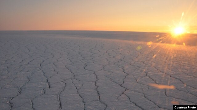
Greenland's ice sheet melts more when it's cloudy.​

Next the scientists performed the same simulations, under clear skies. Clouds enhanced the melt runoff by one-third, compared with clear skies. “Clouds have several effects,” Van Tricht explained. “On the one hand, they help add mass to the ice sheet when it snows. On the other, they have an indirect effect on the ice sheet. Clouds block the sunlight, which lowers the temperature, but at the same time, they form a blanket that keeps the surface warm, especially at night.” A large part of the meltwater is stored in the upper levels of the snowpack, preventing it from draining into the ocean.

Under clear skies at night, the surface gets so cold that a large part of that meltwater refreezes. If it is a cloudy night, the surface is warmer and not as much meltwater can refreeze. Excess meltwater led to an extra 56 billion tons of runoff compared with a scenario without clouds. Greenland is the planet's second-largest ice sheet, after Antarctica. Together they hold approximately 90 percent of the Earth's fresh water. Sea level could rise as much as six meters should Greenland completely disintegrate, putting world coastal communities at enormous risk. “We need to try to understand as many aspects of the climate system as possible so we can do proper predictions,” Van Tricht said. “Our results are one new piece of the puzzle.”

Study: Night Clouds Promote Greenland Ice Melt

See also:

Antarctic Ice May Hide ‘World’s Largest’ Canyon
January 13, 2016 | Researchers say they believe they have found the world’s largest canyon - located under the Antarctic ice.
Writing in the journal Geology, a team of researchers led by Durham University in England says satellite data reveal a possible canyon over 1,000 kilometers long and, in places, one kilometer deep, roughly the same depth as the Grand Canyon in the United States, but much longer. The discovery still “needs to be confirmed by direct measurements,” according to the researchers.

“This is a region of the Earth that is bigger than the UK and yet we still know little about what lies beneath the ice,” said Stewart Jamieson, from the Department of Geography at Durham University. “In fact, the bed of Antarctica is less well known than the surface of Mars. If we can gain better knowledge of the buried landscape, we will be better equipped to understand how the ice sheet responds to changes in climate.”

B19E15E3-C423-48E4-BAA0-A419C03ABB21_w640_r1_s.png

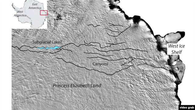
Researchers believe they have found a massive canyon hiding under the Antarctic ice.​

The canyons, which are located in the remote Princess Elizabeth Land ((PEL)) region in East Antarctica, are actually chasms buried under kilometers of ice. Researchers believe the canyons were carved by water, either flowing under the ice or perhaps by water that ran over the area before the ice formed.

While no part of the canyons can be seen, the surface ice does reflect the possible canyons below when using satellite imagery. The group also has identified small parts of the canyons using radio-echo sounding data, meaning radio waves are passed through the ice to map the rocks beneath. Researchers say the canyons may be connected to a massive subglacial lake that could cover up to 1,250 square kilometers. Currently, the team is conducting an airborne survey of the area using radio-echo sounding measurements in order to confirm the canyons’ presence. Those results could be made public later this year.

Here's a short video about the discovery:
 
Frank wrote: Why is it called Greenland

I dunno...

... mebbe it's `cause it was the first Green land...

... the Vikings saw when dey sailed the ocean blue.
 
Frank wrote: Why is it called Greenland

I dunno...

... mebbe it's `cause it was the first Green land...

... the Vikings saw when dey sailed the ocean blue.

hmm it was Green in recent history, riiiiiiiiiiiiiiiiiiight?

Actually yes it was. The Vikings settled it.

Well that can only mean man-made global warming

Yeah, those coal plants and autos around the birth of Christ really did a number on the ecosystem.

I think GISS has the temperature readings from back then, of course accurate to a tenth of a degree
 
Time to start contributing to the environment forum, after all, I'm just another commie enviro liberal fascist. LOL.
Climate Change: Vital Signs of the Planet: The hidden meltdown of Greenland
More than 90 percent of our planet’s freshwater ice is bound in the massive ice sheets and glaciers of the Antarctic and Greenland. As temperatures around the world slowly climb, melt waters from these vast stores of ice add to rising sea levels. All by itself, Greenland could bump sea levels by 7 meters (23 feet) if its ice melted completely.

And … it’s melting.

In August 2014, Eric Rignot, a glaciologist working at the University of California, Irvine and NASA's Jet Propulsion Laboratory, led a team in mapping ice cliffs at the front edges of three outlet glaciers in Greenland. The researchers found cavities that undercut the base of these leading edges that can destabilize the ice front and enhance iceberg calving, the process where parts of the glacier break off and float away.

"In Greenland we have melt rates of a few meters a day in the summer months," says Rignot.

What’s causing this "big thaw"?

Rignot’s team found that Greenland's glaciers flowing into the ocean are grounded deeper below sea level than previously measured. This means that the warm ocean currents at depth can sweep across the glacier faces and erode them.
I read something a ways back about the theory that the melting of the greenland ice pack could shut down of the conveyor currents that bring warm water towards Western Europe. The theory said it could drastically alter Europes climate. I don't know of the validity but it was interesting.
 
The Gulf Stream (actually, all the gyres in all four of the major ocean basins) are driven by the Coriolis force produced by the rotation of the Earth. Warming will not stop them. The "conveyor belts", threatened by the release of large amounts of fresh water into the oceans (near the poles), are the Meridional Overturning Currents (AMOC and PMOC). These are driven by cold, dense salt water sinking at the poles and slowly making its way across the abyssal plains to the equator, where it then wells up, carrying with it minerals
dissolved during its long trip across the bottom. Those minerals feed enormous amounts of equatorial phytoplankton which then feed enormous amounts of zooplankton, then diatoms, then copepods, then wee fish and bigger fish and bigger fish until we have things large enough for humans to catch and feed the hungry. It is also a transport mechanism for an enormous amount of thermal energy and its cessation (from freshwater dilution reducing the density of cold polar waters preventing them from sinking and driving the entire affair) would undoubtedly have significant and complex effects on the world's ocean currents. The impact of that on weather, climate and marine life is impossible to predict (as far as I know).
 
Last edited:
The Gulf Stream (actually, all the gyres in all four of the major ocean basins) are driven by the Coriolis force produced by the rotation of the Earth. Warming will not stop them. The "conveyor belts", threatened by the release of large amounts of fresh water into the oceans (near the poles), are the Meridional Overturning Currents (AMOC and PMOC). These are driven by cold, dense salt water sinking at the poles and slowly making its way across the abyssal plains to the equator, where it then wells up, carrying with it minerals
dissolved during its long trip across the bottom. Those minerals feed enormous amounts of equatorial phytoplankton which then feed enormous amounts of zooplankton, then diatoms, then copepods, then wee fish and bigger fish and bigger fish until we have things large enough for humans to catch and feed the hungry. It is also a transport mechanism for an enormous amount of thermal energy and its cessation (from freshwater dilution reducing the density of cold polar waters preventing them from sinking and driving the entire affair) would undoubtedly have significant and complex effects on the world's ocean currents. The impact of that on weather, climate and marine life is impossible to predict (as far as I know).

Correct me if I'm wrong, but I seem to vaguely remember someone posting a theory of why the Glaciation of the Americas was caused by a major shift in the Gulf Stream.
 
There is an absolutely fascinating book by Jared Diamond, called Collapse, that has a very definative history of the viking settlements in Greenland. I suggest that anyone that wants to comment on that period read it before commenting.
 
Why is it called Greenland?

Eric the Red was banned to Greenland, he named it Greenland in order to attract more settlers to his little kingdom, even though it was colder than Iceland. It was just a misrepresentation, Im sure he thought it was funny as hell. Well, I read this a long time ago.
 
Frank wrote: Why is it called Greenland

I dunno...

... mebbe it's `cause it was the first Green land...

... the Vikings saw when dey sailed the ocean blue.

hmm it was Green in recent history, riiiiiiiiiiiiiiiiiiight?

Actually yes it was. The Vikings settled it.


It has not been particularly green within human history. It was named Greenland in an attempt to get people to come settle the place. Iceland has far more open land and vegetation than Greenland.

From Wikipedia
It was the early Norwegian settlers who gave the country the name Greenland. In the Icelandic sagas, it is said that the Norwegian-born Icelander Erik the Red was exiled from Iceland for manslaughter. Along with his extended family and histhralls, he set out in ships to explore icy land known to lie to the northwest. After finding a habitable area and settling there, he named it Grœnland (translated as "Greenland"), supposedly in the hope that the pleasant name would attract settlers.[1
 
The Gulf Stream (actually, all the gyres in all four of the major ocean basins) are driven by the Coriolis force produced by the rotation of the Earth. Warming will not stop them. The "conveyor belts", threatened by the release of large amounts of fresh water into the oceans (near the poles), are the Meridional Overturning Currents (AMOC and PMOC). These are driven by cold, dense salt water sinking at the poles and slowly making its way across the abyssal plains to the equator, where it then wells up, carrying with it minerals
dissolved during its long trip across the bottom. Those minerals feed enormous amounts of equatorial phytoplankton which then feed enormous amounts of zooplankton, then diatoms, then copepods, then wee fish and bigger fish and bigger fish until we have things large enough for humans to catch and feed the hungry. It is also a transport mechanism for an enormous amount of thermal energy and its cessation (from freshwater dilution reducing the density of cold polar waters preventing them from sinking and driving the entire affair) would undoubtedly have significant and complex effects on the world's ocean currents. The impact of that on weather, climate and marine life is impossible to predict (as far as I know).
Glad to see you finally admit that there's some aspect of the climate that is "impossible to predict"
 
You are wrong.
Really?

"Warm water was there, but deep under the cold, icy surface. So the climate experience was colder, as the atmospheric records from Greenland ice cores show. But what eventually happened, is that the warm water reached a critical point, surged upwards to the surface, and contributed to the abrupt warming of the surface water and atmosphere," says Ezat.

[FONT=Helvetica Neue, Helvetica, Arial, sans-serif]http://www.sciencedaily.com/releases/2014/09/140916084821.htm

I thought I remembered seeing something about it somewhere.
[/FONT]
 

Forum List

Back
Top