Possible Record Cold Coming

Record cold snaps are almost always caused by variations in the jet stream. The stream is fueled by the temperature difference between the northern and southern latitudes. The arctic is warming faster than the tropics. This means less temperature difference (less fuel) and a weaker stream. The weaker stream is more prone to wandering, letting cold arctic air masses come much further south than usual. Poof! Record cold temperatures. The same phenomenon is responsible for record heat waves in Alaska and Canada when the stream wanders north.

That makes sense ... I seem to remember reading a paper about this (do you remember the author's name?) ... these waves in the jet stream would have a higher amplitude and slower progression ... but this is a two-edged sword; inclement weather will be more inclement and last longer, but fair weather will be fairer and again last longer ... these are averages, which produce the larger wandering due to less power (less fuel), but today the Arctic is getting colder than the tropics, returning the power and driving the existing wander further south ... if by chance this has not happened on these dates before, then we set record lows for that date ... the better metric is comparing these lows to the records two weeks fore and aft, closer to a monthly record low ...

I do think you're wrong about the Polar Front being driven further south than usual ... usual means all the way to the Gulf Coast and stopped by the Gulf's sub-tropical waters off-shore ... not that the front doesn't push further, infamously the morning of the Challenger tragedy; although infrequent, still usual ... unusual being snowfall in Havana ...

The corollary to this Arctic Amplification is that it's not just the jet streams that will be weaker, all the large-scale flow patterns will be weaker ... less of a temperature difference weakens the forces driving warm tropical air towards the poles and cold polar air towards the equator ... thus lower average power in the atmosphere ... the probabilities of more powerful weather events become less likely ...

What I like best about your explanation is that not only is it theoretically sound, we have empirical data to back it up ... a case where statistics sends us to the right place to look, and we seemed to have found it ... good science ...
Fairer weather doesn't necessarily last longer, we spend the time swinging between the two extremes. It was °75 degrees here today, unseasonably warm. Admittedly °75 degrees is not an uncomfortable temp, but it is way out of normal for november.

As the pattern gets weaker the weather will get more extreme because the contrasting airmasses are not being separated by the jet stream.


Uhm climate change is not local
Umm..

DUH.


But its fucking cold where you said it would be warm..


So what was the scam ?


.
Ok, if you really can't figure that out I'm afraid I can't help you.


I seen a cute girl wearing carhartts.. it blew me away
 
I've explained how global warming can cause record cold for you denier idiots every time it gets cold.

Do I have to do it again?
Yes indeed, warming can cause cold, just like night can cause day.
I'd explain night and day to you but first you'd have to understand that the Earth is round.
No thank you, I'd rather have it explained to me by whoever explained it to you, that way it won't be distorted.
NOAA.


NOAA my ass just go outside
 
Fairer weather doesn't necessarily last longer, we spend the time swinging between the two extremes. It was °75 degrees here today, unseasonably warm. Admittedly °75 degrees is not an uncomfortable temp, but it is way out of normal for november.

This is what the research claimed ... the jet stream waves will propagate slower around the globe such that troughs and ridges will move slower across the mid latitudes ... sounds like you're in a ridge drawing warm sub-tropical air up north ... I warrant the weather girl has a big "H" over the top of you ...

As the pattern gets weaker the weather will get more extreme because the contrasting airmasses are not being separated by the jet stream.

The jet stream is a product of the contrasting air masses ... the Westerlies in their tightest circle around the globe, pushed up and over the polar front ...

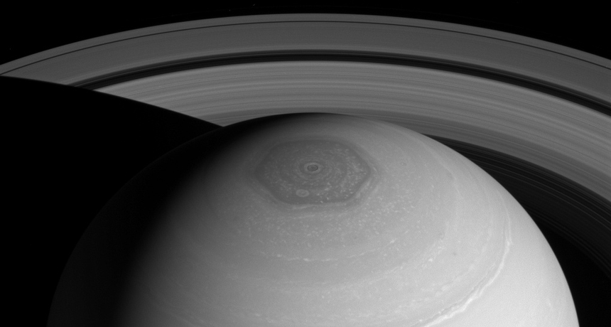
No word yet on why the jet stream forms a fairly regular hexagon on Saturn ...

090518_CC_saturn-vortex_feat.jpg


Just a reminder on how much we don't know ...
 
This is what the research claimed ... the jet stream waves will propagate slower around the globe such that troughs and ridges will move slower across the mid latitudes
But will have higher amplitude. Thus, more instances of frigid polar air over Alabama.
 
No word yet on why the jet stream forms a fairly regular hexagon on Saturn ...
...because testing the hypotheses to explain it is a huge undertaking, requiring space launches and spacecraft. We will figure it out eventually, but it should come as no surprise that we know much more about our own atmosphere than we do about Saturn's.

Well ... we know more about Saturn's atmosphere than you know about Earth's ... that's for sure ...
 

Forum List

Back
Top