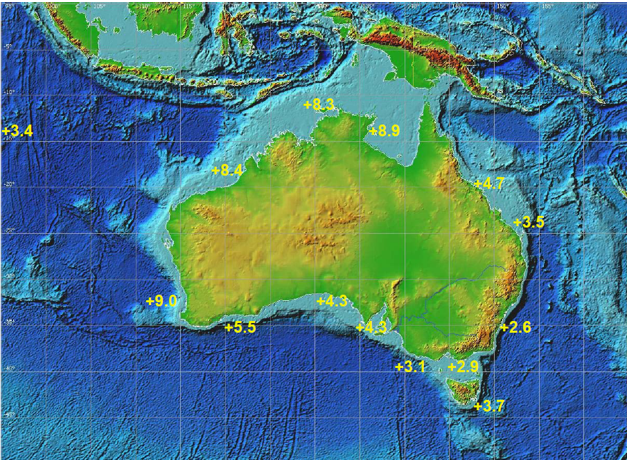
I have not noticed anybody mention the Isle of the Dead and the physical evidence that indicates the level of the Oceans are more or less constant.
In 1841 Captain Sir James Clark Ross, marked the mean level of the sea. It is funny to note, that back in 1841 that people had a better understanding of the Earth and Oceans, that they observed changes in Sea Level dramatic enough, that they determined a need to record a benchmark for future studies.

Tasmanian Sea Levels - Lessons from the Isle of the Dead
Measuring sea-level rise at Port Arthur
150 year old mark shows no ocean rise
I added some links to the OP.
In 1841 Captain Sir James Clark Ross, marked the mean level of the sea. It is funny to note, that back in 1841 that people had a better understanding of the Earth and Oceans, that they observed changes in Sea Level dramatic enough, that they determined a need to record a benchmark for future studies.
Isle of the Dead
The ‘Isle of the Dead’ may yet prove to be another nail in the coffin of global warming and its gruesome companion, Disastrous Sea Level Rises.
The `Isle of the Dead’ is over two acres in size and is situated within the harbor of Port Arthur opening directly to the Southern Ocean. The isle itself is actually a graveyard (thus its eerie name), containing the graves of some 2,000 British convicts and free persons from the 19th century who lived and died at the nearby convict colony of Port Arthur between 1832 and 1870.
In 1841. renowned British Antarctic explorer, Captain Sir James Clark Ross, sailed into Tassy after a 6-month voyage of discovery and exploration to the Antarctic.
Ross and Governor Franklin made a particular point of visiting Port Arthur, to meet Thomas Lempriere, a senior official of the convict colony there, but who was also a methodical observer and recorder of meteorological, tidal, and astronomical data. It is important to note what Captain Ross wrote about it.
“My principal object in visiting Port Arthur was to afford a comparison of our standard barometer with that which had been employed for several years by Mr. Lempriere, the Deputy Assistant Commissary General, in accordance with my instructions, and also to establish a permanent mark at the zero point, or general mean level of the sea as determined by the tidal observations which Mr. Lempriere had conducted with perseverance and exactness for some time: by which means any secular variation in the relative level of the land and sea, which is known to occur on some coasts, might at any future period be detected, and its amount determined.
The point chosen for this purpose was the perpendicular cliff of the small islet off Point Puer, which, being near to the tide register, rendered the operation more simple and exact. The Governor, whom I had accompanied on an official visit to the settlement, gave directions to afford Mr. Lempriere every assistance of labourers he required, to have the mark cut deeply in the rock in the exact spot which his tidal observations indicated as the mean level of the ocean.
That mark is still there today, as can be seen in the photo.The photo was taken at midway between high and low tides.
There is intensive research presently underway by several institutions including the now corrupt CSIRO assisted by the head of the Inter-Agency Committee on Marine Science & Technology, Dr David Pugh, who is based at the University of Southampton, UK. But in spite of plenty of time we have yet to see their detailed explanation of just why this mark confounds all the predictions about sea level rise.
Dr. Pugh airily waves his hands and says in effect that poor old confused Lempriere, in spite of the detailed instructions about getting a Mean Sea Level (half way between high and low tide), he just put in the high water mark. This, of course, sounds logical to anybody steeped in the Green religion.
But not to anyone else and not to real scientists who look at evidence unflinchingly.
Tasmanian Sea Levels - Lessons from the Isle of the Dead
Measuring sea-level rise at Port Arthur
150 year old mark shows no ocean rise
I added some links to the OP.
Last edited by a moderator: