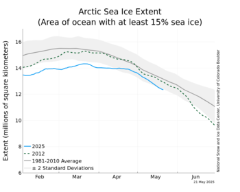
2016 Arctic sea ice thread

For anyone following LaDumkopfs stupidity, simply go to Google Earth, and look at the Marshal Islands. The nearest subduction zone is many hundreds of miles away. In fact, the nearest major tectonic feature is the Victoria Fracture Zone. People making such idiotic assertations that are so easy to check, should realize that they are soon labeled as idiots by all.
So, are the Marshall Islands really an island or an Atoll? Do you know what an Atoll is? What makes up the ring of fire? Hmmmmmm Volcanoes, now when you learn what an Atoll is then ask how the Marshall Islands aren't part of the ring of fire. Thanks for playing.
 
So you and Billy Bob think volcanoes only occur on the Ring of Fire. Aren't you two the geological experts.
 
Well now, jc, I will explain this as carefully as I can, allowing for your retardation.

Volcanoes occur in areas that are very far from any subduction zone. Especially in the ocean, because of the very much thinner crust. However, if you really want to check that out, use Google Earth. Just click on Google Earth, put Marshal Islands in the box in the upper left hand corner, and zoom in and out. You can see quite clearly where the trenchs are, and there are no such near the Marshal Islands.
I did and the facts are mine and the other posters.
 
So, you are claiming that the Marshal Islands are sitting over a subduction zone? LOL


I'll go even further - ALL of the warmers' "sinking islands" are right on the lip of the Ring of Fire and are sinking because of subduction, which has a substantial range from the actual fault. In the beginning of the subduction, the angle of descent is quite small, but enough for islands to notice their homes are sinking. This can start more than 100 miles from the fault.

The reason all the "sinking islands" are right on top of the PROF is very simple...

THE WARMERS HAVE NO ACTUAL REAL SEA LEVEL RISE
 
So you and Billy Bob think volcanoes only occur on the Ring of Fire. Aren't you two the geological experts.

The majority are. Do you question that?

I know what the Ring of Fire is and have a basic understanding of volcanoes. For the comment you made and for which Billy Boy gave you the high-five to have any validity, it would require that all volcanoes be on the Ring of Fire. Once more, you people demonstrate your ignorance of basic science.
 
Last edited:
LOL!!!

Crick spins and lies like the taxpayer funded "climate bullshitter" he is.

The Ring is all about the bottom of the Pacific Ocean being pushed under adjacent plates because the Pacific Ocean is shrinking and that bottom plate has to go somewhere. If you live on an island right on the lip of the PROF, your land is toast, and the US taxpayer is not liable, despite what Crick and Obama say.
 
So you and Billy Bob think volcanoes only occur on the Ring of Fire. Aren't you two the geological experts.

The majority are. Do you question that?

I know what the Ring of Fire is and have a basic understanding of volcanoes. For the comment you made and for which Billy Boy gave you the high-five to have any validity, it would require that all volcanoes be on the Ring of Fire. Once more, you people demonstrate your ignorance of basic science.
Why? Cause you can't prove the Marshall Islands aren't on it?

When one like you has nothing just blurt out something. LOL
 
Incredibly stupid.

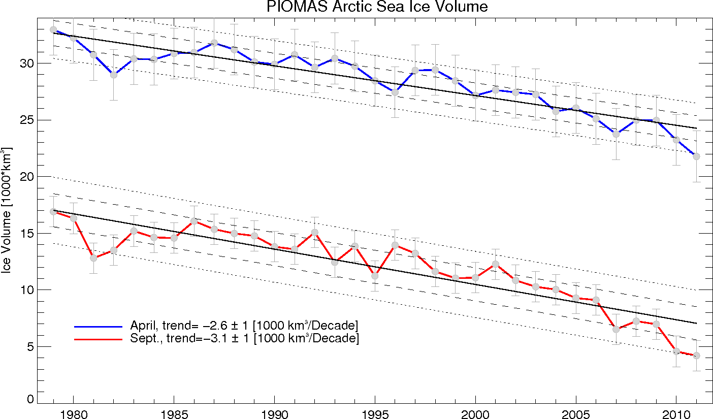
piomas-trnd6.png

piomas-trnd2.png

piomas_icevolexpfit_2012.gif

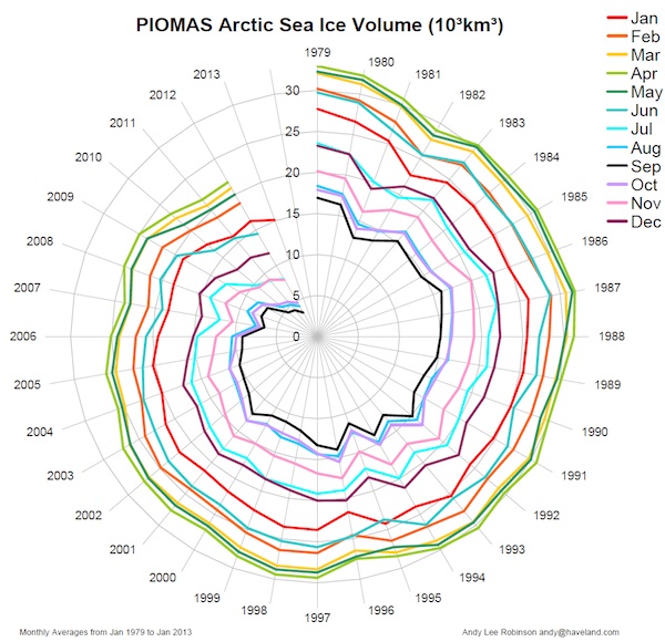
PIOMAS_Spiral.jpeg

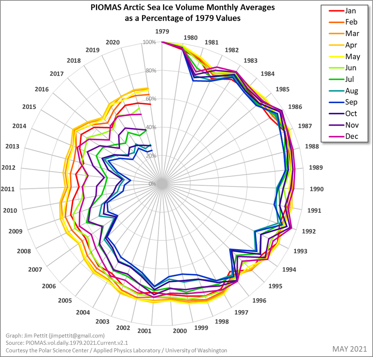
siv_monthly_average_percentage_of_79_polar.png

for_rc_fig1.png

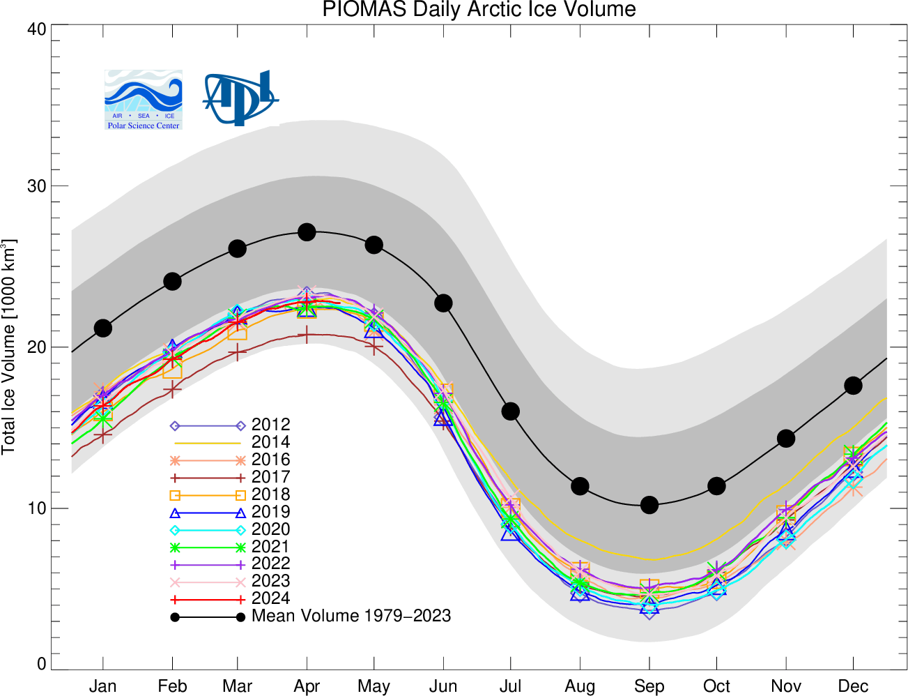
BPIOMASIceVolumeAnomalyCurrentV2.1_CY.png
 
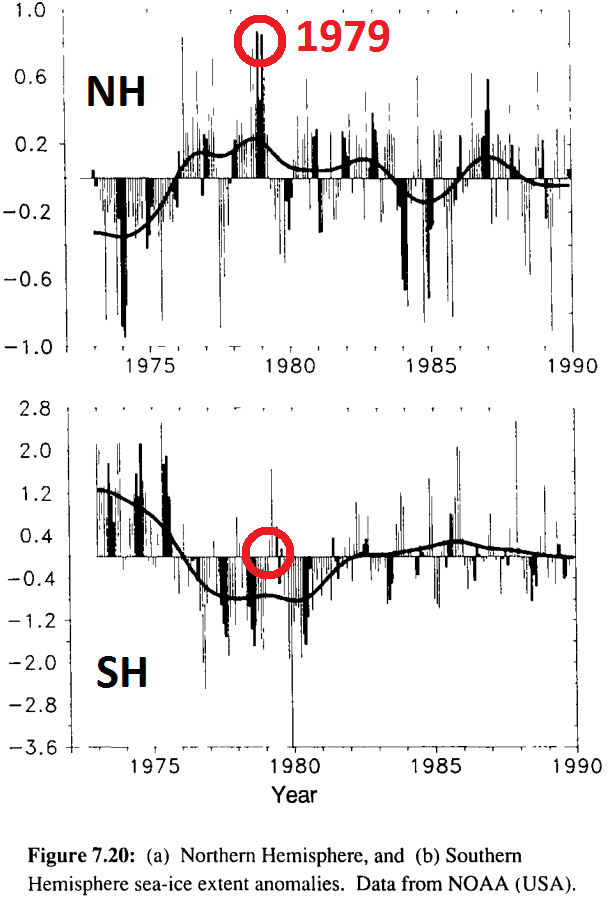
satellite coverage of Arctic Ice extent was available before the full coverage implimented in 1979.

ipcc_far_pp224-225_sea_ice2_1979circled.png


arctic_sea_ice_1971-2012_c2day_and_ipcc.png


the use of polynomial curves on ice extent starting at the maximum and ignoring the cyclical nature of ice is propaganda.

I couldnt easily find the graph with curves with all the months but SkS posted this one-

6a0133f03a1e37970b015435378c39970c-pi


does anyone actually believe that the Arctic will be ice free in 20 years?????? in the middle of winter????? how fucking stupid is that?

if a mathematical model gives you absurd results then you should find a better method, not publicize the ridiculous results to alarm mathematically illiterate viewers who assume that it MUST be true if an 'expert' says so.
 
Ian, that is fucking stupid. You know damned well what that curve means. It does not mean that where the curve hits the zero mark there is going to be an ice free Arctic Ocean. What it does mean, within the plus and minus of the dots on the graph, by the data, that is the most likely time for that to happen. And there is absolutely nothing in that graph that indicates cyclic activity. In fact, there is a definate downward trend.,
 
Oh Gawd with the sea ice graphs. Its 2016......nobody cares. The people have seen these spectacular predictions of no more sea ice for a couple of decades now and now the ice is growing.

Please.........Id like an alarmist to show us where the regular American is giving a fuck about the arctic ice?

Oh and ummm........links please!!:coffee:
 
The polar bears are fine, the penguins are happy, the scientists are busy redefining what the definition of ice is, so they do not have to report there is plenty of ice.
 

Forum List

Back
Top