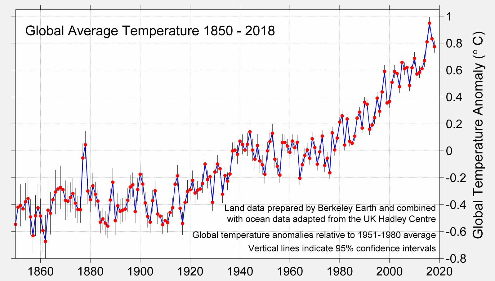
What physical evidence supports the contention that carbon dioxide emissions from burning fossil fuels are the principal cause of global warming since 1970?
If you have it....lets see it. If you don't....then lets hear your best excuse for not providing it.
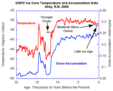
You have missed the point as 1970 has no relevance. The current warming trend began 20000 years ago
Of course anyone who has looked at the data knows that...The people who the thread was directed at don't...they apparently believe that global warming started in 1970 and that we are responsible...and I doubt that you could convince them otherwise...I simply asked for the physical data that supports their belief...
In either event, they are going to believe what they believe primarily because they are so uneducated, that they can't begin to examine the data and instead simply place their faith in someone who is on their side politically.
This really isn't for them...it is for the fence sitters who actually can look at information and form an informed opinion...they see the data...and they see the abject idiocy of those who believe in AGW, and the weakness of the "data" they present...it is good to be able to see how strong one side of an argument is and compare it to how weak the other is.
Looking at data that does not show that half the USA and all of Canada was covered in 1000 to 2000 feet of ice 20000 years ago when the current warming trend began is just simply moronic, like you.
Name 1 prediction that Al Gore made that has turned out to be correct?
Actually since snow is still quite real don't bother
As for asking for evidence beginning in 1970 you either are a AGW fool or have fallen into their trap

Laurentide Ice Sheet
From Wikipedia, the free encyclopedia
(Redirected from
Laurentide ice sheet)
Jump to navigation Jump to search
The
Laurentide Ice Sheet was a massive
sheet of ice that covered millions of square kilometers, including most of
Canada and a large portion of the northern
United States, multiple times during the
Quaternary glacial epochs, from 2.588 ± 0.005 million years ago to the present.
[1]
The last advance covered most of northern North America between c. 95,000 and c. 20,000 years before the present day and, among other geomorphological effects, gouged out the five
Great Lakes and the hosts of smaller lakes of the
Canadian Shield. These lakes extend from the eastern
Northwest Territories, through most of northern Canada, and the upper Midwestern United States (
Minnesota,
Wisconsin, and
Michigan) to the
Finger Lakes, through
Lake Champlain and
Lake George areas of New York, across the northern
Appalachians into and through all of
New England and
Nova Scotia.
At times, the ice sheet's southern margin included the present-day sites of northeastern coastal towns and cities such as
Boston and
New York City and Great Lakes coastal cities and towns as far south as
Chicago and
St. Louis, Missouri, and then followed the present course of the
Missouri River up to the northern slopes of the
Cypress Hills, beyond which it merged with the
Cordilleran Ice Sheet. The ice coverage extended approximately as far south as 38 degrees latitude mid-continent.
[2]