new type of dam that doesn't back up the river

trevorjohnson83

VIP Member
Nov 24, 2015
740
95
88
This new type of dam is based on the idea that surface area of the earth can be shaped so that the river doesn't back up. The dam can be built at any point in any river. What you do is build a typical dam and on the other side of the dam excavate the land so that you widen the river. River current can then be re directed and would run faster at a shallow rate. So instead of water getting backed up by a typical dam, the water runs right through the pipes in the pictures and you can take energy out of the current by changing the surface area resistance of the earth.
 

Attachments

  • a.jpg
    a.jpg
    65.3 KB · Views: 39
This new type of dam is based on the idea that surface area of the earth can be shaped so that the river doesn't back up. The dam can be built at any point in any river. What you do is build a typical dam and on the other side of the dam excavate the land so that you widen the river. River current can then be re directed and would run faster at a shallow rate. So instead of water getting backed up by a typical dam, the water runs right through the pipes in the pictures and you can take energy out of the current by changing the surface area resistance of the earth.

Have you ever taken a class in physics? You obviously have not or you would know your stupid idea does not work.
 
The dam would back up as you take energy out of it but would be in ratio with the added energy from widening the surface area resistance of the river.
 
In the valleys where the water flows along the lowest area, the rivers have hills on both sides. If you started cutting into the hills to widen the river the portion of the hill that is left would begin to erode and the river would end up claiming large areas of ground, and communities whose businesses rely on being next to the river. It would eat up the highways and railroads immediately adjacent to the river used for transporting the goods from the barges onto trucks and train cars to transport to other locations. Some boats pull right up to the factories they deliver to and unload right at the site. Shallow edges would prevent that.
The cost would end up being monstrous and far out way any gain...
 
Last edited:
Various schemes have been tried to harness river currents but none of them are nearly as good as the power of falling water as in a normal hydroelectric dam. Most dams were built to control flooding or to create a reservoir in addition to electricity. Nearly all our rivers have been tamed. There has not been a major dam built in decades.
 
Many of the largest northern lakes in MN were purposefully backed up at rivers to increase the surface area of the lake to provide better floating for logs that were transported to the many lumberyards and paper mills, also to provide hydroelectric power. This all happened a century ago at the Laurentian Divide. Those dams are still in place and control the flow rate north into Canada and eventually to Hudson Bay.
The other two divides include controlled waterways from Lake Superior going east through the Great Lakes eventually going to the Atlantic. The last being the Mississippi watershed heading south.
These dams forever changed the maps, but with them we literally have a Seaport in the middle of the continent in Duluth and access for barges in Mpls heading to the Gulf of Mexico.
These reservoirs are also used by recreational boaters and towns for drinking water. They opened up channels into areas that were inaccessible year round.
I see it all as an engineering marvel.
 
This new type of dam is based on the idea that surface area of the earth can be shaped so that the river doesn't back up. The dam can be built at any point in any river. What you do is build a typical dam and on the other side of the dam excavate the land so that you widen the river. River current can then be re directed and would run faster at a shallow rate. So instead of water getting backed up by a typical dam, the water runs right through the pipes in the pictures and you can take energy out of the current by changing the surface area resistance of the earth.

What makes you think that dams have to raise the level of a waterway?

That has never been the case. Heck, I have been to Swan Falls Dam in Idaho many times, and it is over 100 years old. The first dam across the Snake River in Idaho, it does not raise the water level at all, it simply provides power from the flow of the river.

536adfc967103.image.jpg


However, such dams are nowhere as efficient as gravity fall dams, as the amount of energy in the actual flow of a river is nowhere near as much as the fall such water takes in a conventional sequestration dam and turbine configuration.

And another variant is the power plants at Niagara Falls. Which has power plants that use a similar principal, removing some water from the Niagara River above the falls, and generating power in the drop it would make going over the falls by passing it through turbines and pipes.

But most dams are made for one of two reasons. Either for flood control purposes, or to sequester water for other purposes in dry seasons (normally drinking or irrigation). The simple fact that they can be used to provide power is secondary, and sometimes they never have turbines installed (or installed decades later).
 
Surface area has no impact on a river's flow rate. Look at the Rio Grande. In places it is very shallow but has an increased current when compared to the deeper channels. How is surface area affecting that current when it is wider in the deeper channels?
Well water in the middle of the river actually slides along the water on the outsides which is slower. So I imagine in deeper channels the water has more to slide on if that makes since. Also boulders in the river are a resistance that slows the water down in one spot and speeds it up elsewhere. But rivers will run faster over high levels in the bed.
 
Well water in the middle of the river actually slides along the water on the outsides which is slower. So I imagine in deeper channels the water has more to slide on if that makes since. Also boulders in the river are a resistance that slows the water down in one spot and speeds it up elsewhere. But rivers will run faster over high levels in the bed.

The two things that matter most is the flow rate, and the width of the passage.

The flow rate is roughly the horsepower it is capable of generating. And the width tells how much equipment must be used to capture that flow. This is why high flow but narrower waterways are preferred for power generation, as they can provide more flow to sustain that generation. But this can be circumvented entirely, so long as there is somewhere to sequester the water instead.

But the big downside is that outside of a few larger rivers (Mississippi, Columbia), that flow is very seasonal. For example, the Sacramento River in California can vary from over 40k cubic feet per second (cfs) in the early Spring, all the way down to about 12k cfs in late Autumn. I used to drive over that river every day, and the difference in seasons could be striking. One month only a small flow in the center of the channel and wide banks on both sides. Then just two months later almost cresting the dikes on both sides that keep it contained.


Above is a great example of this. The "Yolo Bypass", just west of Sacramento. That is I-80 that is running through the center. In total, just under 60,000 acres, and the water in that basin will average from 15-20 feet in the Spring. All that water you see, come March it will be dry, and most of it is actually farmland.

smogW-1024x418.jpg


Roughly the same place in the late Spring, looking to the East. That is Downtown Sacramento in the background. Flooding was such a problem in that city since it was founded, that the Army Corps of Engineers came up with that solution to help stop it. That is why the city comes to an abrupt end to the West, and all growth is in the other three directions.

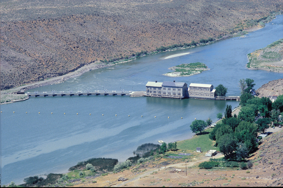
And remember, a lot of that water comes from the Feather River. That is the river the Oroville Dam sits on, and almost failed 4 years ago. And those of us that live in the area are used to seeing the think almost full in the early Spring, and damned near empty by October. A lot of water flows annually down that river, but mostly in just a few months unless it was sequestered.

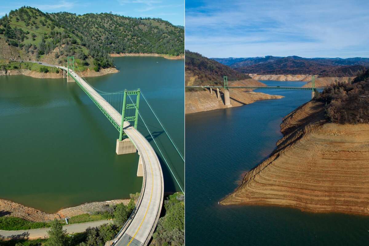
We laugh almost every year, because that is often where the news agencies take their photographs to show how bad the drought is. Normally in summer, after a lot of the water had been released for irrigating the Spring crops. This is a typical view of the Bidwell Bar Bridge The left image is typical spring, notice the green plants everywhere. Then the right is late summer, notice how brown everything is, and how low the water is.

1200x0.jpg


And this is probably in July, because in August-September the reservoir is almost empty. Both to provide as much area as possible to save water come winter, and to provide enough flow for the salmon that are migrating at that time. By late Fall, that will be damned near to the original river bed, as unless there is enough flow the salmon can not make it upstream.
 
Here's another type of dam.

Evaluation of dams as a recharge method: International ...

May 02, 2007 · Dams are used for recharge purposes in many parts of Saudi Arabia. In spite of the importance of such a method, no detailed study exists on its performance. As a part of a comprehensive research project dealing with all aspects of dams as a recharge tool in
 
Here's another type of dam.

It's known as "Pumped Storage Hydropower". It's nothing new, and has been used for over a century. Basically one dam above another. During times of peak use, it drains water to the lower reservoir to generate power. In off-peak hours, it pumps part of the water back up to the top reservoir. I-5 north of LA runs right past one of the most well known ones in the US. To the north is Pyramid Lake, which feeds into Castaic Lake. In the day, water is sent to Castaic to generate power. Then at night, it is pumped right back up into Pyramid Lake.
 
It's known as "Pumped Storage Hydropower". It's nothing new, and has been used for over a century. Basically one dam above another. During times of peak use, it drains water to the lower reservoir to generate power. In off-peak hours, it pumps part of the water back up to the top reservoir. I-5 north of LA runs right past one of the most well known ones in the US. To the north is Pyramid Lake, which feeds into Castaic Lake. In the day, water is sent to Castaic to generate power. Then at night, it is pumped right back up into Pyramid Lake.

There are 300 of them in Arabia to capture ground water.
 
There are 300 of them in Arabia to capture ground water.

That is the purpose of the majority of dams in the US. Both Pyramid and Castaic primarily use water from the California aqueduct.

Power generation is a secondary use of most dams in the US. The vast majority are for water sequestration and/or flood control.
 
That is the purpose of the majority of dams in the US. Both Pyramid and Castaic primarily use water from the California aqueduct.

Power generation is a secondary use of most dams in the US. The vast majority are for water sequestration and/or flood control.
Why not just build dry dams, allowing only farming in the areas subject to emergency periodic flooding. that's old school, it's cheaper and less restrictive.
 

Forum List

Back
Top