EMH
Diamond Member
- Apr 5, 2021
- 33,490
- 19,540
- 2,788
This specific issue has derailed many other threads because my opponent is a factless spazzed out "faux skeptic" funded by the Co2 FRAUD and obsessed with shouting down the truth.
ALL LAND within 600 miles of an Earth pole is IN ICE AGE. What happens when land moves within approximately 600 miles = the annual snowfall ceases to fully melt in the summer, and hence starts to stack. That stacking is the start of an ice age and ice ages are continent specific, because glaciers, even 2.5 miles thick, break off in ocean water, they do not grow out and over deep ocean to the next continent.
Where is Earth ice today?
90% is on land mass Antarctica
7% is on land mass Greenland

This really isn't that hard. Land moves tectonically. Greenland has been moving NW and just recently arrived in the 600 miles to the pole zone. The advance of Greenland's ice, north to south, is well documented.
Northernmost Greenland was completely green 2 million years ago...
 www.nature.com
Center of Greenland went from forest to ice age 450-800k years ago
 www.livescience.com
Advance of Greenland's ice age finished off the Viking settlement on the southern tip in the 1400s
All of that gives us data. How fast is an ice age? It moves about a mile every thousand years aka GLACIAL SPEED.
Ice cores document the stacking and age of the upper layers. They also document that the ice has grown EVERY YEAR, including during the Co2 FRAUD's bogus "interglacials." Greenland has 130k years of useful ice core data, Antarctica has 800k. What Ding and the Co2 FRAUD push is the laughable concept that 2.5 mile thick glacier on or near Chicago was only 75k years old, "Milankovich cycles" already busted here...

 www.usmessageboard.com
and here
 www.usmessageboard.com
It is not hard to understand Earth climate change. Each polar area is essentially an Earth AC unit that cools both air and water. Antarctica is 50F colder than Arctic, meaning air that passes over AA cools more than air that passes over Arctic. AA dumps 9 times the ice of the Arctic into the oceans, some 46 times the molecular H2O the Mississippi dumps in the Gulf every year. AA cools the oceans more than Arctic.
If Earth had two polar oceans, it would have no ice, higher surface air pressure, higher oceans, it would be warmer and canes would be bigger and stronger
If Earth had two polar continents, two Antarcticas, it would have more than double the ice, lower oceans, lower surface air pressure, and little to no cane activity.
and we know this from Jurassic about two polar oceans...
From Google...
During the Jurassic Period, the Earth's climate was much warmer and wetter than it is today.
The atmospheric pressure during the Jurassic period was likely significantly higher than it is today, at least 3.2–5.0 bar compared to the current 1 bar.
Now, the side arguing ocean currents are responsible for "glaciation" well...
1. they do not have any data. What were oceans currents doing 50, 100, 1000 years ago? They have NO IDEA, NO DATA
2. they cannot refute 600 miles to the pole
3. they accept Milankovich and hence all of its falsehoods documented in the links above
4. they, really we the American taxpayer, pay morons like Ding to troll and cut and paste fudged fraud
5. their 800k global temp chart is really about Oxygen isotopes, not temperature, and hence is, at best, not controlled and certifiably DIRTY "data" if it isn't outright fudged fraud. A big volcano changes Earth's Oxygen isotope ratio, and there is no way to "correct" for that. The data is trash.
So instead of turning every thread into this debate, keep it here...
ALL LAND within 600 miles of an Earth pole is IN ICE AGE. What happens when land moves within approximately 600 miles = the annual snowfall ceases to fully melt in the summer, and hence starts to stack. That stacking is the start of an ice age and ice ages are continent specific, because glaciers, even 2.5 miles thick, break off in ocean water, they do not grow out and over deep ocean to the next continent.
Where is Earth ice today?
90% is on land mass Antarctica
7% is on land mass Greenland
This really isn't that hard. Land moves tectonically. Greenland has been moving NW and just recently arrived in the 600 miles to the pole zone. The advance of Greenland's ice, north to south, is well documented.
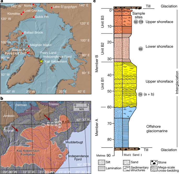
Northernmost Greenland was completely green 2 million years ago...
A 2-million-year-old ecosystem in Greenland uncovered by environmental DNA - Nature
Analysis of two-million-year-old ancient environmental DNA from the Kap København Formation in North Greenland shows there was an open boreal forest with diverse plant and animal species, of which several taxa have not previously been detected at the site, representing an ecosystem that has no...
www.nature.com
Center of Greenland went from forest to ice age 450-800k years ago
Ancient Greenland Was Actually Green
Greenland was once carpeted in lush forests, a new study shows.
www.livescience.com
Advance of Greenland's ice age finished off the Viking settlement on the southern tip in the 1400s
All of that gives us data. How fast is an ice age? It moves about a mile every thousand years aka GLACIAL SPEED.
Ice cores document the stacking and age of the upper layers. They also document that the ice has grown EVERY YEAR, including during the Co2 FRAUD's bogus "interglacials." Greenland has 130k years of useful ice core data, Antarctica has 800k. What Ding and the Co2 FRAUD push is the laughable concept that 2.5 mile thick glacier on or near Chicago was only 75k years old, "Milankovich cycles" already busted here...
How old were the 2.5 mile thick glaciers covering Chicago in the past 20k-5 million years?
This is where the climate debate is now stuck. Every piece of land within 600 miles of a pole is in ice age, everything outside of that is not. Nobody has attempted to dispute that. It is the clear truth of Earth today. Milankovitch Cycles, which I call McBullshit Cycles, take a very...
www.usmessageboard.com
and here
The lies of Milankovich Cycles aka McBullshit - where was land mass Antarctica 70 million years ago
McBullshit claims Antarctica has been on the South Pole forever, it never moved at all. And, while it is on the South Pole, it has rapidly gone from ice age to tropical paradise and back over and over.... a Dennis Quaid theory for sure... We know that Antarctica has 70 million year old...
www.usmessageboard.com
It is not hard to understand Earth climate change. Each polar area is essentially an Earth AC unit that cools both air and water. Antarctica is 50F colder than Arctic, meaning air that passes over AA cools more than air that passes over Arctic. AA dumps 9 times the ice of the Arctic into the oceans, some 46 times the molecular H2O the Mississippi dumps in the Gulf every year. AA cools the oceans more than Arctic.
If Earth had two polar oceans, it would have no ice, higher surface air pressure, higher oceans, it would be warmer and canes would be bigger and stronger
If Earth had two polar continents, two Antarcticas, it would have more than double the ice, lower oceans, lower surface air pressure, and little to no cane activity.
and we know this from Jurassic about two polar oceans...
From Google...
During the Jurassic Period, the Earth's climate was much warmer and wetter than it is today.
The atmospheric pressure during the Jurassic period was likely significantly higher than it is today, at least 3.2–5.0 bar compared to the current 1 bar.
Now, the side arguing ocean currents are responsible for "glaciation" well...
1. they do not have any data. What were oceans currents doing 50, 100, 1000 years ago? They have NO IDEA, NO DATA
2. they cannot refute 600 miles to the pole
3. they accept Milankovich and hence all of its falsehoods documented in the links above
4. they, really we the American taxpayer, pay morons like Ding to troll and cut and paste fudged fraud
5. their 800k global temp chart is really about Oxygen isotopes, not temperature, and hence is, at best, not controlled and certifiably DIRTY "data" if it isn't outright fudged fraud. A big volcano changes Earth's Oxygen isotope ratio, and there is no way to "correct" for that. The data is trash.
So instead of turning every thread into this debate, keep it here...


