Israeli settlers set fire, Israel initially blamed Palestinians.

SobieskiSavedEurope

Gold Member
Apr 13, 2017
25,611
1,200
290
Putnam Lake, NY raised, Pawling, NY resident.
Yeah, it's just Palestinians, the boogie-man of Israel.

Israeli army blamed Palestinians for arson by settlers. Then a video emerged

Israeli Army Blamed Palestinians for Arson by Settlers. Then a Video Emerged

The Israeli military had originally claimed that only Palestinians set fire to West Bank fields, but changed versions after video released by NGO B'Tselem showed otherwise


Yotam Berger
May 23, 2019 11:22 AM
4comments Subscribe now
1.7278053.2647950280.png

One of the settlers seen setting fields on fire in B'Tselem's documentation.B'Tselem / Screengrab
Israeli soldiers stand by as settlers pelt Palestinians with rocks[/paste:font]
The Israeli military admitted on Thursday that Jewish settlers set West Bank fields on fire last Friday, changing its version after it originally blamed the arson on Palestinians.

>> Subscribe for just $1 now

The Israel Defense Forces' Spokesperson's Unit confirmed that settlers, too, were responsbile for the blazes after Israeli human rights nonprofit organization B'Tselem published on Wednesday a video clip that shows that the settlers took part in igniting the fires.
 
RE: Israeli settlers set fire, Israel initially blamed Palestinians.
⁜→ fncceo, et al,


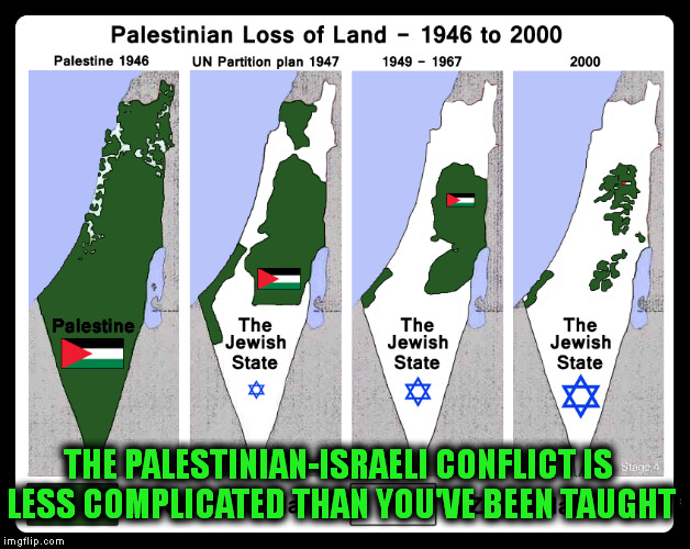
It becomes more complicated when you flood the argument with obvious propaganda lies like the map above.

In fact, Israel today is half the size that it was in 1967.
(COMMENT)

The FIRST of the four maps is mislabled. It was not "Palestine" as in the State of. Instead, in 1946, it was, (by the definition of the Palestine Order in Council): "The limits of this Order are the territories to which the Mandate for Palestine applies, hereinafter described as Palestine." This territory under the Mandate for Palestine was not an Arab Self-Governing. In fact the Arab Palestines declined all invitations to participate in the development of self-governing institutions.

The SECOND of the four maps. in 1947, while the UNSCOP recommended a partition plan, it was not effective until May 1948. And then, only the Jewish State portion was implemented since the Arab Palestinians rejected the aportionment. So the GREEN in the SECOND Map was really UN charter artcle77 Trustee Territory.

The THIRD Map is mislabled in two respects: 1) The West Bank was actually Territory Occupied by the Jordanians. 2) The Gaza Strip was actually Territory Occupied by the Egyptians.

The FOURTH Map is totally screwed-up. It should look like the THIRD Map with the GREEN Territory labeled as Occupied by the Israelis and subject to the implemented by Oslo Accords.​

What can I say, we've all seen this map sequence, and many have fallen prey to the Arab Palestinian Propaganda labeling and exploitation of it. But very few take the time to critically evaluate the implications and factual presentation.

Most Respectfully,
R
 
The Muslim terrorists learned about FAKE NEWS from our party of INFANTICIDE... They also only fire rockets into Israel after the Jews shoot at them...ROTFLMFAO
 
RE: Israeli settlers set fire, Israel initially blamed Palestinians.
⁜→ fncceo, et al,


It becomes more complicated when you flood the argument with obvious propaganda lies like the map above.

In fact, Israel today is half the size that it was in 1967.
(COMMENT)

The FIRST of the four maps is mislabled. It was not "Palestine" as in the State of. Instead, in 1946, it was, (by the definition of the Palestine Order in Council): "The limits of this Order are the territories to which the Mandate for Palestine applies, hereinafter described as Palestine." This territory under the Mandate for Palestine was not an Arab Self-Governing. In fact the Arab Palestines declined all invitations to participate in the development of self-governing institutions.

The SECOND of the four maps. in 1947, while the UNSCOP recommended a partition plan, it was not effective until May 1948. And then, only the Jewish State portion was implemented since the Arab Palestinians rejected the aportionment. So the GREEN in the SECOND Map was really UN charter artcle77 Trustee Territory.

The THIRD Map is mislabled in two respects: 1) The West Bank was actually Territory Occupied by the Jordanians. 2) The Gaza Strip was actually Territory Occupied by the Egyptians.

The FOURTH Map is totally screwed-up. It should look like the THIRD Map with the GREEN Territory labeled as Occupied by the Israelis and subject to the implemented by Oslo Accords.​

What can I say, we've all seen this map sequence, and many have fallen prey to the Arab Palestinian Propaganda labeling and exploitation of it. But very few take the time to critically evaluate the implications and factual presentation.

Most Respectfully,
R

Thank you for the information. And the clarification.
 
RE: Israeli settlers set fire, Israel initially blamed Palestinians.
⁜→ fncceo, et al,


It becomes more complicated when you flood the argument with obvious propaganda lies like the map above.

In fact, Israel today is half the size that it was in 1967.
(COMMENT)

The FIRST of the four maps is mislabled. It was not "Palestine" as in the State of. Instead, in 1946, it was, (by the definition of the Palestine Order in Council): "The limits of this Order are the territories to which the Mandate for Palestine applies, hereinafter described as Palestine." This territory under the Mandate for Palestine was not an Arab Self-Governing. In fact the Arab Palestines declined all invitations to participate in the development of self-governing institutions.

The SECOND of the four maps. in 1947, while the UNSCOP recommended a partition plan, it was not effective until May 1948. And then, only the Jewish State portion was implemented since the Arab Palestinians rejected the aportionment. So the GREEN in the SECOND Map was really UN charter artcle77 Trustee Territory.

The THIRD Map is mislabled in two respects: 1) The West Bank was actually Territory Occupied by the Jordanians. 2) The Gaza Strip was actually Territory Occupied by the Egyptians.

The FOURTH Map is totally screwed-up. It should look like the THIRD Map with the GREEN Territory labeled as Occupied by the Israelis and subject to the implemented by Oslo Accords.​

What can I say, we've all seen this map sequence, and many have fallen prey to the Arab Palestinian Propaganda labeling and exploitation of it. But very few take the time to critically evaluate the implications and factual presentation.

Most Respectfully,
R
The THIRD Map is mislabled in two respects: 1) The West Bank was actually Territory Occupied by the Jordanians. 2) The Gaza Strip was actually Territory Occupied by the Egyptians.
Since you can only occupy sovereign territory, whose sovereign territory did Egypt and Jordan occupy?

What territory? Egypt and Jordan “ occupied “ Gaza, the W. Bank and E. Jerusalem; areas that were Formally recognized as legal territories by the International community.
Apparently he never heard of the 67 War the Arabs initiated in the goal to occupy and destroy Israel with the U. N. actually aiding them by leaving the area just prior to the War. .
 
Last edited:
RE: Israeli settlers set fire, Israel initially blamed Palestinians.
⁜→ fncceo, et al,


It becomes more complicated when you flood the argument with obvious propaganda lies like the map above.

In fact, Israel today is half the size that it was in 1967.
(COMMENT)

The FIRST of the four maps is mislabled. It was not "Palestine" as in the State of. Instead, in 1946, it was, (by the definition of the Palestine Order in Council): "The limits of this Order are the territories to which the Mandate for Palestine applies, hereinafter described as Palestine." This territory under the Mandate for Palestine was not an Arab Self-Governing. In fact the Arab Palestines declined all invitations to participate in the development of self-governing institutions.

The SECOND of the four maps. in 1947, while the UNSCOP recommended a partition plan, it was not effective until May 1948. And then, only the Jewish State portion was implemented since the Arab Palestinians rejected the aportionment. So the GREEN in the SECOND Map was really UN charter artcle77 Trustee Territory.

The THIRD Map is mislabled in two respects: 1) The West Bank was actually Territory Occupied by the Jordanians. 2) The Gaza Strip was actually Territory Occupied by the Egyptians.

The FOURTH Map is totally screwed-up. It should look like the THIRD Map with the GREEN Territory labeled as Occupied by the Israelis and subject to the implemented by Oslo Accords.​

What can I say, we've all seen this map sequence, and many have fallen prey to the Arab Palestinian Propaganda labeling and exploitation of it. But very few take the time to critically evaluate the implications and factual presentation.

Most Respectfully,
R
The THIRD Map is mislabled in two respects: 1) The West Bank was actually Territory Occupied by the Jordanians. 2) The Gaza Strip was actually Territory Occupied by the Egyptians.
Since you can only occupy sovereign territory, whose sovereign territory did Egypt and Jordan occupy?

Since Gaza’istan and the West Bank are not sovereign territory we agree there is no Israeli occupation.
 
RE: Israeli settlers set fire, Israel initially blamed Palestinians.
⁜→ fncceo, et al,


It becomes more complicated when you flood the argument with obvious propaganda lies like the map above.

In fact, Israel today is half the size that it was in 1967.
(COMMENT)

The FIRST of the four maps is mislabled. It was not "Palestine" as in the State of. Instead, in 1946, it was, (by the definition of the Palestine Order in Council): "The limits of this Order are the territories to which the Mandate for Palestine applies, hereinafter described as Palestine." This territory under the Mandate for Palestine was not an Arab Self-Governing. In fact the Arab Palestines declined all invitations to participate in the development of self-governing institutions.

The SECOND of the four maps. in 1947, while the UNSCOP recommended a partition plan, it was not effective until May 1948. And then, only the Jewish State portion was implemented since the Arab Palestinians rejected the aportionment. So the GREEN in the SECOND Map was really UN charter artcle77 Trustee Territory.

The THIRD Map is mislabled in two respects: 1) The West Bank was actually Territory Occupied by the Jordanians. 2) The Gaza Strip was actually Territory Occupied by the Egyptians.

The FOURTH Map is totally screwed-up. It should look like the THIRD Map with the GREEN Territory labeled as Occupied by the Israelis and subject to the implemented by Oslo Accords.​

What can I say, we've all seen this map sequence, and many have fallen prey to the Arab Palestinian Propaganda labeling and exploitation of it. But very few take the time to critically evaluate the implications and factual presentation.

Most Respectfully,
R
The THIRD Map is mislabled in two respects: 1) The West Bank was actually Territory Occupied by the Jordanians. 2) The Gaza Strip was actually Territory Occupied by the Egyptians.
Since you can only occupy sovereign territory, whose sovereign territory did Egypt and Jordan occupy?

Since you can only occupy sovereign territory, whose sovereign territory did Egypt and Jordan occupy?

Since you can only occupy sovereign territory, whose sovereign territory does Israel occupy?

He will tell you “ Palestine “. :auiqs.jpg::auiqs.jpg::auiqs.jpg:
Ask what Gov’t “ Palestine “ had, who the “ elected officials” were ,etc. :th_spinspin: there is no response
 

Forum List

Back
Top