Hurricane Warning!!!!

S

Sandy73

Guest
The National Weather Service has issued a warning for yet
another catastrophic hurricane following on the heels of
Ivan and Jeanne. The path of this hurricane zigs and zags,
and is therefore highly unpredictable. Experts predict that
this one will cause the most damage to the United States
that we have experienced in four years.


They are naming this one Hurricane Kerry.

Be advised, the only way for citizens to protect themselves

is by hiding behind a Bush.
 
Sandy73 said:
The National Weather Service has issued a warning for yet
another catastrophic hurricane following on the heels of
Ivan and Jeanne. The path of this hurricane zigs and zags,
and is therefore highly unpredictable. Experts predict that
this one will cause the most damage to the United States
that we have experienced in four years.


They are naming this one Hurricane Kerry.

Be advised, the only way for citizens to protect themselves

is by hiding behind a Bush.

Where did you hear this, the National Weather Service?
Common sense tells me that the aforementioned hurricaine has been gathering strength for four years and will implode tommorrow :chains:
 
nycflasher said:
Where did you hear this, the National Weather Service?
Common sense tells me that the aforementioned hurricaine has been gathering strength for four years and will implode tommorrow :chains:

It very well could. Hurricane Kerry has shown signs of implosion. PErhaps the weather service is off on its calculation.
 
insein said:
It very well could. Hurricane Kerry has shown signs of implosion. PErhaps the weather service is off on its calculation.

Er, well, someone will come out on top tommorrow. I'm too anxious to bother with predictions.
 
Budget Cuts Could Hurt Hurricane Predictions...
eek.gif

Forecaster: Budget Cuts Could Hurt Hurricane Predictions
July 03, 2017 — Recent progress in forecasting the intensity of hurricanes — which has lagged behind storm track forecasting — could be undermined by proposed cuts in federal funding for tropical weather research, says the retiring chief of a team of U.S. hurricane specialists.
The National Oceanic and Atmospheric Administration launched the Hurricane Forecast Improvement Program in 2009 with a $13 million budget. Funding has shrunk to less than half that, and President Donald Trump's proposed budget includes further cuts to NOAA and the National Weather Service. "It's hanging on really by a thread in terms of funding," said James Franklin, who oversees the National Hurricane Center team that releases tropical storm forecasts and warnings.

2A192070-E5C1-4130-9652-D174284D1624_cx0_cy10_cw0_w1023_r1_s.jpg

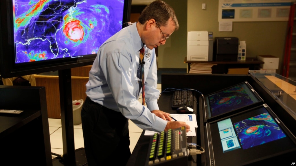
Chief hurricane forecaster James Franklin prepares for a live update on Hurricane Earl at the National Hurricane Center in Miami.​

During his time at NOAA, Franklin was on research teams that made breakthroughs in tropical storm forecasting and in the understanding of the winds circling a hurricane's eye. His research with dropsondes — sensor-filled tubes that send weather data as they fall through hurricanes — helped improve forecasts of storm tracks and led NOAA to buy a "hurricane hunter" jet that's still used today. He also helped develop new GPS dropsondes that showed how eyewall winds vary. Before his June 30 retirement, ending a 35-year NOAA career that included 83 flights breaching hurricane eyewalls, Franklin discussed forecasting with The Associated Press:

Uneven forecast improvements

Hurricane track forecasts have steadily improved partly because the weather elements that direct a storm's path are easy to see, Franklin said. For example, a high-pressure area over the Atlantic known as the Bermuda High, which can nudge storms toward land instead of over open waters, is hundreds of miles (kilometers) across. However, forecasting intensity has been more difficult because it depends on the interactions between the ocean and thunderstorms at the core of a tropical storm, and those interactions happen in an area just tens of miles (kilometers) wide and are difficult to observe even with advanced dropsondes, drones and satellites, Franklin said. "We've always been able to see many or most of the steering factors or steering features in the atmosphere, and we get better at it all the time,'' he said.

18833427-16EF-48DF-BA4D-77A621F52E3D_cx0_cy7_cw0_w1023_r1_s.jpg

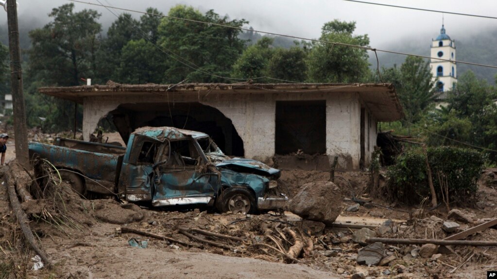
A pickup lies destroyed next to a house damaged by a mudslide in Xaltepec, on the mountainous north of Puebla state, Mexico, Aug. 7, 2016. The death toll from the remnants of Hurricane Earl grew to more than 30 in Mexico as a new tropical storm formed off the country's Pacific Coast.​

"But when it comes to intensity, what's going to make a tropical depression strengthen into a hurricane — now you're talking about all kinds of things going on in the atmosphere on very small scales. You're talking about the interface between the ocean and the atmosphere. How much heat is going to get extracted from that ocean? That's a big driver for intensification.''

Despite forecasts, use caution

Improved forecasts, however, can be a double-edged sword, Franklin said. Despite a variety of warnings and advisories highlighting specific storm hazards, such as storm surge flooding, some people still expect hurricanes to stick to a predicted track, even though forecasts include a range of potential outcomes. "I find this surprising because there's still so many bad forecasts out there — ours included — yet we see it over and over: people don't have a good grasp on just what the forecast uncertainties still are,'' he said.

Potential storm advisories

See also:

Red Cross: Social Ills Make Disasters Worse in Latin America, Caribbean
June 02, 2017 — High levels of violence and inequality complicate the challenge of managing humanitarian risks in Latin America and the Caribbean, a region that is not investing enough in keeping its people safe, said a top Red Cross official.
As the Caribbean hurricane season approaches, Walter Cotte, Americas director for the International Federation of Red Cross and Red Crescent Societies (IFRC), said the region was making use of early warning systems and was better positioned to deal with the wrath of huge storms, but still needed to spend more on preparing for natural disasters. “We are advancing enough in response, the problem is we’re not advancing enough in prevention,” Cotte said on the sidelines of a recent U.N. disasters conference in Cancun. “This is a gap, and we’re condemned to pay for response instead of investing in prevention.”

Many issues, but violence is No. 1

He listed tackling violence as the top priority in a region where gangs rule the streets of many towns and cities, and murder rates have been on the rise. Latin America also needs to combat high rates of road accidents, hydro-meteorological problems like water shortages, and unhealthy lifestyles, whose effects such as obesity are proving expensive to tackle in the world’s most unequal region.

7D39040B-BC48-4963-8687-D5B1DDEA83C9_w650_r0_s.jpg

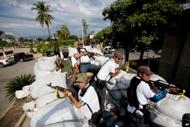
Men belonging to the Self-Defense Council of Michoacan ride on a sandbag-filled truck while trying to flush out alleged members of The Caballeros Templarios drug cartel from the town of Nueva Italia, Mexico​

Honduras, which is struggling to contain drug-fueled gang violence and organized crime, is one country where the Red Cross is helping thousands of people who are fleeing, and is even working with gangs such as the Mara Salvatrucha (MS-13) to try to reduce violence, Cotte said. “We are focused on resilience, and this long-term approach is really creating a new way to offer solutions to communities,” he said.

Caribbean making progress

While low-lying Caribbean islands, among the most exposed to rising sea levels and other climate change impacts, are making progress in adapting, more resources are needed to improve technology and coordinate fragmented disaster response, Cotte said.

37CDFF28-F818-4003-890B-14E33B88539B_w650_r0_s.jpg

A worker nails a board to a storefront window as protection against Hurricane Matthew in Kingston, Jamaica​

Comparing the impact of last year’s Hurricane Matthew on Haiti where up to 1,000 were killed while mass evacuations in Cuba avoided deaths, Cotte said greater cooperation between governments, business and aid agencies in the region was key. “Now the hurricane season is stronger and more frequent. ... The impacts are very big, and if you’re not yet at the level of preparation required, (it) will be worse for your population,” he said.

Red Cross: Social Ills Make Disasters Worse in Latin America, Caribbean
 
The National Weather Service has issued a warning for yet
another catastrophic hurricane following on the heels of
Ivan and Jeanne. The path of this hurricane zigs and zags,
and is therefore highly unpredictable. Experts predict that
this one will cause the most damage to the United States
that we have experienced in four years.


They are naming this one Hurricane Kerry.

Be advised, the only way for citizens to protect themselves

is by hiding behind a Bush.

Will it wipe out Jersey?

Far out man

-Geaux
 
Huh, a year before THE global warming knocked out New Orleans.

Then over a decade since the US has been hit by a cat 3 or stronger.

I owe Gore an apology. It was right around that time when he was selling carbon credits in bulk. It looks like it worked.

I mean if all of those hurricanes were all due THE global warming, then what is the explanation for the lack of hurricanes since?

Thank you Gore!
 
Budget Cuts Could Hurt Hurricane Predictions...
eek.gif

Forecaster: Budget Cuts Could Hurt Hurricane Predictions
July 03, 2017 — Recent progress in forecasting the intensity of hurricanes — which has lagged behind storm track forecasting — could be undermined by proposed cuts in federal funding for tropical weather research, says the retiring chief of a team of U.S. hurricane specialists.
The National Oceanic and Atmospheric Administration launched the Hurricane Forecast Improvement Program in 2009 with a $13 million budget. Funding has shrunk to less than half that, and President Donald Trump's proposed budget includes further cuts to NOAA and the National Weather Service. "It's hanging on really by a thread in terms of funding," said James Franklin, who oversees the National Hurricane Center team that releases tropical storm forecasts and warnings.

2A192070-E5C1-4130-9652-D174284D1624_cx0_cy10_cw0_w1023_r1_s.jpg

Chief hurricane forecaster James Franklin prepares for a live update on Hurricane Earl at the National Hurricane Center in Miami.​

During his time at NOAA, Franklin was on research teams that made breakthroughs in tropical storm forecasting and in the understanding of the winds circling a hurricane's eye. His research with dropsondes — sensor-filled tubes that send weather data as they fall through hurricanes — helped improve forecasts of storm tracks and led NOAA to buy a "hurricane hunter" jet that's still used today. He also helped develop new GPS dropsondes that showed how eyewall winds vary. Before his June 30 retirement, ending a 35-year NOAA career that included 83 flights breaching hurricane eyewalls, Franklin discussed forecasting with The Associated Press:

Uneven forecast improvements

Hurricane track forecasts have steadily improved partly because the weather elements that direct a storm's path are easy to see, Franklin said. For example, a high-pressure area over the Atlantic known as the Bermuda High, which can nudge storms toward land instead of over open waters, is hundreds of miles (kilometers) across. However, forecasting intensity has been more difficult because it depends on the interactions between the ocean and thunderstorms at the core of a tropical storm, and those interactions happen in an area just tens of miles (kilometers) wide and are difficult to observe even with advanced dropsondes, drones and satellites, Franklin said. "We've always been able to see many or most of the steering factors or steering features in the atmosphere, and we get better at it all the time,'' he said.

18833427-16EF-48DF-BA4D-77A621F52E3D_cx0_cy7_cw0_w1023_r1_s.jpg

A pickup lies destroyed next to a house damaged by a mudslide in Xaltepec, on the mountainous north of Puebla state, Mexico, Aug. 7, 2016. The death toll from the remnants of Hurricane Earl grew to more than 30 in Mexico as a new tropical storm formed off the country's Pacific Coast.​

"But when it comes to intensity, what's going to make a tropical depression strengthen into a hurricane — now you're talking about all kinds of things going on in the atmosphere on very small scales. You're talking about the interface between the ocean and the atmosphere. How much heat is going to get extracted from that ocean? That's a big driver for intensification.''

Despite forecasts, use caution

Improved forecasts, however, can be a double-edged sword, Franklin said. Despite a variety of warnings and advisories highlighting specific storm hazards, such as storm surge flooding, some people still expect hurricanes to stick to a predicted track, even though forecasts include a range of potential outcomes. "I find this surprising because there's still so many bad forecasts out there — ours included — yet we see it over and over: people don't have a good grasp on just what the forecast uncertainties still are,'' he said.

Potential storm advisories

See also:

Red Cross: Social Ills Make Disasters Worse in Latin America, Caribbean
June 02, 2017 — High levels of violence and inequality complicate the challenge of managing humanitarian risks in Latin America and the Caribbean, a region that is not investing enough in keeping its people safe, said a top Red Cross official.
As the Caribbean hurricane season approaches, Walter Cotte, Americas director for the International Federation of Red Cross and Red Crescent Societies (IFRC), said the region was making use of early warning systems and was better positioned to deal with the wrath of huge storms, but still needed to spend more on preparing for natural disasters. “We are advancing enough in response, the problem is we’re not advancing enough in prevention,” Cotte said on the sidelines of a recent U.N. disasters conference in Cancun. “This is a gap, and we’re condemned to pay for response instead of investing in prevention.”

Many issues, but violence is No. 1

He listed tackling violence as the top priority in a region where gangs rule the streets of many towns and cities, and murder rates have been on the rise. Latin America also needs to combat high rates of road accidents, hydro-meteorological problems like water shortages, and unhealthy lifestyles, whose effects such as obesity are proving expensive to tackle in the world’s most unequal region.

7D39040B-BC48-4963-8687-D5B1DDEA83C9_w650_r0_s.jpg

Men belonging to the Self-Defense Council of Michoacan ride on a sandbag-filled truck while trying to flush out alleged members of The Caballeros Templarios drug cartel from the town of Nueva Italia, Mexico​

Honduras, which is struggling to contain drug-fueled gang violence and organized crime, is one country where the Red Cross is helping thousands of people who are fleeing, and is even working with gangs such as the Mara Salvatrucha (MS-13) to try to reduce violence, Cotte said. “We are focused on resilience, and this long-term approach is really creating a new way to offer solutions to communities,” he said.

Caribbean making progress

While low-lying Caribbean islands, among the most exposed to rising sea levels and other climate change impacts, are making progress in adapting, more resources are needed to improve technology and coordinate fragmented disaster response, Cotte said.

37CDFF28-F818-4003-890B-14E33B88539B_w650_r0_s.jpg

A worker nails a board to a storefront window as protection against Hurricane Matthew in Kingston, Jamaica​

Comparing the impact of last year’s Hurricane Matthew on Haiti where up to 1,000 were killed while mass evacuations in Cuba avoided deaths, Cotte said greater cooperation between governments, business and aid agencies in the region was key. “Now the hurricane season is stronger and more frequent. ... The impacts are very big, and if you’re not yet at the level of preparation required, (it) will be worse for your population,” he said.

Red Cross: Social Ills Make Disasters Worse in Latin America, Caribbean
waltky do you not know how to start a new thread ???
 
Huh, a year before THE global warming knocked out New Orleans.

Then over a decade since the US has been hit by a cat 3 or stronger.

I owe Gore an apology. It was right around that time when he was selling carbon credits in bulk. It looks like it worked.

I mean if all of those hurricanes were all due THE global warming, then what is the explanation for the lack of hurricanes since?

Thank you Gore!
Do you realize that there is a whole world out there beyond our borders?

Meanwhile, the northern hemisphere just had its most intense tropical storm season ever
It’s surprising, but true. While the U.S. has been experiencing a hurricane drought, at least in terms of hurricanes making landfall, the northern hemisphere just had the most active tropical storm season in recorded history.

Here are just a few of the records set by last year’s tropical storms.

Tropical storm records set in 2015:
  • Most major storms: Last year, the world saw 30 major storms (category 3 or higher), far above the previous record of 23, set in 2004.
  • Most powerful storm: Hurricane Patricia, which formed off the coast of Mexico last October, had sustained wind speeds that peaked at 215 mph, faster than any tropical storm ever recorded.
  • 2 major storms in the Arabian Sea: The Arabian Sea, where tropical storms are uncommon due to its dry and windy climate, had 2 major cyclones last year. Before last year, only 6 major cyclones had ever been recorded in the Arabian Sea.
  • Easternmost hurricane: In September of last year, Hurricane Fred struck Cabo Verde, traveling further east in the Atlantic than any previous hurricane.
  • Latest hurricane: Though technically part of the 2016 season, hurricane Alex became only the second ever documented January hurricane. Alex attained hurricane status on 1/14/2016, 10 days later than the previous January hurricane, which became a hurricane on 1/4/1938.
  • Every Recorded Hurricane, Cyclone, and Typhoon Since 1850 - Metrocosm
 
waltky do you not know how to start a new thread ???

Granny says dat's why dey's a search feature...

... to look up threads already started onna topic.
 
Huh, a year before THE global warming knocked out New Orleans.

Then over a decade since the US has been hit by a cat 3 or stronger.

I owe Gore an apology. It was right around that time when he was selling carbon credits in bulk. It looks like it worked.

I mean if all of those hurricanes were all due THE global warming, then what is the explanation for the lack of hurricanes since?

Thank you Gore!
Do you realize that there is a whole world out there beyond our borders?

Meanwhile, the northern hemisphere just had its most intense tropical storm season ever
It’s surprising, but true. While the U.S. has been experiencing a hurricane drought, at least in terms of hurricanes making landfall, the northern hemisphere just had the most active tropical storm season in recorded history.

Here are just a few of the records set by last year’s tropical storms.

Tropical storm records set in 2015:
  • Most major storms: Last year, the world saw 30 major storms (category 3 or higher), far above the previous record of 23, set in 2004.
  • Most powerful storm: Hurricane Patricia, which formed off the coast of Mexico last October, had sustained wind speeds that peaked at 215 mph, faster than any tropical storm ever recorded.
  • 2 major storms in the Arabian Sea: The Arabian Sea, where tropical storms are uncommon due to its dry and windy climate, had 2 major cyclones last year. Before last year, only 6 major cyclones had ever been recorded in the Arabian Sea.
  • Easternmost hurricane: In September of last year, Hurricane Fred struck Cabo Verde, traveling further east in the Atlantic than any previous hurricane.
  • Latest hurricane: Though technically part of the 2016 season, hurricane Alex became only the second ever documented January hurricane. Alex attained hurricane status on 1/14/2016, 10 days later than the previous January hurricane, which became a hurricane on 1/4/1938.
  • Every Recorded Hurricane, Cyclone, and Typhoon Since 1850 - Metrocosm
Oh, the carbon credits did not work?

Boooo Gore!
 

Forum List

Back
Top