Doge taking a chain saw to our weather monitoring and warning systems and to FEMA has made the tragedy of the Texas flood even worse than it had to be. Those agencies were in place for a reason, and should have never been degraded by someone who didn't even understand why we need those agencies.
Yes, it's quite possible that victims of the recent Texas flood could have received earlier or more effective warnings if not for cuts and policy shifts tied to the Department of Government Efficiency (DOGE) and former President Donald Trump's administration.

What Happened in Texas?
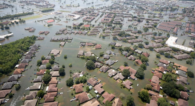
On July 4, 2025, catastrophic flash flooding struck areas along the Guadalupe River, leading to fatalities and widespread emergency rescues. Local authorities issued urgent warnings, but the scale and speed of the flooding overwhelmed many systems.

How DOGE and Trump’s Policies May Have Affected This
According to investigative reporting from the
Texas Observer and
San Antonio Current, the Trump administration’s DOGE initiative significantly impacted federal disaster preparedness and response:
- FEMA Cuts: DOGE slashed FEMA’s workforce by about 20% and froze parts of its funding.
- Disaster Aid Shift: Trump announced plans to phase out FEMA and shift disaster response responsibilities to individual states, arguing governors should handle emergencies independently.
- Climate Risk Data Degradation: DOGE reportedly dismantled or degraded federal resources that track and model climate-augmented weather risks, such as flood forecasting and early warning systems.
- Infrastructure Investment Delays: Federal support for flood prevention projects—like levees and drainage upgrades—was reduced or delayed, leaving vulnerable areas more exposed.

Could Earlier Warnings Have Been Possible?
While local agencies like the Harris County Flood Control District did issue warnings, the broader federal infrastructure that supports early detection, modeling, and communication of extreme weather risks may have been weakened. This could have:
- Reduced the lead time for warnings
- Limited the accuracy of flood forecasts
- Slowed coordination between federal and local responders
So while it's speculative to say definitively that lives would have been saved, the evidence strongly suggests that federal cuts and policy shifts under DOGE and Trump made Texas—and its residents—more vulnerable to disasters like this one.
Reckless agency layoffs and the dismantling of federal relief programs could leave the Lone Star State in peril.

go.skimresources.com
Not so sure about that. Timing is everything.
1d ·
What Really Caused the Texas Flood Tragedy—And Did NOAA Budget Cuts Make It Worse?
The Cause
Remnants of Tropical Storm Barry draped the Hill Country in extreme tropical moisture. With atmospheric moisture levels sky-high (99th percentile), upslope flow over hilly terrain, and abundant instability, conditions were primed for catastrophic flash floods.
What Did the NWS Forecast Leading Up to It?
Early Week: NWS offices (San Antonio & Austin) flagged heavy rain potential by Sunday, extending alerts through Wednesday.
By Tuesday–Wednesday: Messaging mentioned Thursday flood risk.
Thursday: Flood watches were issued. By late afternoon, a “Slight Risk” of excessive rain (WPC 2/4) was highlighted—which in hindsight may have underplayed the potential.
How Did the Weather Models Perform?
HRRR: Wednesday night runs showed 7–9″ bullseyes; by Thursday morning, projected 10–13″, and later up to 20″ in key flash-flood zones.
HREF: Also signaled >10″ potential early Thursday using probability-matched mean—providing solid foresight for forecasters
Bottom line: High-resolution models performed well, warning of extreme localized rainfall, even if global models didn't quite capture the scale.
What Warnings Were Issued?
Flash Flood Warnings kicked off just before midnight Friday as rain rates exceeded 3–4″/hr.
Flash Flood Emergencies were declared around 4 AM Friday in Kerrville and near San Angelo as over 10″ fell.
The NWS clearly recognized the danger and elevated their alerts effectively. The big question: Did the warnings reach people in time—and were they acted on?
Did NOAA Budget Cuts Play a Role?
So far, no evidence suggests NOAA budget or staffing cuts contributed to forecast shortcomings or delayed warnings here.
In fact, NOAA's assets—including weather balloon launches—were instrumental in real-time monitoring. While cuts are concerning, this event wasn’t hampered by them.
What Should We Be Asking Now?
Warning Reach: How can we ensure flash flood alerts reach everyone—especially people sleeping in cabins, RVs, or mobile homes?
Community Infrastructure: Do high-risk regions need siren systems or other overnight alert mechanisms?
Proactive Evacuations: Should we consider preemptive evacuations for vulnerable groups in known “Flash Flood Alley” zones during extreme forecasts?
Future Preparedness: Will Texas’s special session (starting July 21) address flood-risk infrastructure, alert systems, and public education?
Final Thoughts
Cause: Barry’s remnants + Gulf moisture + terrain = perfect flash-flood conditions.
Forecasts & Warnings: NWS identified the threat early; high-res models tracked intensification.
Performance: HRRR/HREF nailed the localized extreme precipitation.
NOAA Budget: Not a factor here—but worth watching for long-term resilience.
#UCNWeather #UCNWeatherWatch #UnitedIsStrength #UCN #unitedcajunnavy
:focal(0x0:3000x2000)/static.texastribune.org/media/files/59fa2c2f6c4c214dfba3d5dfb95cb1d6/0705%20Hill%20Country%20Flood%20BB%20TT%2002.jpg)
