1srelluc
Diamond Member
They did but given the time of night many folk's phones were off. I don't know if localities did a landline alert or not given how quick things went downhill.
Follow along with the video below to see how to install our site as a web app on your home screen.
Note: This feature may not be available in some browsers.
They did but given the time of night many folk's phones were off. I don't know if localities did a landline alert or not given how quick things went downhill.
"Maxdeath" sounds like someone promoting maximum death. The avatar as well. Not really "sensitive." That's all I meant.Maxdeath isn't wrong on this though as far as the weather forecasting. I hate Trump. I hate MAGA. I hate the GOP. I really want to find a way to assign culpability to them for this. I cannot, however, find any evidence of it. Extra staff was on hand in Texas, the warnings went out. It was just really sucky timing being in the middle of the night when a lot of people weren't up to get updated more severe forecast than the one that had been out during the day/evening. Sort of the same thing happened here in 2018 with Tropical Storm Michael except the radical last minute change in the forecast from breezy and showers to Batten Down The Hatches went out in the afternoon when people were already out shopping and working and such. That storm was supposed to hit a cold front out in the sticks many hours later far from here. Instead, that cold front started moving in faster and they collided right over our city, unleashing an unholy amount of rain.
ok thx Relluc , they indeed did do their job as they normally would have , the timing of which just didn't work out ?They did but given the time of night many folk's phones were off.
Remember, we had to close the mental institutions years ago. Now they have cellphones.“The Weather Service’s nearby San Antonio office, which covers other areas hit by the floods, also had significant vacancies, including a warning coordination meteorologist and science officer, Mr. Fahy said. Staff members in those positions are meant to work with local emergency managers to plan for floods, including when and how to warn local residents and help them evacuate.
That office’s warning coordination meteorologist left on April 30, after taking the early retirement package the Trump administration used to reduce the number of federal employees, according to a person with knowledge of his departure.
[…]
Under the Trump administration, the Weather Service, like other federal agencies, has been pushed to reduce its number of employees. By this spring, through layoffs and retirements, the Weather Service had lost nearly 600 people from a work force that until recently was as large as 4,000.”
Less government, more death and destruction.
But at least their taxes are lower than they would otherwise be.
Trump is starting to look as a contributor to the death of these children as a result of his DOGE cuts.Doge taking a chain saw to our weather monitoring and warning systems and to FEMA has made the tragedy of the Texas flood even worse than it had to be. Those agencies were in place for a reason, and should have never been degraded by someone who didn't even understand why we need those agencies.
Yes, it's quite possible that victims of the recent Texas flood could have received earlier or more effective warnings if not for cuts and policy shifts tied to the Department of Government Efficiency (DOGE) and former President Donald Trump's administration.
What Happened in Texas?
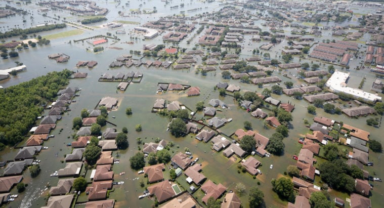
On July 4, 2025, catastrophic flash flooding struck areas along the Guadalupe River, leading to fatalities and widespread emergency rescues. Local authorities issued urgent warnings, but the scale and speed of the flooding overwhelmed many systems.
How DOGE and Trump’s Policies May Have Affected This
According to investigative reporting from the Texas Observer and San Antonio Current, the Trump administration’s DOGE initiative significantly impacted federal disaster preparedness and response:
- FEMA Cuts: DOGE slashed FEMA’s workforce by about 20% and froze parts of its funding.
- Disaster Aid Shift: Trump announced plans to phase out FEMA and shift disaster response responsibilities to individual states, arguing governors should handle emergencies independently.
- Climate Risk Data Degradation: DOGE reportedly dismantled or degraded federal resources that track and model climate-augmented weather risks, such as flood forecasting and early warning systems.
- Infrastructure Investment Delays: Federal support for flood prevention projects—like levees and drainage upgrades—was reduced or delayed, leaving vulnerable areas more exposed.
Could Earlier Warnings Have Been Possible?
While local agencies like the Harris County Flood Control District did issue warnings, the broader federal infrastructure that supports early detection, modeling, and communication of extreme weather risks may have been weakened. This could have:
- Reduced the lead time for warnings
- Limited the accuracy of flood forecasts
- Slowed coordination between federal and local responders
So while it's speculative to say definitively that lives would have been saved, the evidence strongly suggests that federal cuts and policy shifts under DOGE and Trump made Texas—and its residents—more vulnerable to disasters like this one.
Trump’s DOGE Cuts Are a Texas-Sized Disaster
Reckless agency layoffs and the dismantling of federal relief programs could leave the Lone Star State in peril.go.skimresources.com
NWS hiring early June.....for the hurricane season. 125 positions, meteorologists and specialists.These people were not replaced
Prove me wrong
warning was issued at 1 am ... the flooding occurred at around 5 am ... I'm wondering if and when a watch was posted ... there were adults with those pre-teen girls ... they should have been prepared ...this is what MAGAs believe is WINNINGDoge taking a chain saw to our weather monitoring and warning systems and to FEMA has made the tragedy of the Texas flood even worse than it had to be. Those agencies were in place for a reason, and should have never been degraded by someone who didn't even understand why we need those agencies.
Yes, it's quite possible that victims of the recent Texas flood could have received earlier or more effective warnings if not for cuts and policy shifts tied to the Department of Government Efficiency (DOGE) and former President Donald Trump's administration.
On July 4, 2025, catastrophic flash flooding struck areas along the Guadalupe River, leading to fatalities and widespread emergency rescues. Local authorities issued urgent warnings, but the scale and speed of the flooding overwhelmed many systems.
According to investigative reporting from the Texas Observer and San Antonio Current, the Trump administration’s DOGE initiative significantly impacted federal disaster preparedness and response:
- FEMA Cuts: DOGE slashed FEMA’s workforce by about 20% and froze parts of its funding.
- Disaster Aid Shift: Trump announced plans to phase out FEMA and shift disaster response responsibilities to individual states, arguing governors should handle emergencies independently.
- Climate Risk Data Degradation: DOGE reportedly dismantled or degraded federal resources that track and model climate-augmented weather risks, such as flood forecasting and early warning systems.
- Infrastructure Investment Delays: Federal support for flood prevention projects—like levees and drainage upgrades—was reduced or delayed, leaving vulnerable areas more exposed.
While local agencies like the Harris County Flood Control District did issue warnings, the broader federal infrastructure that supports early detection, modeling, and communication of extreme weather risks may have been weakened. This could have:
- Reduced the lead time for warnings
- Limited the accuracy of flood forecasts
- Slowed coordination between federal and local responders
So while it's speculative to say definitively that lives would have been saved, the evidence strongly suggests that federal cuts and policy shifts under DOGE and Trump made Texas—and its residents—more vulnerable to disasters like this one.
Trump’s DOGE Cuts Are a Texas-Sized Disaster
Reckless agency layoffs and the dismantling of federal relief programs could leave the Lone Star State in peril.
Two groups, one around 200, the other around 300 took buyouts and retirements.....out of 560.This idiot wants me to back up actual interviews with people affected by the reduction. Dude, just go ask Trump what happened. You’ve been lying this whole thread. Acting like cutting hundreds of jobs is semantics.
Dude they eliminated 600 jobs. Now they are scrambling to hire 125 immediately because of the negative effect of the random headcount reduction. They can’t staff many locations and said that if they didnt hire more people they would have to expand the offices that can’t function. Good thing weather disasters happen 9-5 M-F and not after hours or on weekends/holidays.Two groups, one around 200, the other around 300 took buyouts and retirements.....out of 560.
Only need 125 new hires.
You aren't entitled to your own facts.
Thanks for posting this ...
Thiswarningwas issued at 1 am ... the flooding occurred at around 5 am ... I'm wondering if and when awatchwas posted ... there were adults with those pre-teen girls ... they should have been prepared ...
200 specially trained weather forecasters at work.Dude they eliminated 600 jobs. Now they are scrambling to hire 125 immediately because of the negative effect of the random headcount reduction. They can’t staff many locations and said that if they didnt hire more people they would have to expand the offices that can’t function. Good thing weather disasters happen 9-5 M-F and not after hours or on weekends/holidays.
You are acting like 600 jobs didnt disappear. They did. You can’t deny that. 200 were specifically for weather forecasting.

You are acting like they were fired, they weren't........You are acting like 600 jobs didnt disappear
When a person retires another person takes their job… or that is a headcount reduction with less people getting things done. There were 600 people working who disappeared and all their work was moved onto other people.You are acting like they were fired, they weren't........
Voluntary separation.
watch means flooding could happen, a warning means flooding is happening ... emergency means "run for high ground RIGHT NOW" ...
Stop with the bullshit.The jobs that are gone that caused this disaster wont be replaced.