Millions on East Coast could be in Danger!

I am in Florida and everyone is freaking out over a storm up north and i just gotta laugh at them. No one makes this big of a deal when hurricanes are heading towards us or when ones are heading to Texas or NO's SMH.
This isn't just a hurricane, it is going to be a superstorm, if everything falls together as it is anticipated to do. And they are not exactly used to hurricanes in that part of th country to begin with. The potential for flooding, snow falls, etc. are falling into the once in 250 year range. This is not just any ordinary storm, if things come together as the models are predicting. We here in Florida know what to do, what to expect. Those up north haven't dealt with this type situation in many decades, possibly centuries.
 
I am in Florida and everyone is freaking out over a storm up north and i just gotta laugh at them. No one makes this big of a deal when hurricanes are heading towards us or when ones are heading to Texas or NO's SMH.
This isn't just a hurricane, it is going to be a superstorm, if everything falls together as it is anticipated to do. And they are not exactly used to hurricanes in that part of th country to begin with. The potential for flooding, snow falls, etc. are falling into the once in 250 year range. This is not just any ordinary storm, if things come together as the models are predicting. We here in Florida know what to do, what to expect. Those up north haven't dealt with this type situation in many decades, possibly centuries.

Suppose you have a point.
 
I am in Florida and everyone is freaking out over a storm up north and i just gotta laugh at them. No one makes this big of a deal when hurricanes are heading towards us or when ones are heading to Texas or NO's SMH.
This isn't just a hurricane, it is going to be a superstorm, if everything falls together as it is anticipated to do. And they are not exactly used to hurricanes in that part of th country to begin with. The potential for flooding, snow falls, etc. are falling into the once in 250 year range. This is not just any ordinary storm, if things come together as the models are predicting. We here in Florida know what to do, what to expect. Those up north haven't dealt with this type situation in many decades, possibly centuries.
well i just hope it not as bad as forecast. People lives as we have seen before can be destoryed by these things.
 
I am in Florida and everyone is freaking out over a storm up north and i just gotta laugh at them. No one makes this big of a deal when hurricanes are heading towards us or when ones are heading to Texas or NO's SMH.
This isn't just a hurricane, it is going to be a superstorm, if everything falls together as it is anticipated to do. And they are not exactly used to hurricanes in that part of th country to begin with. The potential for flooding, snow falls, etc. are falling into the once in 250 year range. This is not just any ordinary storm, if things come together as the models are predicting. We here in Florida know what to do, what to expect. Those up north haven't dealt with this type situation in many decades, possibly centuries.

Suppose you have a point.
the key is the goverment, local authoirty, all govenors and police need to ensure they do everything possible to protect these states.

Next few days could be horrible.
 
Malloy Warns Residents: Prepare For Worst Flooding In 70 years And Widespread,Long-Lasting Power Outages

Published: Sunday, October 28, 2012
By The Associated Press

HARTFORD — Gov. Dannel P. Malloy did not mince words during a press conference Sunday night on the impact of Hurricane Sandy.

“This is the largest threat to human life this state has experienced in anyone’s lifetime,” he said. “This is not a joke. This is a real warning of possible death by drowning.”

Malloy expressed concern over the duration of the storm and the resulting high tides. He said residents should expect the storm to last 36 hours, and impact four high tide cycles. The worst of those high tides, expected to be Monday evening, could be a storm surge as high as 11 feet, Malloy said, leading to “unprecedented flooding.”

Winds are expected to be sustained at 40 to 60 miles-per-hour, with gusts as high as 80 miles-per-hour.


“The last time we saw anything like this was never,” he said.

...

Malloy even took the rare step of a conference call with representatives from all but two towns on Connecticut’s shore, to transmit the urgency of the situation.

“We did something extraordinary today,” he said. “We did it because I did not believe people were taking it seriously.”

Earlier Sunday, Malloy said that coastal areas in the state are expected to see the worst flooding in 70 years and that power outages will be widespread and last a long time.
Malloy warns residents: Prepare for worst flooding in 70 years and widespread, long-lasting power outages (interactive map)- The New Haven Register - Serving New Haven, Connecticut
 
Meanwhile, Fairfield has ordered a mandatory evacuation of the beach area beginning at noon Sunday, according to First Selectman Michael Tetreau. An emergency shelter will open at Ludlowe High School at noon Sunday for people and pets. "We need to complete evacuations before nightfall when wind and rain begin to strengthen. Be prepared to stay away from the area for several days," Tetreau said.


Read more: Fairfield orders shoreline evacuation - Connecticut Post
 
Crews of utility workers arrives at Glen Burnie facility in Md. as Hurricane Sandy approach in the Atlantic coast on Sunday, Oct. 28, 2012. Baltimore Gas and Electric company BGE is completing the set up and logistics for operations sites for crews prior to the arrival of the superstorm. Photo: Jose Luis Magana / AP
628x471.jpg

628x471.jpg

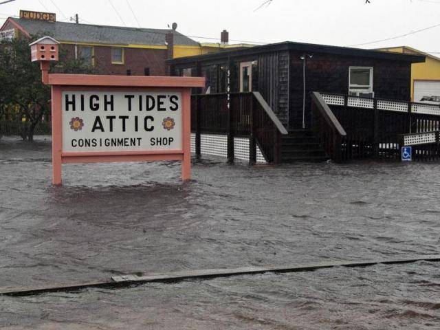
Ocean water rolls over NC 12 at the north end of Buxton, N.C. at dawn on Sunday, Oct. 28, 2012. Waves from offshore Hurricane Sandy are battering Hatteras Island. Photo: The Virginian-Pilot, Steve Earley / AP
Sandy wreaks havoc on coast - Connecticut Post
 
Last edited:
Crews of utility workers arrives at Glen Burnie facility in Md. as Hurricane Sandy approach in the Atlantic coast on Sunday, Oct. 28, 2012. Baltimore Gas and Electric company BGE is completing the set up and logistics for operations sites for crews prior to the arrival of the superstorm. Photo: Jose Luis Magana / AP
628x471.jpg

628x471.jpg

Ocean water rolls over NC 12 at the north end of Buxton, N.C. at dawn on Sunday, Oct. 28, 2012. Waves from offshore Hurricane Sandy are battering Hatteras Island. Photo: The Virginian-Pilot, Steve Earley / AP
Sandy wreaks havoc on coast - Connecticut Post

2nd pic looked like snow.
 
Tip - don't forget to get prescriptions filled if you will be needing them soon before this fully hits tomorrow.
 
I remember when Republicans wanted to cut "disaster relief". They said the US shouldn't be a "nanny state". Eric Cantor was leading the charge, until his district was hit by an earthquake and then a hurricane. God, these Republicans. So awful.

you are just a hateful SOB..EVERYTHING is politics and hate of others for you
Cantor's the hateful one.

rdean is just the messenger.

Why haven't we heard from Gov. Christie Kreme?

Christie was on a lot yesterday, both tv a radio.
 
If you have a portable radio, both 98.7 FM and Deportes 1050 will be providing a simulcast of Eyewitness News during our continuous coverage of Sandy.

"The time for preparing and talking is about over," Federal Emergency Management Administrator Craig Fugate warned as Hurricane Sandy made its way up the Atlantic on a collision course with two other weather systems that could turn it into one of the most fearsome storms on record in the U.S. "People need to be acting now."
New York area braces for Hurricane Sandy | 7online.com

since the article I believe over 6000 flights have now been cancelled.
 
A6VmPkFCMAAXik1.jpg

Monmouth Beach Earlier #HurricaneSandy #Sandy #SandyABC7 #MonmouthBeach #NJ pic.twitter.com/qWNFUmcV
A6VgMRyCcAA9p45.jpg

Pt. Pleasant Inlet around 7pm #HurricaneSandy #Sandy #SandyABC7 #PtPleasant #Inlet #NJ pic.twitter.com/tJf7M5z5
 

Forum List

Back
Top