Navigation
Install the app
How to install the app on iOS
Follow along with the video below to see how to install our site as a web app on your home screen.

Note: This feature currently requires accessing the site using the built-in Safari browser.
More options
You are using an out of date browser. It may not display this or other websites correctly.
You should upgrade or use an alternative browser.
You should upgrade or use an alternative browser.
Anyone interested in routes, maps, borders and boundaries etc?
- Thread starter Mindful
- Start date

- Aug 10, 2009
- 168,037
- 16,519
- 2,165
- Banned
- #2
google driving distances from x to y
OldLady
Diamond Member
- Nov 16, 2015
- 69,568
- 19,600
- 2,220
I love maps. What area are you looking for?Can't find a thread on this stuff.
leftwinger
Diamond Member
Anywhere and everywhere.
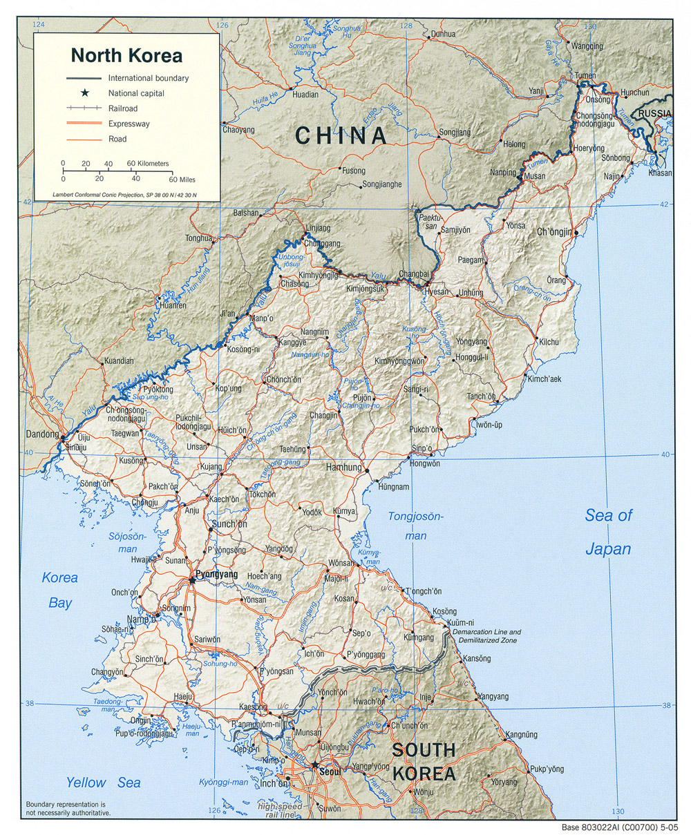
Latest to spark my interest was an account of the Russian North Korean border.
Here is a map for you. Maybe more dangerous than NK? Weird shape too. Sucks up a lot of Tax dollars to keep them "isolated and protected". Nice, freeway bypass all around. Their potholes get fixed. Need a new road? No problem there.
Edit: Google maps. A great site. You can do street view and see your old living areas.
Last edited:
I bought a beautiful, new world atlas a couple of years ago and it is already obsolete. Every few years new nations appear out of ancient conflicts still seething.
As Wiki shows, even defining what a "nation" is gets complicated.
The UN defines 206 listed "states".
Of these 193 participate in the UN. The other 13 do not.
Palestine is disputed by Israel, and vice versa.
Vatican is treated as an "observer" not as a full member of the UN.
Abkhazi is claimed by Georgia.
Kosovo is claimed by Serbia.
Artsakh is claimed by Azerbaijan.
Cyprus has split unofficially.
Sahrawi is claimed by Morocco.
Somaliland is claimed by Somalia.
South Ossetia was liberated by Russia but still claimed by Georgia.
PRC claims Taiwan still.
Transnistria is claimed by Moldova.
Wiki is always a good start since it is updated most currently, but it is not really considered a solid resource since it is not a primary source.
But it is quick and dirty.
List of sovereign states - Wikipedia
I also have a road atlas booklet for my State as well as each of the surrounding Rocky Mountain states, mostly for hunting trips, but also for backpacking trips without hunting as well. I have friends in nearby states who are not hunters but we like to go backpacking together.
These state road atlases also show all jeep trails and USFS (National Forests) lands as well as BLM (Bureau Of Land Management). This is where hunting is allowed in the USA.
These state road atlases also show all jeep trails and USFS (National Forests) lands as well as BLM (Bureau Of Land Management). This is where hunting is allowed in the USA.
spam.Anywhere and everywhere.
Latest to spark my interest was an account of the Russian North Korean border.
Here is a map for you. Maybe more dangerous than NK? Weird shape too. Sucks up a lot of Tax dollars to keep them "isolated and protected". Nice, freeway bypass all around. Their potholes get fixed. Need a new road? No problem there.
View attachment 122945
if I catch anyone spamming too much they (singular possessive form) go onto the infamous iggy list.
OldLady
Diamond Member
- Nov 16, 2015
- 69,568
- 19,600
- 2,220
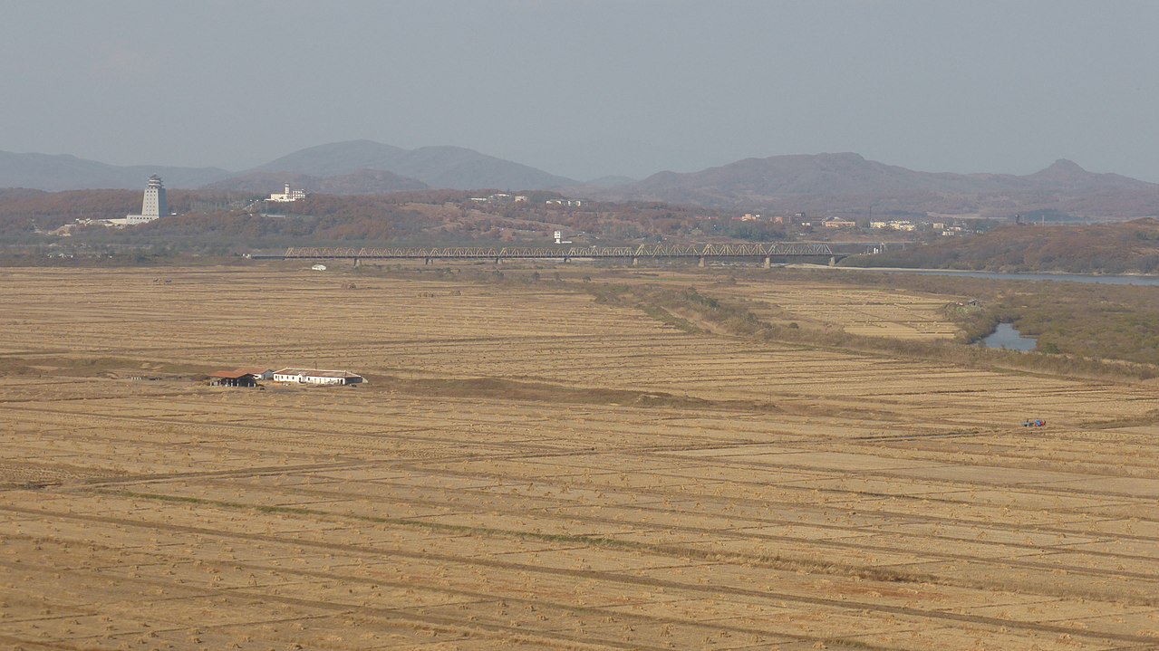
The Friendship Bridge linking North Korea and Russia. Korea is in the foreground and Khasan is on the right. The tower on the left is in Chinese territory.
It looks like river delta bottom land, doesn't it? A lot of flooding in the Spring, I'll bet.
OldLady
Diamond Member
- Nov 16, 2015
- 69,568
- 19,600
- 2,220
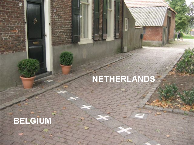
What do the people living in that flat do? Shower in Belgium and eat dinner in Netherlands?This one's interesting.
Before I go buck deer hunting I always google-earth the trails I plan to hike to see where the deer might be hiding.
They normally hide in the daytimes and come out at sunset and feed then, and again at midnight, and again at 4 a.m., and again just before sunrise.
They sometimes frolic before going back to bed (bedding down) just after dawn.
They normally hide in the daytimes and come out at sunset and feed then, and again at midnight, and again at 4 a.m., and again just before sunrise.
They sometimes frolic before going back to bed (bedding down) just after dawn.
All I know about this area of the world is that the Rooskies have a big naval base nearby.
The Friendship Bridge linking North Korea and Russia. Korea is in the foreground and Khasan is on the right. The tower on the left is in Chinese territory.
It looks like river delta bottom land, doesn't it? A lot of flooding in the Spring, I'll bet.
It's where they keep half of their submarine fleet -- both the boomers and the A-boats.
Mindful
Diamond Member
- Thread starter
- Banned
- #20
What do the people living in that flat do? Shower in Belgium and eat dinner in Netherlands?This one's interesting.
Something like that.
The border doesn’t follow kerblines, as you’d expect in an urban setting. It runs through homes, shops and offices. It hits a building and emerges at an angle the other side of it. You can sit at a cafe table and your companion will be in another country. The result is a patchwork quilt of Dutch and Belgian islands. Check it out here.
Similar threads
- Replies
- 8
- Views
- 101
- Replies
- 69
- Views
- 772
- Replies
- 3
- Views
- 96
- Replies
- 2
- Views
- 199
- Replies
- 0
- Views
- 110
Latest Discussions
- Replies
- 791
- Views
- 4K
- Replies
- 69
- Views
- 570
Forum List
-
-
-
-
-
Political Satire 8059
-
-
-
-
-
-
-
-
-
-
-
-
-
-
-
-
-
-
-
ObamaCare 781
-
-
-
-
-
-
-
-
-
-
-
Member Usernotes 469
-
-
-
-
-
-
-
-
-
-