But that difference is greater than 15 degrees. So test isn't valid for your hypothesis, fail.You don't think air temperatures 10-15 degrees warmer than normal might have some effect on melt rates?
If you think the melt rate changes, then test it.
Okay. I froze a whole tray of ice overnight. I took half the cubes and placed them in my sink. I left the other half in the freezer. The ones in the sink melted much faster than the ones in the freezer.
Science.
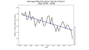
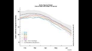
Scaling.