Really? Doesn't look like that to me.
That's because you have your head jammed so incredibly far up your ass, SSooooDDuuumb.
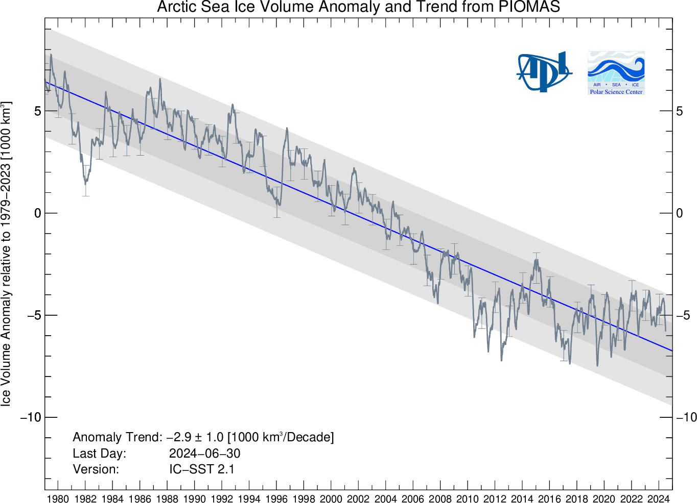
The thread topic was Arctic sea ice and that's what we were talking about. As you knew.
Conflating the shrinking Arctic sea ice, which is in a death spiral, with the maximum extent of the much less significant Antarctic sea ice, which shrinks to almost nothing at its minimum every year, is just the usual fossil fuel industry/denier cult deceptive propaganda gimmick.
Arctic sea ice has been rapidly disappearing, shrinking in both extent and volume for decades, but especially fast over the last decade or so where it has declined in extent from 2.31 million square miles in 2002 to only 1.32 million square miles in 2012. This ice loss radically changes the Earth's albedo as highly reflective sea ice vanishes and is replaced by the strongly light-absorbing dark sea water. This is a global warming positive feedback loop where warming causes sea ice loss which increases ocean warming, causing further ice loss, resulting in more warming and then more ice loss, and so on and so on. Most climate scientists think that the Arctic sea ice is in a downward death spiral. The disappearance of this ice is already affecting weather patterns all over the northern latitudes. This Arctic ice loss is ongoing, almost continuous, and very radical.
In contrast, almost all of the ice around the southern pole is resting on the continent of Antarctica. Ice sheets two miles thick and enormous glaciers are now melting and losing ice mass and raising sea levels. Surrounding the continent of Antarctica is a fringe of seasonal sea ice that melts away almost completely very summer and reforms in the winter. For this reason, global sea ice extents are almost meaningless for understanding what is happening to the Earth's ice. Which is why you denier cultists try to cite them so often in your attempt to confuse people with the meaningless numbers you get when you add up the Southern Hemisphere winter maximum ice extents and ignore the enormously smaller SH summer minimum extents.

These images using satellite-derived sea ice concentration data show average minimum and maximum sea ice during March and September for the Arctic and Antarctic from 1979 to 2000. Seasons are opposite between the Southern and Northern Hemispheres; the South reaches its summer minimum in February, while the North reaches its summer minimum in September. (March is shown for both hemispheres for consistency.) The black circles in the center of the Northern Hemisphere images are areas lacking data due to limitations in satellite coverage at the North Pole.
Almost all of the sea ice that forms during the Antarctic winter melts during the summer. During the winter, up to 18 million square kilometers (6.9 million square miles) of ocean is covered by sea ice, but by the end of summer, only about 3 million square kilometers (1.1 million square miles) of sea ice remain.
(source: National Snow and Ice Data Center, University of Colorado, Boulder, Colorado.)