What is a BOMB CYCLONE? And why are they so dangerous?

Billy_Bob

Diamond Member
Sep 4, 2014
30,837
20,604
1,945
Top Of The Great Divide
A "Bomb Cyclone" Is nothing more than a very organized low-pressure storm system. Much like a hurricane, these form over the land and the cold of the upper atmosphere, and two jet streams meeting and flowing together remove competing waves in the atmosphere allowing the low pressure to intensify. This low pressure will drop in barometric pressure at the core. IF a low pressure drops 1 millibar in pressure, each hour, for 24 hours, it then becomes a sustained drop in pressures and the organization of the low strengthens. The very cold air aloft is pushed to the earth's surface very rapidly, just as it does in the eye wall of a hurricane. This is the criteria for a low-pressure center to be called a "Bomb Cyclone".

The low pressure over Wyoming dropped temperatures 42 degrees F. in less than 30 minutes. This shattered the all-time one hour drop record by 5 degrees F and did it in 30 min. (the old record was 37 deg F in 37 min). We went from 38 degrees F to -29 degrees F after just 75 minutes. That is a 67 degree drop in temperature. Inside 12 hours and 30 minutes we reached the low of -42 degrees F. And these are ambient temperatures, not wind-chill temps.

In total, we dropped 81 degrees F inside 12 hours 30 minutes. The record for total drop in temperature is 100 degrees F that was recorded in Yellowstone's Ranger Station in 1933.

THE DANGER: These organized storms can freeze you to death in short order if you are not properly dressed and able to take cover. Here is the wind chill calculator for the point where we reached -29 and had sustained winds of 35 mph.

1671859414376.png


The 'feels like' temp is -67.3 deg F. The important value to know is how much energy is being stripped from exposed skin. 2,671 W/m^2. (Watts per meter ^2) This means that a person with just 1-meter square of skin exposed will lose 2,671 watts of energy. It takes just 2,500 watts loss of energy to freeze exposed skin in 60 seconds.

Storms like this, which catch people unprepared, can kill.

These storms were very frequent in the 1930's and 1960's during the cooling phases of the solar cycles. We have just begun to experience them again as we return to the cooling phase of our solar cycles. They will become more and more frequent the longer we continue to cool.

This is what these storms are capable of. When I was a child, I remember having to crawl out the kitchen window and shovel out the door of the house. Later that day my brothers and I were jumping off the roof of the house into snow drifts. I didn't know it at the time, but we had made history as one of the worst snow falls in modern history.

I lived in northeastern Montana at the time. The picture below was of North Dakota in 1966. Some regions had 27 feet of snow after that series of storms was done.
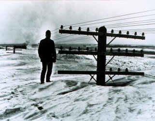
northdakota 1966.jpg

Can you imagine the chaos today if this occurred once again? We are again in the flow pattern that caused this storm. We are again having these very large and very low-pressure storms. They were called blizzards back then..
 
Last edited:
'Low pressure storm system' just doesn't create enough fear as a 'BOMB CYCLONE'


Same weather, just different name
Well, they had to make it sound bad. Weve been dealing with these systems for a very long time. Changing the name makes it possible to drive fear. If CAGW were real and the hot spot over the equatorial regions existed, the planetary waves would not allow these to occur. Just one more piece of evidence that dispels the CAGW myth.
 
Just wait... There is a blocking high just off the east coast. This thing could stall over the mid-west. We had just two days under this thing. Can you imagine what it will do over DC and that region if it stalls for 7-10 days?
 
A "Bomb Cyclone" Is nothing more than a very organized low-pressure storm system. Much like a hurricane, these form over the land and the cold of the upper atmosphere, and two jet streams meeting and flowing together remove competing waves in the atmosphere allowing the low pressure to intensify. This low pressure will drop in barometric pressure at the core. IF a low pressure drops 1 millibar in pressure, each hour, for 24 hours, it then becomes a sustained drop in pressures and the organization of the low strengthens. The very cold air aloft is pushed to the earth's surface very rapidly, just as it does in the eye wall of a hurricane. This is the criteria for a low-pressure center to be called a "Bomb Cyclone".

The low pressure over Wyoming dropped temperatures 42 degrees F. in less than 30 minutes. This shattered the all-time one hour drop record by 5 degrees F and did it in 30 min. (the old record was 37 deg F in 37 min). We went from 38 degrees F to -29 degrees F after just 75 minutes. That is a 67 degree drop in temperature. Inside 12 hours and 30 minutes we reached the low of -42 degrees F. And these are ambient temperatures, not wind-chill temps.

In total, we dropped 81 degrees F inside 12 hours 30 minutes. The record for total drop in temperature is 100 degrees F that was recorded in Yellowstone's Ranger Station in 1933.

THE DANGER: These organized storms can freeze you to death in short order if you are not properly dressed and able to take cover. Here is the wind chill calculator for the point where we reached -29 and had sustained winds of 35 mph.

View attachment 741611

The 'feels like' temp is -67.3 deg F. The important value to know is how much energy is being stripped from exposed skin. 2,671 W/m^2. (Watts per meter ^2) This means that a person with just 1-meter square of skin exposed will lose 2,671 watts of energy. It takes just 2,500 watts loss of energy to freeze exposed skin in 60 seconds.

Storms like this, which catch people unprepared, can kill.

These storms were very frequent in the 1930's and 1960's during the cooling phases of the solar cycles. We have just begun to experience them again as we return to the cooling phase of our solar cycles. They will become more and more frequent the longer we continue to cool.

This is what these storms are capable of. When I was a child, I remember having to crawl out the kitchen window and shovel out the door of the house. Later that day my brothers and I were jumping off the roof of the house into snow drifts. I didn't know it at the time, but we had made history as one of the worst snow falls in modern history.

I lived in northeastern Montana at the time. The picture below was of North Dakota in 1966. Some regions had 27 feet of snow after that series of storms was done.

View attachment 741614

Can you imagine the chaos today if this occurred once again? We are again in the flow pattern that caused this storm. We are again having these very large and very low-pressure storms. They were called blizzards back then..
That pic reminds me of the blizzard of 1978 back when I was a kid. We had no food, no utilities and were burning furniture and the framing of non-load bearing walls. It's why I vowed to be prepared for this kind of shitstorm. I'm one of those "prepper" guys.

Me and my brother were going to check on an elderly neighbor and he tripped over a power line. At first I thought the power line was down, but then I saw the top of a utility pole and realized that the power line wasn't down, we were trudging through the snow of a 16 foot high snowdrift.
 
Last edited:
A "Bomb Cyclone" Is nothing more than a very organized low-pressure storm system. Much like a hurricane, these form over the land and the cold of the upper atmosphere, and two jet streams meeting and flowing together remove competing waves in the atmosphere allowing the low pressure to intensify. This low pressure will drop in barometric pressure at the core. IF a low pressure drops 1 millibar in pressure, each hour, for 24 hours, it then becomes a sustained drop in pressures and the organization of the low strengthens. The very cold air aloft is pushed to the earth's surface very rapidly, just as it does in the eye wall of a hurricane.

I took these images around midday on Friday which might help illustrate what you are talking about! This first image was of the organization of the jet streams over the USA:

Screen Shot 2022-12-23 at 3.35.16 AM.jpg


These other maps show the temperature distribution at various levels of the atmosphere--- this first one was the temperature distribution at the surface:

Screen Shot 2022-12-23 at 5.05.14 PM.png


This was at about mid-level:

Screen Shot 2022-12-23 at 5.07.04 PM.png


Finally, this last one was high up in the troposphere:

Screen Shot 2022-12-23 at 5.08.24 PM.png


Maybe it is better to look at them in the reverse order, that way, you can see the progression from the cold, upper air mass stored aloft next to the descent of the cold air toward the surface as warmer air is brought in from off the Atlantic in exchange replacing the lost upper air via an opposing jet stream, illustrating much of what you were talking about.


This is the criteria for a low-pressure center to be called a "Bomb Cyclone".
Yeah, bomb cyclone--- a term which has half the frightened housewives in the country running for cover under their beds! :sleep: Maybe a more apt name might have been a Low Pressure Bomb.

When I was a child, I remember having to crawl out the kitchen window and shovel out the door of the house. Later that day my brothers and I were jumping off the roof of the house into snow drifts. I didn't know it at the time, but we had made history as one of the worst snow falls in modern history.
Yes, but weren't winters a lot more fun for us kids in those days?! I remember us digging tunnels into big snow drifts and carving out little "club-rooms" for us to crawl into and sit and talk-- -- -- it was actually surprisingly warm nestled inside those snow "clubhouses!" You could really build up quite a collection of winter-time objects, like snowmen and snowballs and the challenge was to see who could make the biggest as we rolled these balls around making them as big as possible trying to lift them into place. Then, the sadness of seeing them slowly melt away in the Spring. ☃️
 
Last edited:
Just wait... There is a blocking high just off the east coast. This thing could stall over the mid-west. We had just two days under this thing. Can you imagine what it will do over DC and that region if it stalls for 7-10 days?

It won't. It's going to move off the east coast and in a few more days will be seeing temps in the 50's by end of next week.
 
I took these images around midday on Friday which might help illustrate what you are talking about! This first image was of the organization of the jet streams over the USA:

View attachment 741623

These other maps show the temperature distribution at various levels of the atmosphere--- this first one was the temperature distribution at the surface:

View attachment 741624

This was at about mid-level:

View attachment 741625

Finally, this last one was high up in the troposphere:

View attachment 741626

Maybe it is better to look at them in the reverse order, that way, you can see the progression from the cold, upper air mass stored aloft next to the descent of the cold air toward the surface as warmer air is brought in from off the Atlantic in exchange replacing the lost upper air via an opposing jet stream, illustrating much of what you were talking about.


Yeah, bomb cyclone--- a term which has half the frightened houdsewives in the country running for cover under their beds! :sleep: Maybe a more apt name might have been a Low Pressure Bomb.


Yes, but weren't winters a lot more fun for us kids in those days?! I remember us digging tunnels into big snow drifts and carving out little "club-rooms" for us to crawl into and sit and talk-- -- -- it was actually surprisingly warm nestled inside those snow "clubhouses!" You could really build up quite a collection of winter-time objects, like snowmen and snowballs and the challenge was to see who could make the biggest as we rolled these balls around making them as big as possible trying to life them into place. Then, the sadness of seeing them slowly melt away in the Spring. ☃️
There was no competing wind shear. This is what happens when both the polar jet and the Equitorial jet merge as one. There was nothing to slow the storms formation. Thanks for the screen shots.
 

Forum List

Back
Top