ScienceRocks
Democrat all the way!
- Thread starter
- Banned
- #141

Follow along with the video below to see how to install our site as a web app on your home screen.

Note: This feature currently requires accessing the site using the built-in Safari browser.
look at the cold fronts on this map for today, you can see there is no sign of any el nino
Thanks NOAA

BTW I'm waiting to see wind patterns from the west coast. Since it is wind that starts the cycles.

Boy, silly ol' Boob, that looks like some pretty strong dying. And, tell me, just why does an El Nada have to die? Maybe because your silly ass predictions were pulled out of your ass, just like this one. I think that I will go with the predictions from the hundreds of scientists at NOAA and NASA, rather than a proven liar on an internet board.
This weeks numbers are +1.09 deg C anomaly.. a drop from +1.21deg C Anomaly the previous week. The cold is dissipating the warm pool. NO kelvin wave has formed.
Just not seeing any increase but certainly seeing the cool down. SOI is -1.8 indicating the lack of any oscillations.. This thing is doing as predicted... dying..
By early May 2015, weak to moderate El Niño conditions were reflected by above-average sea surface temperatures (SST) across the equatorial Pacific (Fig. 1), and by the corroborating tropical atmospheric response. The latest weekly Niño indices were +1.2°C in the Niño-4 region, +1.0°C in the Niño-3.4 region, and +1.2°C and +2.3°C in the Niño-3 and Niño-1+2 regions, respectively (Fig. 2). Subsurface temperature anomalies remained substantially above average (Fig. 3), partly in response to a downwelling oceanic Kelvin wave, which resulted in strong positive subsurface anomalies across the central and eastern Pacific (Fig. 4). This anomalous warmth has subsequently persisted in association with El Niño-related ocean-atmosphere coupling. This coupling includes enhanced convection over the central equatorial Pacific (Fig. 5), along with persistent low-level westerly wind anomalies over the western and central equatorial Pacific and persistent upper-level easterly wind anomalies over the central Pacific. Also, the equatorial Southern Oscillation Index (EQSOI) remained negative during the month. Collectively, these features reflect weak to moderate strength El Niño conditions.

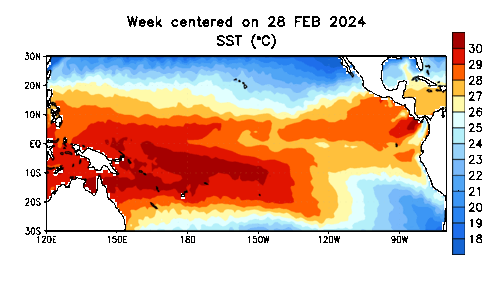
IN this world view you can see that the Indian Ocean is harboring most of the heat. The cross over into the Indian ocean through the Archipelago renders the heated water dead. Without oscillations to push it back across the pacific there is no significant El Nino..
It's all predictions a lot is with guesses too bad for you and CaliforniaEvery data set now shows that we have a nino...It is just a fact of life. We will likely end up with one as strong as 2010.
It is a typical short term climate shift that is normal, but for the poor sobs that get the extreme weather they probably wish it didn't happen.
Both the atmospheric and oceanic setup supports that we have a nino. I'll stick with decades of reality.
Ready for what? With what and how? Dude you make me laugh cause you think you have some super hero climate guy power.Too funnySo chicken little the meteorologist what do you propose we do?
And you propose we not study it and be ready for it? That seems to be your solution for everything. The weird thing about that is we wouldn't be a first world power if we followed those directions.

By God, that is a better cartoon than the ones Wildcard presents. And funnier, also.
So tooth, is el nino part of the Atlantic? Dah......As expected, the forecast is for a below-normal Atlantic hurricane season, since El Nino conditions tend to make wind shear that breaks up hurricane formation.
NOAA Below-normal Atlantic Hurricane Season is likely this year.
I don't know, it's close, but I did like the other cartoon by Wildcard quite a lot. But of course everything you do is better right?By God, that is a better cartoon than the ones Wildcard presents. And funnier, also.