LOL how is a CAT-3 storm the most destructive storm EVER.......

You think wrong, since they were not.


And you're grossly uneducated about your topic. What devastated New Orleans was not the hurricane. It was the collapse of the levees underbuilt by the US Army Corps of Engineers.

I'm never wrong.

If my street has bad pothole, I get the city to take care of it. And, until it's fixed I steer around it. I suppose I might even be motivated to do something about it myself, if the city is slack (e.g. fill it with sand, simple and cheap, until a proper repair).

The feds might have the job of maintaining levees, but it's the city's job get the feds to come, to prohibit building in low land, and to even apply cheap and simple fixes until the feds do their job. But, New Orleans is a city that had been ran by incompetent apes for a long time. Blacks elected by racism not qualifications.

You're grossly stupid.


No actually I'm a Katrinite who actually lived there when Katrina arrived and therefore know whereof I speak and therefore don't need to pull it out of my ass. Like you just did.


lol......ok......whatever you say s0n!!:eusa_dance::eusa_dance:

Next he'll be posting up about how he's part of the Cajun Navy!!:popcorn:
 
The inhabitants of Pompei also laughed at Vesuvius for decades as it rumbled.
There is no way you can know that. Your "claim" is the very reason the global warming bullshit fails. You made it all up, just like the Pompeii claim.
 
Irma was supposed to hit Florida as a CAT 4 and not slow down to CAT 3 until near the top of Florida; instead, it hit Florida Keys already as a CAT 3 (where the Keys really DID take a good beating), and so did Naples, but right after Naples, it went inland, slowed to CAT 2 and totally missed Tampa. Shortly after it dispersed to CAT 1.

Bullshit. It hit Key West as a Cat 4. Where it was "supposed to" go changed daily. One poster here said it was following Harvey into Texas. Then it turned up this way. Then it pointed toward New Orleans. Finally it settled on west Florida. That's how these things work --- nobody can predict them a week out. Can't be done.


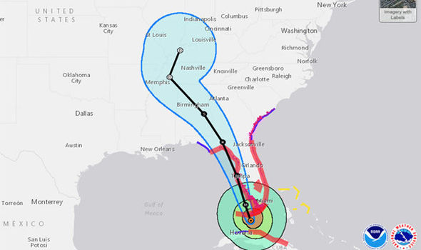
After hitting Naples, the storm tracked across the peninsula eastward diagonally up to where Florida, Georgia and the Atlantic meet. From there it went sightly out to sea then straight up into the Carolinas. It continues to track due north. It has NEVER veered sharply westward inland towards Tennessee and Kentucky, as they thought.

Yeah that's more bullshit. I'm sitting here IN Carolina --- the western part --- and I can tell you right now there ain't no Irma here. We know our winds around here and there haven't been any.

And the map knows too:

023911_5day_cone_no_line_and_wind.png


Think you can find "Tennessee and Kentucky" on that map?


God you are an idiot...........and I rarely use that term in here...............

:spinner:http://www.msn.com/en-us/news/other/dollar150-billion-misfire-how-forecasters-got-irma-damage-wrong/ar-AArKOqd:spinner:


Fucking snowflakes.......they get hysterical about anything.( we need an exploding head emoticon )

Pogo is carrying the forecast in his pocket, or so he says.

He keeps it with his schitzo meds
 
Irma was supposed to hit Florida as a CAT 4 and not slow down to CAT 3 until near the top of Florida; instead, it hit Florida Keys already as a CAT 3 (where the Keys really DID take a good beating), and so did Naples, but right after Naples, it went inland, slowed to CAT 2 and totally missed Tampa. Shortly after it dispersed to CAT 1.

Bullshit. It hit Key West as a Cat 4. Where it was "supposed to" go changed daily. One poster here said it was following Harvey into Texas. Then it turned up this way. Then it pointed toward New Orleans. Finally it settled on west Florida. That's how these things work --- nobody can predict them a week out. Can't be done.


After hitting Naples, the storm tracked across the peninsula eastward diagonally up to where Florida, Georgia and the Atlantic meet. From there it went sightly out to sea then straight up into the Carolinas. It continues to track due north. It has NEVER veered sharply westward inland towards Tennessee and Kentucky, as they thought.

Yeah that's more bullshit. I'm sitting here IN Carolina --- the western part --- and I can tell you right now there ain't no Irma here. We know our winds around here and there haven't been any.

And the map knows too:

023911_5day_cone_no_line_and_wind.png


Think you can find "Tennessee and Kentucky" on that map?


God you are an idiot...........and I rarely use that term in here...............

:spinner:http://www.msn.com/en-us/news/other/dollar150-billion-misfire-how-forecasters-got-irma-damage-wrong/ar-AArKOqd:spinner:


Fucking snowflakes.......they get hysterical about anything.( we need an exploding head emoticon )


One more time for the Illiterati...........
"From there it went sightly out to sea then straight up into the Carolinas. It continues to track due north. It has NEVER veered sharply westward inland towards Tennessee and Kentucky, as they thought."

--- that look like "due north" on the map there, shitforbrains? Hm?

Once again Stupid --- I'm **IN** the Carolinas. There is no Irma here. She went way to the west. You might say, "sharply westward inland toward Tennessee and Kentucky". As they thought. As that map CLEARLY shows.

Fucking retard.
 
The Weather Gods are Angry: Unleash the Ginormous Climate Change Hurricanes!!!!

oops.

 
Irma was supposed to hit Florida as a CAT 4 and not slow down to CAT 3 until near the top of Florida; instead, it hit Florida Keys already as a CAT 3 (where the Keys really DID take a good beating), and so did Naples, but right after Naples, it went inland, slowed to CAT 2 and totally missed Tampa. Shortly after it dispersed to CAT 1.

Bullshit. It hit Key West as a Cat 4. Where it was "supposed to" go changed daily. One poster here said it was following Harvey into Texas. Then it turned up this way. Then it pointed toward New Orleans. Finally it settled on west Florida. That's how these things work --- nobody can predict them a week out. Can't be done.


After hitting Naples, the storm tracked across the peninsula eastward diagonally up to where Florida, Georgia and the Atlantic meet. From there it went sightly out to sea then straight up into the Carolinas. It continues to track due north. It has NEVER veered sharply westward inland towards Tennessee and Kentucky, as they thought.

Yeah that's more bullshit. I'm sitting here IN Carolina --- the western part --- and I can tell you right now there ain't no Irma here. We know our winds around here and there haven't been any.

And the map knows too:

023911_5day_cone_no_line_and_wind.png


Think you can find "Tennessee and Kentucky" on that map?


God you are an idiot...........and I rarely use that term in here...............

:spinner:http://www.msn.com/en-us/news/other/dollar150-billion-misfire-how-forecasters-got-irma-damage-wrong/ar-AArKOqd:spinner:


Fucking snowflakes.......they get hysterical about anything.( we need an exploding head emoticon )


One more time for the Illiterati...........
"From there it went sightly out to sea then straight up into the Carolinas. It continues to track due north. It has NEVER veered sharply westward inland towards Tennessee and Kentucky, as they thought."
--- that look like "due north" on the map there, shitforbrains? Hm?

Once again Stupid --- I'm **IN** the Carolinas. There is no Irma here. She went way to the west. You might say, "sharply westward inland toward Tennessee and Kentucky". As they thought. As that map CLEARLY shows.

Fucking retard.

Pogo you are seriously retarded, the storm tracked DUE NORTH after turning when it headed for Florida from Cuba.

So again take your pills please

BULLSHIT. SEE THE FUCKING MAP, STUPID.

I have seen the map, the storm turned due North when exiting Cuba for the keys. How stupid are you? The storm left Cuba traveling North then veered to the East then went up your ass and to your brain.

Kid you really need help
 
Sandy knocked out both power and cell towers here for weeks.
Actually what did the most damage was the Nor'Easter that followed Superstorm Sandy.

Some "superstorm" it made landfall with wind speeds of less than 90 miles per hour..

It is all fake news all the time with you guys isn't it...and fake history whenever you think you can get away with it.
 
Irma was supposed to hit Florida as a CAT 4 and not slow down to CAT 3 until near the top of Florida; instead, it hit Florida Keys already as a CAT 3 (where the Keys really DID take a good beating), and so did Naples, but right after Naples, it went inland, slowed to CAT 2 and totally missed Tampa. Shortly after it dispersed to CAT 1.

Bullshit. It hit Key West as a Cat 4. Where it was "supposed to" go changed daily. One poster here said it was following Harvey into Texas. Then it turned up this way. Then it pointed toward New Orleans. Finally it settled on west Florida. That's how these things work --- nobody can predict them a week out. Can't be done.


After hitting Naples, the storm tracked across the peninsula eastward diagonally up to where Florida, Georgia and the Atlantic meet. From there it went sightly out to sea then straight up into the Carolinas. It continues to track due north. It has NEVER veered sharply westward inland towards Tennessee and Kentucky, as they thought.

Yeah that's more bullshit. I'm sitting here IN Carolina --- the western part --- and I can tell you right now there ain't no Irma here. We know our winds around here and there haven't been any.

And the map knows too:

023911_5day_cone_no_line_and_wind.png


Think you can find "Tennessee and Kentucky" on that map?


God you are an idiot...........and I rarely use that term in here...............

:spinner:http://www.msn.com/en-us/news/other/dollar150-billion-misfire-how-forecasters-got-irma-damage-wrong/ar-AArKOqd:spinner:


Fucking snowflakes.......they get hysterical about anything.( we need an exploding head emoticon )


One more time for the Illiterati...........
"From there it went sightly out to sea then straight up into the Carolinas. It continues to track due north. It has NEVER veered sharply westward inland towards Tennessee and Kentucky, as they thought."
--- that look like "due north" on the map there, shitforbrains? Hm?

Once again Stupid --- I'm **IN** the Carolinas. There is no Irma here. She went way to the west. You might say, "sharply westward inland toward Tennessee and Kentucky". As they thought. As that map CLEARLY shows.

Fucking retard.

Pogo you are seriously retarded, the storm tracked DUE NORTH after turning when it headed for Florida from Cuba.

So again take your pills please

BULLSHIT. SEE THE FUCKING MAP, STUPID.
FYI-
if you look at the radar maps, irma went north west, but the storm was so large, its bands went over charleston and caused storm surge and major flooding....is what they showed on the news...
 
Who told you that Irma missed Tampa? I live in the bay area and the eye (literally) went right over my house. Hell the storm literally emptied out much of the bay. It takes a 20 second Google search to see that the storm hit Tampa, I mean seriously that's just laziness.

Nice try.

It's always nice to hear someone talk out of their ass while accusing others of laziness.

A). The eye did NOT go right over your house! When people refer to the "storm," they mean the eye where the winds were most severe. At the very best, if you lived on the extreme inland part of the Bay, then the extreme outer edge of what used to be the center of the storm barely brushed your area. It was supposed to hit you dead on as a CAT 4 or 3. You got off with a song. By the time the storm got up to the Tampa area, there wasn't even an eye any longer! What was left of it was tracking up the center of the peninsula at that point as only a CAT 1 system by then with no eye. It was supposed to be a CAT 3 or 4. But don't take my word, you can view the animation of the longwave satellite imagery right here in the geostationary satellite image browser:

Data and Imagery -- SSEC

B). That the storm emptied out your Bay is irrelevant. That doesn't mean the storm "hit" your area. The storm in total area was the size of Texas and covered the whole state and was affecting water levels hundreds of miles away. It probably affected water levels along Corpus Christi. You probably saw winds of 85 mph, but was supposed to see winds over 150 mph! Just be glad it pulled water out of the Bay; in the original NOAA forecast, they had it flooding your area by 10 feet deep over land.

If you want to see people who got /hit/ by the storm, go visit the Keys, the coast of Cuba, or better yet, those couple of Caribbean islands where whole houses were blown away under 185 mph winds with nothing left to show they were ever even there.
 
Bullshit. It hit Key West as a Cat 4. Where it was "supposed to" go changed daily. One poster here said it was following Harvey into Texas. Then it turned up this way. Then it pointed toward New Orleans. Finally it settled on west Florida. That's how these things work --- nobody can predict them a week out. Can't be done.


Yeah that's more bullshit. I'm sitting here IN Carolina --- the western part --- and I can tell you right now there ain't no Irma here. We know our winds around here and there haven't been any.

And the map knows too:

023911_5day_cone_no_line_and_wind.png


Think you can find "Tennessee and Kentucky" on that map?


God you are an idiot...........and I rarely use that term in here...............

:spinner:http://www.msn.com/en-us/news/other/dollar150-billion-misfire-how-forecasters-got-irma-damage-wrong/ar-AArKOqd:spinner:


Fucking snowflakes.......they get hysterical about anything.( we need an exploding head emoticon )


One more time for the Illiterati...........
"From there it went sightly out to sea then straight up into the Carolinas. It continues to track due north. It has NEVER veered sharply westward inland towards Tennessee and Kentucky, as they thought."
--- that look like "due north" on the map there, shitforbrains? Hm?

Once again Stupid --- I'm **IN** the Carolinas. There is no Irma here. She went way to the west. You might say, "sharply westward inland toward Tennessee and Kentucky". As they thought. As that map CLEARLY shows.

Fucking retard.

Pogo you are seriously retarded, the storm tracked DUE NORTH after turning when it headed for Florida from Cuba.

So again take your pills please

BULLSHIT. SEE THE FUCKING MAP, STUPID.

I have seen the map, the storm turned due North when exiting Cuba for the keys. How stupid are you? The storm left Cuba traveling North then veered to the East then went up your ass and to your brain.

Kid you really need help

--- and when it got to the Florida panhandle it turned LEFT and went NORTHWEST --- which is exactly what the previous poster denied it did. And, he claims, the storm came here.

Well it didn't. The map proves it, and I can fucking see it out my window. That was bullshit last night and it's still bullshit now and on May 16th of the year 2472 it will STILL be bullshit.

The NWS map above updates every time the page refreshes but here's a composite. Check out where the Carolinas are (Greensboro, Greenville, Charlotte, Raleigh) --- where he claimed the storm came -- and where Nashville is, where he claims it didn't.

hurricane-irma-852253.jpg


Here in fact is a capture of the NWS map as it appeared September 9, when it was still on the north coast of Cuba, before landfall in Key West. Note the projected path going right to Tennessee and Kentucky, not the Carolinas. Note that not only DID it INDEED follow that path, it actually veered even further west of it.

huricane-irma.jpg

But then you're still a fucking liar so at least you're consistent.
 
Last edited:
Irma was supposed to hit Florida as a CAT 4 and not slow down to CAT 3 until near the top of Florida; instead, it hit Florida Keys already as a CAT 3 (where the Keys really DID take a good beating), and so did Naples, but right after Naples, it went inland, slowed to CAT 2 and totally missed Tampa. Shortly after it dispersed to CAT 1.

Bullshit. It hit Key West as a Cat 4. Where it was "supposed to" go changed daily. One poster here said it was following Harvey into Texas. Then it turned up this way. Then it pointed toward New Orleans. Finally it settled on west Florida. That's how these things work --- nobody can predict them a week out. Can't be done.


After hitting Naples, the storm tracked across the peninsula eastward diagonally up to where Florida, Georgia and the Atlantic meet. From there it went sightly out to sea then straight up into the Carolinas. It continues to track due north. It has NEVER veered sharply westward inland towards Tennessee and Kentucky, as they thought.

Yeah that's more bullshit. I'm sitting here IN Carolina --- the western part --- and I can tell you right now there ain't no Irma here. We know our winds around here and there haven't been any.

And the map knows too:

023911_5day_cone_no_line_and_wind.png


Think you can find "Tennessee and Kentucky" on that map?


God you are an idiot...........and I rarely use that term in here...............

:spinner:http://www.msn.com/en-us/news/other/dollar150-billion-misfire-how-forecasters-got-irma-damage-wrong/ar-AArKOqd:spinner:

Fucking snowflakes.......they get hysterical about anything.( we need an exploding head emoticon )

I commend you on your restraint of the use of the word 'idiot.'

The storm had briefly returned to CAT 4 leaving Cuba then collapse back to CAT 3 as it went over the west Keys onto Florida proper, starved of fuel by the massive dry air mass over Florida that NOAA had somehow missed, dropping down to CAT 2 and 1 by the time it got half way up the state.

Such storms are pretty static hydrodynamic systems with fairly fixed inflow factors. Things on the scale of a hurricane simply do not change much over the course of a few days. Where the problems lie is in the computer models needing further refinement. I was predicting the storm would go further west a couple days before when it was still over the Dominican Republic while NOAA was still calling for Miami as its target.

What HAD been Irma, now nothing more than a disassociated tropical depression, DID go up the Carolina coast briefly as it went inland, not west Carolina wherever that is, as a bit of wind and rain; you can still watch the longwave satellite animation here in the geostationary satellite image browser:

Data and Imagery -- SSEC

The actual path the center of the storm took was HERE (my drawing):

023911_5day_cone_no_line_and_wind.png


The storm NEVER went anywhere near the path towards Nashville and S. Illinois as their European model forecast. By the time it entered S. Carolina, it was already breaking up from a CAT 1 with no further rotation and spreading out as some cloud and a little rain in an east-west direction.

As to Pogo, I'm very glad you know your winds. Now if only you knew your facts.
 
Last edited:
Bullshit. It hit Key West as a Cat 4. Where it was "supposed to" go changed daily. One poster here said it was following Harvey into Texas. Then it turned up this way. Then it pointed toward New Orleans. Finally it settled on west Florida. That's how these things work --- nobody can predict them a week out. Can't be done.


Yeah that's more bullshit. I'm sitting here IN Carolina --- the western part --- and I can tell you right now there ain't no Irma here. We know our winds around here and there haven't been any.

And the map knows too:

023911_5day_cone_no_line_and_wind.png


Think you can find "Tennessee and Kentucky" on that map?


God you are an idiot...........and I rarely use that term in here...............

:spinner:http://www.msn.com/en-us/news/other/dollar150-billion-misfire-how-forecasters-got-irma-damage-wrong/ar-AArKOqd:spinner:


Fucking snowflakes.......they get hysterical about anything.( we need an exploding head emoticon )


One more time for the Illiterati...........
"From there it went sightly out to sea then straight up into the Carolinas. It continues to track due north. It has NEVER veered sharply westward inland towards Tennessee and Kentucky, as they thought."
--- that look like "due north" on the map there, shitforbrains? Hm?

Once again Stupid --- I'm **IN** the Carolinas. There is no Irma here. She went way to the west. You might say, "sharply westward inland toward Tennessee and Kentucky". As they thought. As that map CLEARLY shows.

Fucking retard.

Pogo you are seriously retarded, the storm tracked DUE NORTH after turning when it headed for Florida from Cuba.

So again take your pills please

BULLSHIT. SEE THE FUCKING MAP, STUPID.
FYI-
if you look at the radar maps, irma went north west, but the storm was so large, its bands went over charleston and caused storm surge and major flooding....is what they showed on the news...

I know all this, and we got a day of rain here too. But the storm was several hundred miles to the west, and it DID INDEED veer toward Tennessee and Kentucky --- not here --- as is clearly shown on the map. All of which directly contradicts the poster's revisionist flight plan, whatever his purpose is in plopping it.
 
God you are an idiot...........and I rarely use that term in here...............

:spinner:http://www.msn.com/en-us/news/other/dollar150-billion-misfire-how-forecasters-got-irma-damage-wrong/ar-AArKOqd:spinner:


Fucking snowflakes.......they get hysterical about anything.( we need an exploding head emoticon )


One more time for the Illiterati...........
"From there it went sightly out to sea then straight up into the Carolinas. It continues to track due north. It has NEVER veered sharply westward inland towards Tennessee and Kentucky, as they thought."
--- that look like "due north" on the map there, shitforbrains? Hm?

Once again Stupid --- I'm **IN** the Carolinas. There is no Irma here. She went way to the west. You might say, "sharply westward inland toward Tennessee and Kentucky". As they thought. As that map CLEARLY shows.

Fucking retard.

Pogo you are seriously retarded, the storm tracked DUE NORTH after turning when it headed for Florida from Cuba.

So again take your pills please

BULLSHIT. SEE THE FUCKING MAP, STUPID.

I have seen the map, the storm turned due North when exiting Cuba for the keys. How stupid are you? The storm left Cuba traveling North then veered to the East then went up your ass and to your brain.

Kid you really need help

--- and when it got to the Florida panhandle it turned LEFT and went NORTHWEST --- which is exactly what the previous poster denied it did. And, he claims, the storm came here.

Well it didn't. The map proves it, and I can fucking see it out my window. That was bullshit last night and it's still bullshit now and on May 16th of the year 2472 it will STILL be bullshit.

The NWS map above updates every time the page refreshes but here's a composite. Check out where the Carolinas are (Greensboro, Greenville, Charlotte, Raleigh) --- where he claimed the storm came -- and where Nashville is, where he claims it didn't.

hurricane-irma-852253.jpg

But then you're still a fucking liar so at least you're consistent.


Your "map" proves nothing jackass, NOAA is full of shit. It is just a drawing based on one of their earlier models. WATCH THE ACTUAL EYE OF THE STORM going back 144 frames taken from space while you still can and track where that eye went. PHOTOS DON'T LIE.

Data and Imagery -- SSEC

The actual track of Irma is drawn here in blue. Quite a far cry from their predictions! You can still see it on the geostationary satellite image browser at SSEC.


hurricane-irma-852253.jpg
 
I know all this, and we got a day of rain here too. But the storm was several hundred miles to the west, and it DID INDEED veer toward Tennessee and Kentucky --- not here --- .

Look, fool, if the gov posted a picture of the moon as green cheese, would you buy that too? If the storm was "hundreds of miles to your west" then why was it raining there?

Because THERE WAS NO STORM by the time it got up out of Florida, it was just a disassociated tropical low by that time spreading out east and west and that rain you got WAS what was left of it!!! God!
 
One more time for the Illiterati........... --- that look like "due north" on the map there, shitforbrains? Hm?

Once again Stupid --- I'm **IN** the Carolinas. There is no Irma here. She went way to the west. You might say, "sharply westward inland toward Tennessee and Kentucky". As they thought. As that map CLEARLY shows.

Fucking retard.

Pogo you are seriously retarded, the storm tracked DUE NORTH after turning when it headed for Florida from Cuba.

So again take your pills please

BULLSHIT. SEE THE FUCKING MAP, STUPID.

I have seen the map, the storm turned due North when exiting Cuba for the keys. How stupid are you? The storm left Cuba traveling North then veered to the East then went up your ass and to your brain.

Kid you really need help

--- and when it got to the Florida panhandle it turned LEFT and went NORTHWEST --- which is exactly what the previous poster denied it did. And, he claims, the storm came here.

Well it didn't. The map proves it, and I can fucking see it out my window. That was bullshit last night and it's still bullshit now and on May 16th of the year 2472 it will STILL be bullshit.

The NWS map above updates every time the page refreshes but here's a composite. Check out where the Carolinas are (Greensboro, Greenville, Charlotte, Raleigh) --- where he claimed the storm came -- and where Nashville is, where he claims it didn't.

hurricane-irma-852253.jpg

But then you're still a fucking liar so at least you're consistent.


Your "map" proves nothing jackass, NOAA is full of shit. It is just a drawing based on one of their earlier models. WATCH THE ACTUAL EYE OF THE STORM going back 144 frames taken from space while you still can and track where that eye went. PHOTOS DON'T LIE.

Data and Imagery -- SSEC

The actual track of Irma is drawn here in blue. Quite a far cry from their predictions! You can still see it on the geostationary satellite image browser at SSEC.


View attachment 148976

LOOK DOOD.

I'm am sitting here **IN** fucking Carolina and I know from looking out my window there was no Irma here. NONE.

You can stick your fingers in your ears and deny reality all you like but you're just looking like a fucking idiot here.

:dig:
 
Sandy knocked out both power and cell towers here for weeks.
Actually what did the most damage was the Nor'Easter that followed Superstorm Sandy.

Some "superstorm" it made landfall with wind speeds of less than 90 miles per hour..

It is all fake news all the time with you guys isn't it...and fake history whenever you think you can get away with it.
Superstorm Sandy: Unraveling the mystery of a meteorological oddity

One of the more important lessons is the notion that when it comes to storm surge, storm size is just as important as strength of the sustained winds. Big storms such as Isabel (2003) and Ike (2009) have demonstrated very large “integrated kinetic energy” (IKE) – basically, their ability to mobilize massive amounts of seawater out of proportion to their wind intensity alone.

As demonstrated by CWG’s Brian McNoldy, of all the hurricanes tallied over several decades, Sandy sits near the very top of the IKE curve, even though it was only a Category 1 off the Eastern Seaboard.
 
I'm **IN** the Carolinas. There is no Irma here. She went way to the west.
Irma hits South Carolina as a tropical storm
irma1_091117getty.jpg

South Carolina was hit by the force of Tropical Storm Irma Monday, as the former hurricane made its way past Florida.

The massive storm brought whipping winds and relentless rain after moving its way up the East Coast, according to reports, leading Charleston to experience its third-highest-recorded storm surge with nearly 10 feet of water building up a mile inland.

WATCH LIVE: Hurricane Irma hits North Florida, Georgia and South Carolina

11 SEP 2017 AT 06:15 ET
Screen-Shot-2017-09-11-at-6.18.59-AM.png

The storm began the morning over Jacksonville, Florida and the coasts of Georgia and South Carolina and it continues to move north up the east coast.
 

Forum List

Back
Top