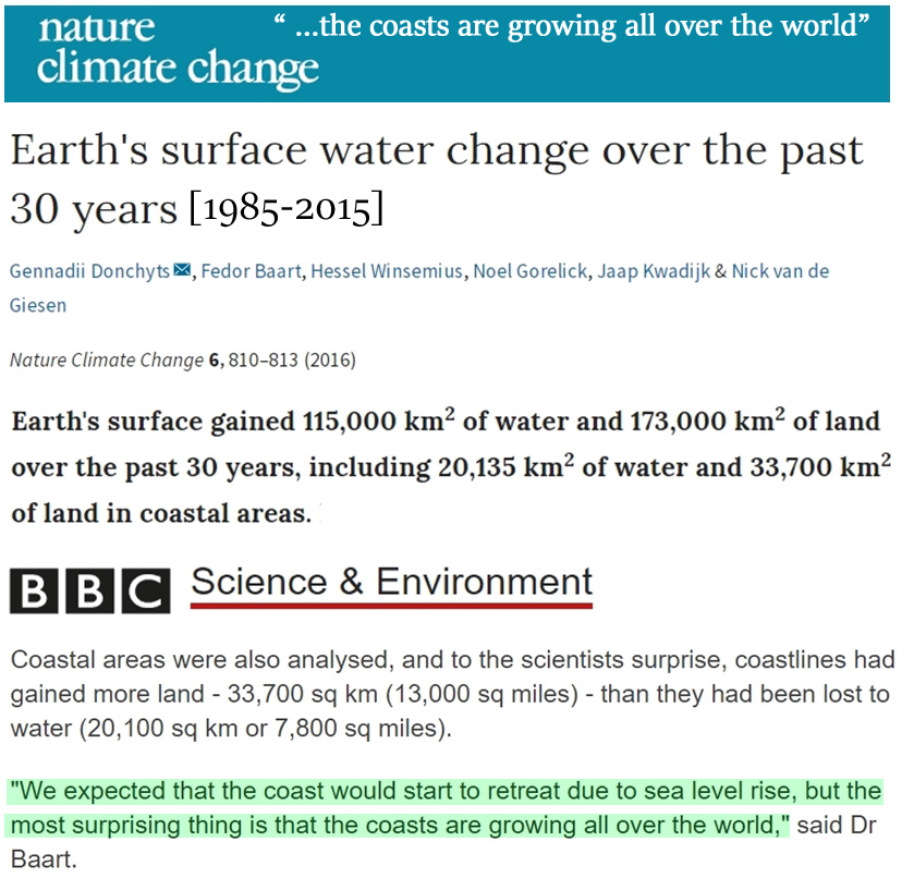
--> Earth's surface water change over the past 30 years
Paywall, and not even an article, it’s a commentary … the opening paragraph does not support your claims …
FAIL …
The claims are supported....
[image deleted by me]
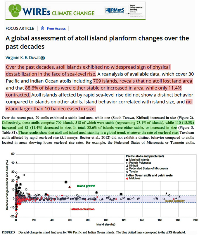
“Earth’s surface gained 115,000 km2 of water and 173,000 km2 of land over the past 30 years, including 20,135 km2 of water and 33,700 km2 of land in coastal areas.”
The fail is all yours...
Let's see if we have this straight ... there was a
GAIN of 115,000 km^2 of water area and a
GAIN of 173,000 km^2 of land area ...
HAW HAW HAW HAW HAW HAW HAW HAW HAW HAW HAW HAW ...
What a moron ... did we LOSE 288,000 km^2 of air area or something ... the article is about something else, you're just going to have to pay the $9 and read it yourself ...
The rest is much of the same ... go on with the other links ... I'm waiting ...
Not sure what you are finding so difficult to grasp about this...but lets see if we can make it even more clear for you although I don't see how much more clear it could be than one of the authors of the paper saying "We expected that the coast would start to retreat due to sea level rise, but the most surprising thing is that the coasts are growing all over the world...
I made the claim that the globe's islands are growing.....my statement is supported...if coastal areas, islands included are gaining more land than they are losing to water....then they are growing..how difficult is that?
The evidence hardly stops there though...I hate to repeat, but since you didn't get it the first time, maybe a second look might help.
Error - Cookies Turned Off
Physical modelling of the response of reef islands to sea-level rise | Geology | GeoScienceWorld
While this is based on a model, there are observations to back up the findings....
“Here, we present evidence from physical model experiments of a reef island that demonstrates
islands have the capability to morphodynamically respond to rising sea level through island accretion. Challenging outputs from existing models based on the assumption that islands are geomorphologically inert, results demonstrate that
islands not only move laterally on reef platforms, but overwash processes provide a mechanism to build and maintain the freeboard of islands above sea level.
Implications of island building are profound, as it will offset existing scenarios of dramatic increases in island flooding. Future predictive models must include the morphodynamic behavior of islands to better resolve flood impacts and future island vulnerability.”
https://www.worldscientific.com/doi/abs/10.1142/9789811204487_0080
“Coral reef islands are unconsolidated deposits of reef-derived sand and gravel that are considered vulnerable to the impacts of global sea-level rise because of their low elevation (< 3 m) and exposure oceanic wave energy. Previous research has shown that sea-level rise will drive an increase in wave overtopping on reef island shorelines, which will be an increasing hazard for atoll island communities. Here, we show that wave overtopping on reef islands is a geomorphically important process that facilitates sediment deposition on the island surface and vertical building.
Field evidence from 26 overwash deposits show that vertical island accretion can be driven by king tides, long-period swell, local storms, tropical cyclones and tsunami. Deposit depths ranged between 0.06–1.93 m and increased island elevations by between 4–400%.
Recognition that overwash processes can contribute to vertical island building is instructive in considering the potential for islands to adjust to future increases in sea-level and to incorporate this critical morphodynamic response in future flood risk modelling for low islands.”
Physical modelling of reef island topographic response to rising sea levels - ScienceDirect
“[R]esults show that the rate and magnitude of physical adjustment is strongly dependent on the rate and magnitude of sea-level rise and wave conditions.
Results challenge existing models of future island susceptibility to wave driven flooding, demonstrating that washover processes can provide a mechanism to build and potentially maintain island freeboard above sea level. These insights highlight an urgent need to incorporate island morphodynamics into flood risk models in order to produce accurate assessments of future wave-driven flood risks and better resolve island vulnerability.”
https://www.worldscientific.com/doi/abs/10.1142/9789811204487_0088
“Low-lying coral reef islands are considered extremely vulnerable to the impacts of climate change. However, future island morphodynamic adjustments in response to anticipated sea level rise and changing wave conditions are currently poorly resolved. Assertions of island vulnerability are based on outputs from flood risk models that simulate sea level rise on present day island topography despite evidence that many reef islands are highly dynamic landforms. Utilizing a physical modelling methodology, three experiment programs were undertaken to model gravel island morphodynamics in response to increasing sea level and changing wave conditions. Modelling outputs present new insights into the modes and styles of island change, primarily the first experimental evidence that
reef islands can keep pace with sea level rise through island building driven by washover processes.
Results suggest that many islands are less vulnerable to inundation than currently perceived and may endure on reef platforms despite sea level rise.”
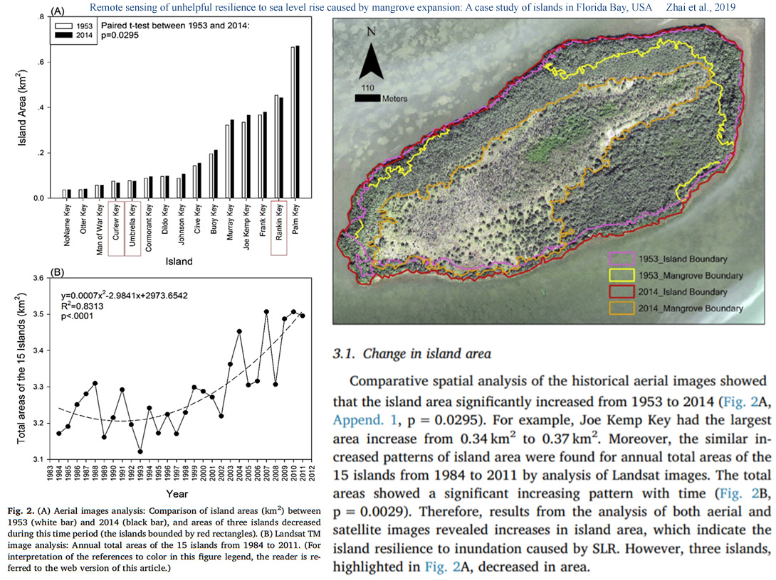
Remote sensing of unhelpful resilience to sea level rise caused by mangrove expansion: A case study of islands in Florida Bay, USA - ScienceDirect
“To estimate the resilience influences on 15 islands in Florida Bay (Florida, U.S.), our study used indicators (areas of the 15 islands and their mangrove forests) by analyzing 61-yr high-resolution historical aerial photographs and a 27-yr time-series of Landsat images.”
“Comparative spatial analysis of the historical aerial images showed that the island area significantly increased from 1953 to 2014. For example, Joe Kemp Key had the largest area increase from 0.34 km2 to 0.37 km2. Moreover, the similar increased patterns of island area were found for annual total areas of the 15 islands from 1984 to 2011 by analysis of Landsat images. The total areas showed a significant increasing pattern with time. Therefore, results from the analysis of both aerial and satellite images revealed increases in island area, which indicate the island resilience to inundation caused by SLR. However, three islands […] decreased in area.”
“The long-term island area increases estimated by our analysis supported the resilience of Florida Bay islands to SLR inundation. Moreover, both the positive relationship between the increases of island area and mangrove expansion, and previous field studies in the Florida Bay and nearby Caribbean mangroves suggested the contribution of the mangrove expansion were at the expense of non-mangrove habitats.”
The fact is, and the studies show that overall, the globe's islands, are in fact growing.