"One of the most vivid predictions of global warming theory is a “hotspot” in the tropical upper troposphere, where increased tropical convection responding to warming sea surface temperatures (SSTs) is supposed to cause enhanced warming in the upper troposphere.
The trouble is that radiosonde (weather ballons) and satellites have failed to show evidence of a hotspot forming in recent decades. Instead, upper tropospheric warming approximately the same as surface warming has been observed...."
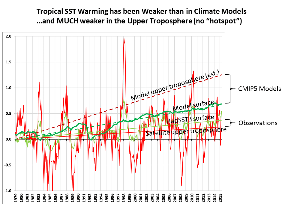
"...Note that the linear warming trend in the UT product (+0.07 C/decade, bright red trend line) is less than the HadSST3 sea surface temperature trend (light green, +0.10 C/decade) for the same 20N-20S latitude band, whereas theory would suggest it should be about twice as large (+0.20 C/decade).
And what is really striking in the above plot is how strong the climate models’ average warming trend over the tropical oceans is in the upper troposphere (+0.35 C/decade, dark red), which I calculate to be about 1.89 times the models’ average surface trend (+0.19 C/decade, dark green). This ratio of 1.89 is based upon the UT weighting function applied to the model average temperature trend profile from the surface to 100 mb (16 km) altitude.
So, what we see is that the models are off by about a factor of 2 on surface warming, but maybe by a factor of 5 (!) for upper tropospheric warming.
This is all preliminary, of course, since we still must submit our Version 6 paper for publication. So, make of it what you will.
But I am increasingly convinced that the hotspot really has gone missing. And the reason why (I still believe) is most likely related to water vapor feedback and precipitation processes, which largely govern the total heat budget of the free-troposphere (the layer above the turbulently mixed boundary layer).
I believe the missing hotspot is indirect evidence that upper tropospheric water vapor is not increasing, and so upper tropospheric water vapor (the most important layer for water vapor feedback) is not amplifying warming from increasing CO2. The fact that UT warming is indeed amplified — by about a factor of 2 — during El Nino events in the above plot might be related to the relatively short time scales involved, since convective heating and radiative cooling are far out of balance during short term variations, but are much closer to being balanced in the long-term with global warming.
The lack of positive water vapor feedback is an especially controversial assertion to make, given that (1) SSM/I satellite measurements of water vapor have indeed been increasing in lock-step with SST warming, and (2) probably a unanimous opinion in the IPCC climate community that water vapor feedback is positive.
But the SSM/I measurements are largely insensitive to the very low levels of upper tropospheric water vapor, so they can’t tell us anything about upper tropospheric vapor. And while lower-tropospherc water vapor is governed mostly by SST, upper tropospheric vapor is governed by precipitation processes, and we don’t even understand how those might change with warming, let alone have those physics included in climate models.
Instead, I suspect the models have been adjusted so that precipitation systems detrain more water vapor into the upper troposphere with warming, simply because that’s what we see on short time scales, say during El Nino events, and so the convective parameterizations in the models are adjusted to meet that expectation..."
New Satellite Upper Troposphere Product: Still No Tropical “Hotspot” « Roy Spencer, PhD
The trouble is that radiosonde (weather ballons) and satellites have failed to show evidence of a hotspot forming in recent decades. Instead, upper tropospheric warming approximately the same as surface warming has been observed...."
"...Note that the linear warming trend in the UT product (+0.07 C/decade, bright red trend line) is less than the HadSST3 sea surface temperature trend (light green, +0.10 C/decade) for the same 20N-20S latitude band, whereas theory would suggest it should be about twice as large (+0.20 C/decade).
And what is really striking in the above plot is how strong the climate models’ average warming trend over the tropical oceans is in the upper troposphere (+0.35 C/decade, dark red), which I calculate to be about 1.89 times the models’ average surface trend (+0.19 C/decade, dark green). This ratio of 1.89 is based upon the UT weighting function applied to the model average temperature trend profile from the surface to 100 mb (16 km) altitude.
So, what we see is that the models are off by about a factor of 2 on surface warming, but maybe by a factor of 5 (!) for upper tropospheric warming.
This is all preliminary, of course, since we still must submit our Version 6 paper for publication. So, make of it what you will.
But I am increasingly convinced that the hotspot really has gone missing. And the reason why (I still believe) is most likely related to water vapor feedback and precipitation processes, which largely govern the total heat budget of the free-troposphere (the layer above the turbulently mixed boundary layer).
I believe the missing hotspot is indirect evidence that upper tropospheric water vapor is not increasing, and so upper tropospheric water vapor (the most important layer for water vapor feedback) is not amplifying warming from increasing CO2. The fact that UT warming is indeed amplified — by about a factor of 2 — during El Nino events in the above plot might be related to the relatively short time scales involved, since convective heating and radiative cooling are far out of balance during short term variations, but are much closer to being balanced in the long-term with global warming.
The lack of positive water vapor feedback is an especially controversial assertion to make, given that (1) SSM/I satellite measurements of water vapor have indeed been increasing in lock-step with SST warming, and (2) probably a unanimous opinion in the IPCC climate community that water vapor feedback is positive.
But the SSM/I measurements are largely insensitive to the very low levels of upper tropospheric water vapor, so they can’t tell us anything about upper tropospheric vapor. And while lower-tropospherc water vapor is governed mostly by SST, upper tropospheric vapor is governed by precipitation processes, and we don’t even understand how those might change with warming, let alone have those physics included in climate models.
Instead, I suspect the models have been adjusted so that precipitation systems detrain more water vapor into the upper troposphere with warming, simply because that’s what we see on short time scales, say during El Nino events, and so the convective parameterizations in the models are adjusted to meet that expectation..."
New Satellite Upper Troposphere Product: Still No Tropical “Hotspot” « Roy Spencer, PhD
Last edited: