Recent observations below the ice sheet at the boundaries of Antarctic glaciers have been able to measure the rate of retreat of the glacier's grounding line. That rate far exceeds any prior estimates of a maximum rate for such movement. This further increases the odds of a catastrophic collapse of Antarctic ice sheets whose weight has forced their bedrock below sea level.
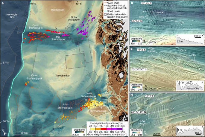
Analysis of more than 7,600 corrugation ridges on the Norwegian continental shelf shows that rapid grounding-line retreat of several hundred metres per day occurred across low-gradient ice-sheet beds during the last deglaciation.

www.nature.com
Abstract
Rates of ice-sheet grounding-line retreat can be quantified from the spacing of corrugation ridges on deglaciated regions of the seafloor
1,
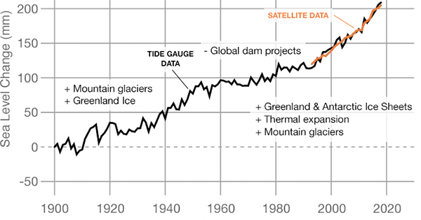
2, providing a long-term context for the approximately 50-year satellite record of ice-sheet change
3,
4,
5. However, the few existing examples of these landforms are restricted to small areas of the seafloor, limiting our understanding of future rates of grounding-line retreat and, hence, sea-level rise. Here we use bathymetric data to map more than 7,600 corrugation ridges across 30,000 km2 of the mid-Norwegian shelf. The spacing of the ridges shows that pulses of rapid grounding-line retreat, at rates ranging from 55 to 610 m day−1, occurred across low-gradient (±1°) ice-sheet beds during the last deglaciation. These values far exceed all previously reported rates of grounding-line retreat across the satellite
3,
4,
6,
7 and marine-geological
1,
2 records. The highest retreat rates were measured across the flattest areas of the former bed, suggesting that near-instantaneous ice-sheet ungrounding and retreat can occur where the grounding line approaches full buoyancy. Hydrostatic principles show that pulses of similarly rapid grounding-line retreat could occur across low-gradient Antarctic ice-sheet beds even under present-day climatic forcing. Ultimately, our results highlight the often-overlooked vulnerability of flat-bedded areas of ice sheets to pulses of extremely rapid, buoyancy-driven retreat.


%20(1).jpeg?disposition=inline)