Navigation
Install the app
How to install the app on iOS
Follow along with the video below to see how to install our site as a web app on your home screen.
Note: This feature may not be available in some browsers.
More options
Style variation
You are using an out of date browser. It may not display this or other websites correctly.
You should upgrade or use an alternative browser.
You should upgrade or use an alternative browser.
NASA: Unprecedented melting of Greenland's ice sheet
- Thread starter Star
- Start date
SSDD
Gold Member
- Nov 6, 2012
- 16,672
- 1,968
- 280
I have posted UC's sea level data repeatedly. So, Dude, I suggest you accept established facts and stop acting like a complete fool.
PS, the Everglades now has crocodiles; a saltwater species.
Does the word brackish mean anything to you ?
jc456
Diamond Member
- Dec 18, 2013
- 158,761
- 39,231
- 2,180
posting fudge as data does me no good. I stated, and I didn't stutter, name a coastline that has been affected by sea rise? why do you always want to bat .000?I have posted UC's sea level data repeatedly. So, Dude, I suggest you accept established facts and stop acting like a complete fool.
PS, the Everglades now has crocodiles; a saltwater species.
jc456
Diamond Member
- Dec 18, 2013
- 158,761
- 39,231
- 2,180
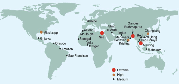
dude, you are one of the most nagging little nats on the board. Again, we've already been through the Marshall islands and they don't qualify based on the Atoll properties of them, so they are a fail as I have pointed out to you repeatedly in this forum.1) The coastline of the Marshall Islands.
2)
3)
Second, a picture does nothing for me. so post a story stupid parrot to a location off your picture where they claim sea level rise. Jeopardy song is playing.
jc456
Diamond Member
- Dec 18, 2013
- 158,761
- 39,231
- 2,180
not a cartoon, nope never will be.Nothing I ever post will be acceptable to you because of your prejudice. I posted that information simply to prove to other viewers that you don't know what the **** you're talking about.
Old Rocks
Diamond Member
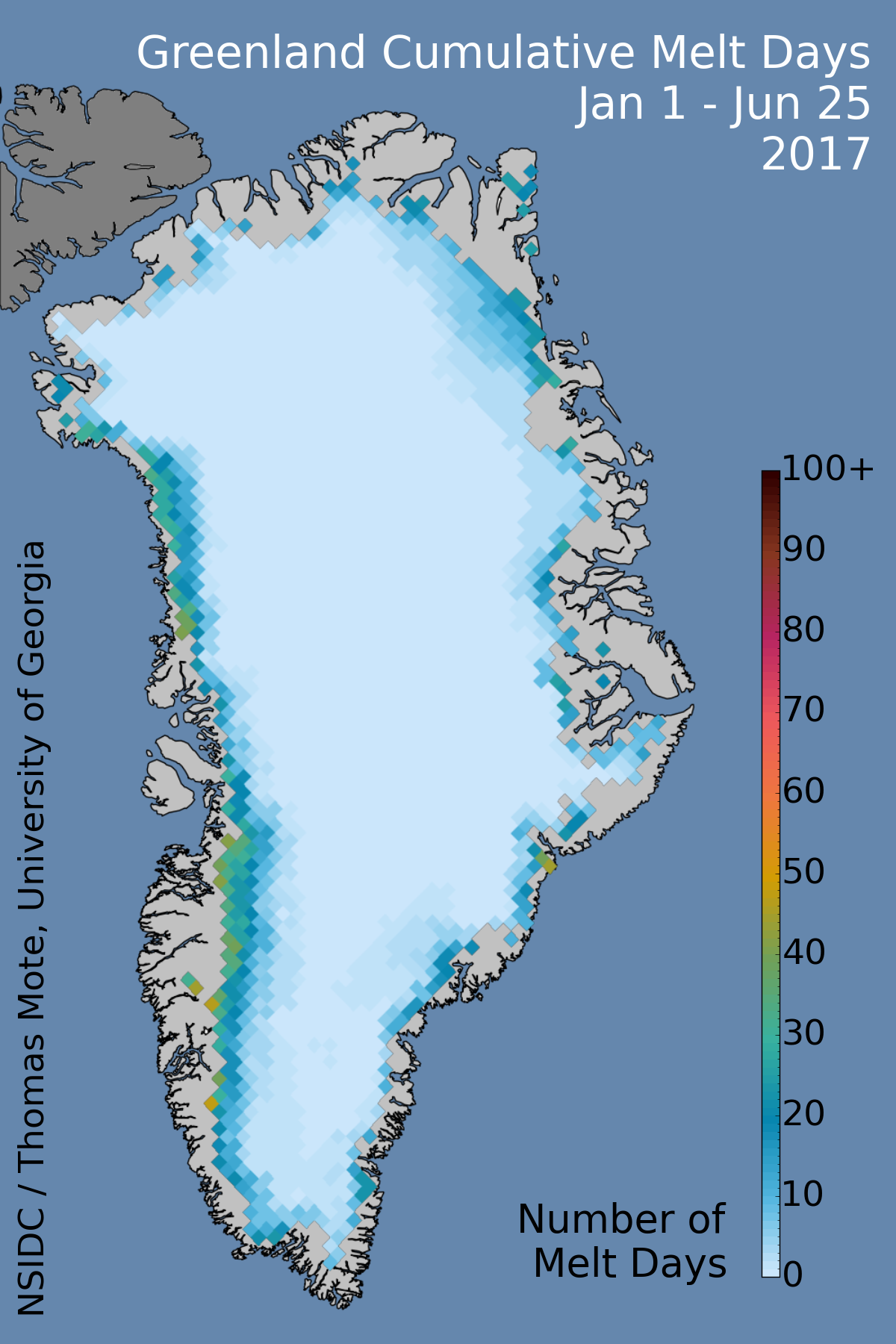
Get satellite images and information about melting on the Greenland ice sheet. Images are updated daily, and we post analysis periodically as conditions warrant.
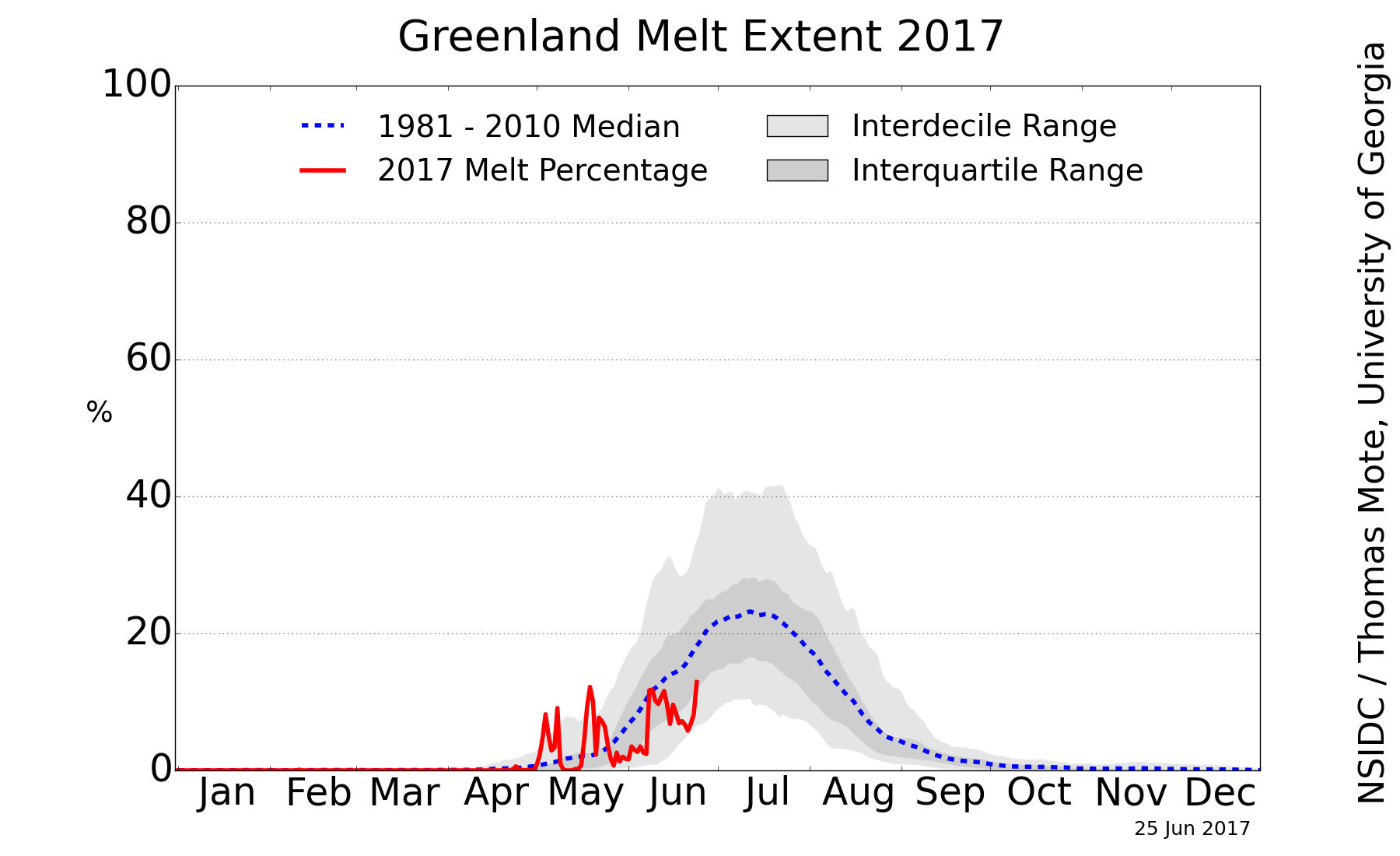
Click an image for a high-resolution version.
Greenland Ice Sheet Today | Surface Melt Data presented by NSIDC
Low points followed the 1981-2010 average, some of the high points outside the high 2 standard deviation line. A high melt year this year.
Old Rocks
Diamond Member
Not only does this not belong in this thread, the Marshall Islands are a thousand miles from the nearest subduction zone. LaDumbkopf just keeps repeating the same lie, even when it was shown to him on a map.The Marshall islands are right on the lip of the Pacific Ring of Fire and will be under-the-crust lava in 2-3 million years...
The Marshall islands are right on the lip of the Pacific Ring of Fire and will be under-the-crust lava in 2-3 million years...
You're bound and determined, I see, to continue making yourself look like a fool. The Marshalls are NOT on the lip of the Pacific Plate, they are 1,384 miles away from the nearest such trench and are not being subducted into the Earth. Your suggestion that the entire plate sinks at once would have been rejected by a sixth grader. For someone who has based his entire thesis on geological phenomenon, your knowledge of very basic geology is woeful.
And, as Old Rocks has pointed out, this is completely off topic for this thread.
not a cartoon, nope never will be.Nothing I ever post will be acceptable to you because of your prejudice. I posted that information simply to prove to other viewers that you don't know what the **** you're talking about.
Like your Popeye avatar? I don't know what you intended to say here.
LOL!!!
Parroting something doesn't mean you understand what you are parroting.
Indeed, your freudian slip to the Marshalls there was pretty hilarious...
Freudian slip? I bet many jokes have to be explained to you.
jc456
Diamond Member
- Dec 18, 2013
- 158,761
- 39,231
- 2,180
Already explained the behavior of an atoll.LOL!!!
Parroting something doesn't mean you understand what you are parroting.
Indeed, your freudian slip to the Marshalls there was pretty hilarious...
Freudian slip? I bet many jokes have to be explained to you.
- Banned
- #97
The Marshalls are NOT on the lip of the Pacific Plate, they are 1,384 miles away from the nearest such trench and are not being subducted into the Earth.
Like the fudgebakers you parrot here daily, you lie like a left winger...
_(Polynesia_centered).svg/2000px-Marshall_Islands_on_the_globe_(small_islands_magnified)_(Polynesia_centered).svg.png)

crick wants you to believe that somehow only parts of the PROF engage in subduction, that the bottom of the Pacific Ocean only goes under from Japan to the Philippines, and the rest just vanishes in the transporter room of the Enterprise. In reality, the entire plate is subducting, and just because the Marshalls are on a slanted portion of the PROF does not mean they are not sinking and soon to be sub crust lava.
THE WHOLE PLATE subducts, crick, not CHERRY PICKED portions of it
LordBrownTrout
Diamond Member
Unprecedented melting of Greenland's ice sheet this month has stunned NASA scientists and has highlighted broader concerns that the region is losing a remarkable amount of ice overall.
According to a NASA press release, about half of Greenland's surface ice sheet naturally melts during an average summer. But the data from three independent satellites this July, analyzed by NASA and university scientists, showed that in less than a week, the amount of thawed ice sheet surface skyrocketed from 40 percent to 97 percent.
In over 30 years of observations, satellites have never measured this amount of melting, which reaches nearly all of Greenland's surface ice cover.
When Son Nghiem of NASA's Jet Propulsion Laboratory observed the recent melting phenomenon, he said in the NASA press release, "This was so extraordinary that at first I questioned the result: Was this real or was it due to a data error?"
Scientists at NASA's Goddard Space Flight Center, University of Georgia-Athens and City University of New York all confirmed the remarkable ice melt.
NASA's cryosphere program manager, Tom Wagner, credited the power of satellites for observing the melt and explained to The Huffington Post that, although this specific event may be part of a natural variation, "We have abundant evidence that Greenland is losing ice, probably because of global warming, and it's significantly contributing to sea level rise."
Wagner said that ice is clearly thinning around the periphery, changing Greenland's overall ice mass, and he believes this is primarily due to warming ocean waters "eating away at the ice." He cautiously added, "It seems likely that's correlated with anthropogenic warming."
This specific extreme melt occurred in large part due to an unusual weather pattern over Greenland this year, what the NASA press release describes as a series of "heat domes," or an "unusually strong ridge of warm air."
Notable melting occurred in specific regions of Greenland, such as the area around Summit Station, located two miles above sea level. Not since 1889 has this kind of melting occurred, according to ice core analysis described in NASA's press release.
Goddard glaciologist Lora Koenig said that similar melting events occur about every 150 years, and this event is consistent with that schedule, citing the previous 1889 melt. But, she added, "if we continue to observe melting events like this in upcoming years, it will be worrisome."
"One of the big questions is 'What's happening in the Arctic in general?'" Wagner said to HuffPost.
Just last week, another unusual event occurred in the region: the calving of an iceberg twice the size of Manhattan from Greenland's Petermann Glacier.
Over the past few months, separate studies have emerged that suggest humans are playing a "dominant role" in ocean warming, and that specific regions of the world, such as the U.S. East Coast, are increasingly vulnerable to sea level rise.
Wagner explained that in recent years, studies have observed thinning sea ice and "dramatic" overall changes. He was clear, "We dont want to lose sight of the fact that Greenland is losing a tremendous amount of ice overall."
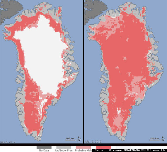
NASA CAPTION: Extent of surface melt over Greenlands ice sheet on July 8 (left) and July 12 (right). Measurements from three satellites showed that on July 8, about 40 percent of the ice sheet had undergone thawing at or near the surface. In just a few days, the melting had dramatically accelerated and an estimated 97 percent of the ice sheet surface had thawed by July 12. In the image, the areas classified as probable melt (light pink) correspond to those sites where at least one satellite detected surface melting. The areas classified as melt (dark pink) correspond to sites where two or three satellites detected surface melting. The satellites are measuring different physical properties at different scales and are passing over Greenland at different times. As a whole, they provide a picture of an extreme melt event about which scientists are very confident. Credit: Nicolo E. DiGirolamo, SSAI/NASA GSFC, and Jesse Allen, NASA Earth Observatory
Has nothing to do with us causing. To believe that is pure insanity , arrogance, and ignorance.
jc456
Diamond Member
- Dec 18, 2013
- 158,761
- 39,231
- 2,180
And again, causing what?Then what do you believe is causing it? Solar irradiance is down significantly. Greenhouse warming is up. Why are you so certain we aren't to blame?
The planet rotates, there is conduction and convection, wind, jet streams moving our air around. We have Ninos and nina's. So what exactly is cause of what?
Similar threads
- Replies
- 264
- Views
- 3K
- Replies
- 62
- Views
- 785
- Replies
- 4
- Views
- 145
New Topics
-
 Most Americans say: operation successful, 90% or MAGA supports it (on Islamic Republic)
- Started by Pastelli
- Replies: 12
-

-

-
 putin lawmaker claims Ukraine is using “Terminator robots” in combat
- Started by Litwin
- Replies: 0