Munging The Sea Level Data

Sunsettommy

Diamond Member
Mar 19, 2018
14,891
12,525
2,400
It appears the Satellite Sea level data is faulty, due to something they assumed on with absurd claims of high accuracy.


Watts Up With That?

Munging The Sea Level Data

2/21/2021

Guest Post by Willis Eschenbach

Excerpt:

mung
/mənj/ [pronounced “munge”]
verb
INFORMAL•COMPUTING
gerund or present participle: munging

to manipulate (data)
EXAMPLE: “you could do what anti-spammers have done for years and mung the URLs”

For more than a decade now, I’ve been wondering about a couple of questions.

First, why does the satellite-based sea-level data show that the sea level is rising so much faster than the rise measured at tidal stations on the coastlines around the world? Records from tidal stations show a rise on the order of a couple of mm per year, a rate which is little changed over the century or so for which we have adequate records. But the satellite record (Figure 1) shows a rise of 3.3 mm/year. Why the large difference?


Second, why does the satellite-based sea-level show such significant acceleration? As mentioned above, the sea-level records from tidal stations, which are much longer, show little or no acceleration. But the satellite record claims that the rate of sea-level rise is increasing by about a tenth of an mm per year. That amount of acceleration would double the rate of sea-level rise in about thirty years. Again, why the large difference?

To start with, here’s what the satellite data says, according to the University of Colorado Sea Level Research Group.

LINK

I can answer Willies 1st question, Because most long term tidal records are measured at coastline. Not really an indication of true sea level..

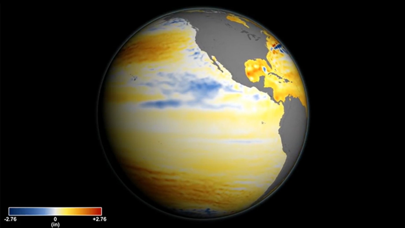
Breaking news.. The ocean IS NOT FLAT. And the coastline is not where it needs to be measured. If you LOOK at a map of sea level in the Pacific, you'll see HEAP of central ocean waters that are 4 or 5 times the 3mm/year. Currents and prevailing winds do this..

His 2nd question about the .1mm acceleration could be wetter climate and INCREASING runoff from land mass URBANIZING or flood control efforts. OR -- it could be some melting ice. Or some aging and calibration issue with the satellites..

I don't want a climate really where legacy ice is GROWING.. Most people dont. Pretty sure this space measurement technique is only about 2 decades old. That's not LONG ENOUGH to quantify an accurate "acceleration" of .1mm/yr.. It's probably in the noise level of the measurements.
 
Last edited:
Or -- they are allowing the sats to drift 0.1mm lower each year !!!! :auiqs.jpg:

Here is what Oceanographer Josh Wills says about it:


"Sentinel-6 will orbit about 800 miles up and use radar to measure the surface of the ocean. An instrument on the satellite sends a radar wave down to Earth. The radar bounces off the surface of the ocean and returns to the satellite. By measuring how long it took for the radar to go down and back — and accounting for moisture in the atmosphere which slows the radar down — scientists can measure how far away the surface of the ocean is from the satellite.

In other words, the satellite can tell scientists on Earth how high the oceans are, and how that height is changing over time.

“It’s really kind of an incredible feat of technology,” [Josh] Willis says. “We can accurately measure the water level with an accuracy of 1 inch from 800 miles up.”


bolding mine

===


Willis E. goes on to show how absurd the numbers are:

"An accuracy of 1 inch, that’s 25.4 mm … and they’re claiming they know the annual change in the volume of the oceans from the GIA to the nearest tenth of an mm of sea level height? I know that accuracy is different from precision, and that measurement of changes in length over time (precision) can be an order of magnitude better than the measurements of the length itself (accuracy), but still … sorry, but I’m not buying the GIA claim.

Let me see if I can give you a sense of the difficulty of the satellite measurements of sea level. The satellites orbit at an altitude of about 830 miles, which is about 1.34 billion millimetres. So to measure the change in sea level to the nearest tenth of an mm, we’d need to be able to measure the distance from the satellite to the sea surface to a precision greater than one part in thirteen billion … and that is a hard challenge even in a controlled laboratory setting."
 
The ocean IS NOT FLAT

I learned that one the hard way!

seasick.00.jpg
 
It appears the Satellite Sea level data is faulty, due to something they assumed on with absurd claims of high accuracy.


Watts Up With That?

Munging The Sea Level Data

2/21/2021

Guest Post by Willis Eschenbach

Excerpt:

mung
/mənj/ [pronounced “munge”]
verb
INFORMAL•COMPUTING
gerund or present participle: munging

to manipulate (data)
EXAMPLE: “you could do what anti-spammers have done for years and mung the URLs”

For more than a decade now, I’ve been wondering about a couple of questions.

First, why does the satellite-based sea-level data show that the sea level is rising so much faster than the rise measured at tidal stations on the coastlines around the world? Records from tidal stations show a rise on the order of a couple of mm per year, a rate which is little changed over the century or so for which we have adequate records. But the satellite record (Figure 1) shows a rise of 3.3 mm/year. Why the large difference?


Second, why does the satellite-based sea-level show such significant acceleration? As mentioned above, the sea-level records from tidal stations, which are much longer, show little or no acceleration. But the satellite record claims that the rate of sea-level rise is increasing by about a tenth of an mm per year. That amount of acceleration would double the rate of sea-level rise in about thirty years. Again, why the large difference?

To start with, here’s what the satellite data says, according to the University of Colorado Sea Level Research Group.

LINK

I can answer Willies 1st question, Because most long term tidal records are measured at coastline. Not really an indication of true sea level..

Breaking news.. The ocean IS NOT FLAT. And the coastline is not where it needs to be measured. If you LOOK at a map of sea level in the Pacific, you'll see HEAP of central ocean waters that are 4 or 5 times the 3mm/year. Currents and prevailing winds do this..

His 2nd question about the .1mm acceleration could be wetter climate and INCREASING runoff from land mass URBANIZING or flood control efforts. OR -- it could be some melting ice. Or some aging and calibration issue with the satellites..

I don't want a climate really where legacy ice is GROWING.. Most people dont. Pretty sure this space measurement technique is only about 2 decades old. That's not LONG ENOUGH to quantify an accurate "acceleration" of .1mm/yr.. It's probably in the noise level of the measurements.
So coastal cities like Miami don’t have to worry? The actual levels aren’t real? Sounds strange
 
Time will resolve this question.

If the rise in sea level is accelerating then no one will be able to deny the acceleration after ten years of acceleration. It will be obvious.

If the rise in sea level is not accelerating then no one will be able to deny the sea level is not accelerating after ten years of no acceleration. It will be obvious.
 
My money is on the rise remaining at a constant ~3 mm/yr; the same as it has been for the past ~6000 years until such time when it starts to fall when the next cooling cycle starts. We are in an ice age after all with nations wanting to make the planet colder.
 
Time will resolve this question.

If the rise in sea level is accelerating then no one will be able to deny the acceleration after ten years of acceleration. It will be obvious.

If the rise in sea level is not accelerating then no one will be able to deny the sea level is not accelerating after ten years of no acceleration. It will be obvious.
It’s been thirty years and science was wrong yet the idiots continue with their nonsense
I agree. You'd think if man had been causing the planet to warm for the past 200 years that the rise in sea level would have risen significantly above 3 mm/yr by now.
Or, they’d have evidence, the thing scientists say is needed
 
Or -- they are allowing the sats to drift 0.1mm lower each year !!!! :auiqs.jpg:

Here is what Oceanographer Josh Wills says about it:


"Sentinel-6 will orbit about 800 miles up and use radar to measure the surface of the ocean. An instrument on the satellite sends a radar wave down to Earth. The radar bounces off the surface of the ocean and returns to the satellite. By measuring how long it took for the radar to go down and back — and accounting for moisture in the atmosphere which slows the radar down — scientists can measure how far away the surface of the ocean is from the satellite.

In other words, the satellite can tell scientists on Earth how high the oceans are, and how that height is changing over time.

“It’s really kind of an incredible feat of technology,” [Josh] Willis says. “We can accurately measure the water level with an accuracy of 1 inch from 800 miles up.”

bolding mine

===


Willis E. goes on to show how absurd the numbers are:

"An accuracy of 1 inch, that’s 25.4 mm … and they’re claiming they know the annual change in the volume of the oceans from the GIA to the nearest tenth of an mm of sea level height? I know that accuracy is different from precision, and that measurement of changes in length over time (precision) can be an order of magnitude better than the measurements of the length itself (accuracy), but still … sorry, but I’m not buying the GIA claim.

Let me see if I can give you a sense of the difficulty of the satellite measurements of sea level. The satellites orbit at an altitude of about 830 miles, which is about 1.34 billion millimetres. So to measure the change in sea level to the nearest tenth of an mm, we’d need to be able to measure the distance from the satellite to the sea surface to a precision greater than one part in thirteen billion … and that is a hard challenge even in a controlled laboratory setting."

So.. possibly the sat system is accelerating towards the earth at a rate 0.1mm per year... Houston-- we have a problem..

:rolleyes:
 
Time will resolve this question.

If the rise in sea level is accelerating then no one will be able to deny the acceleration after ten years of acceleration. It will be obvious.

If the rise in sea level is not accelerating then no one will be able to deny the sea level is not accelerating after ten years of no acceleration. It will be obvious.

My specialty is signal and image processing. I've pulled signals and images out of noise and interference that nobody's ever seen before.. It's not impossible to see into the noise levels. But you're correct. Patterns and signals in noise appear over time thru averaging and advanced filtering techniques.
 
The ocean IS NOT FLAT

I learned that one the hard way!

View attachment 460223

I learned from old bearded pirate the trick.. It was after a full day tuna fishing excursion and I was doing fine until the galley started cooking up steak and fries. The smell was setting me off.

I told this pirate cook I shouldn't eat. He told me "Eat or hug the railings matey".. And he was right..
 
Time will resolve this question.

If the rise in sea level is accelerating then no one will be able to deny the acceleration after ten years of acceleration. It will be obvious.

If the rise in sea level is not accelerating then no one will be able to deny the sea level is not accelerating after ten years of no acceleration. It will be obvious.

My specialty is signal and image processing. I've pulled signals and images out of noise and interference that nobody's ever seen before.. It's not impossible to see into the noise levels. But you're correct. Patterns and signals in noise appear over time thru averaging and advanced filtering techniques.
I am approaching this from a different angle. If sea level rise is accelerating versus rising at a constant rate than the change in rise over time will be easy to see as time increases.

d = vt

versus

d = vt + 1/2at^2

They can only wave their arms for so long before put up turns into shut up.


Forum List

Back
Top