How Low Will It GO???

I looked at historical temps for my area going back to the 1970's.
Seems things are a lot more stable and consistent than any of the hype is saying.;

Occasional cold snaps, winter storms and heat waves are the norm.
We are actually returning to a more wet flow aloft.

The only major item that concerns me is the continued lack of energy being stored up in our oceans. It's a coin toss as to there being another La Niña or just a very neutral ENSO until the next major dip in temperatures. This moderating ocean temperature should swing more water over the western US.
 
You just can't beat Butter-crunch bib lettuce! Or Great Lakes leaf lettuce. Huge leaves!

Black-seeded Simpson has a weedy nature here ... what to eat over-winter ... I plant a bit of a row every month of so ... global warming raise the probability of a successful crop ...
 
We are actually returning to a more wet flow aloft.

The only major item that concerns me is the continued lack of energy being stored up in our oceans. It's a coin toss as to there being another La Niña or just a very neutral ENSO until the next major dip in temperatures. This moderating ocean temperature should swing more water over the western US.

What I don't get is why 75 mph wind gusts only gets us a lousy wind advisory ... piss yellow color ... winter storm warnings up everyplace else ... bright shiny pink ... 75 mpg wind gusts just gets an advisory ...

There's a screw loose someplace ...
 
What I don't get is why 75 mph wind gusts only gets us a lousy wind advisory ... piss yellow color ... winter storm warnings up everyplace else ... bright shiny pink ... 75 mpg wind gusts just gets an advisory ...

There's a screw loose someplace ...
Thats just stiff breeze up here... suck it up... :)
 
Media is reporting 106 mph in the Bay Area today ... yesh ... we get that along the headlands, but no one lives there ...
I have several family members in the Bay area and we have been unable to get in touch with any of them.
 
Was looking over historical data and found that the US-CRN posted a very large drop in tempratures last month.

USCRN-Tavg-Nov22.png

Given the events of the last week or two we should see another massive drop in land-based temperatures once again. IF it were done today the average would be -4.13 degrees F. From the current charting we have been cooling since 2011.

It's going to get really interesting once the December average comes in. How low will it go?
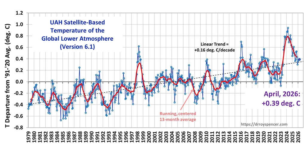
C2ilPQnUQAAUuFy.jpg
 

Latest Discussions

Back
Top Bottom