Global warming doesn't exist.
A snowstorm, in an island near the equator in the Spring.
But hey, don't believe me. You could look at the global temperatures being below average for the past 3 years, SST's being below average, huge spring storms (which means there's a lot of cold air to work with) in the US.. you know, all of that.
Is this where you get your "global cooling" data?
It's official: New global cooling trend caused by Somalia pirates! | the Beijinger Forum | Environmental Issues | Jan 11, 2009 | thebeijinger.com
If you open your ignorant mouth without thinking you sound like a stupid shit, what a fool!
There's a ski area on Hawaii, it snows all the time on the big island.
Hawaii Ski Club
I'll try to keep this basic so you can keep up; when the temperature increases, more water evaporates into the atmosphere which will fall as rain or snow depending on temperature and elevation.
There are four key elements of weather including
Actually, you little putz, I do understand climate. Thanks for your neg rep. The Earth has cooled over the past couple of years due to a strong La Nina.
History and understanding of ENSO
For several decades, it has been globally known by scientists and forecasters that a phenomenon referred to as ENSO (El Nino-Southern Oscillation) plays a major role in the Earth's weather patterns. This phenomenon has been linked to major precipitation swings in South America, North America, Africa, Australia, and southern Asia. The same is true with extreme temperature trends all over the Earth. Other than a major volcanic eruption, or something extraterrestrial impacting the Earth, the ENSO phenomenon is the most global-impacting event known to man.
Over the years, many studies have been done in an attempt to better identify and forecast ENSO events. With all the research that has been done on the subject, scientists have reached a unified consensus as to what the ENSO event is, and what causes it.
First identified in 1923 by Sir Gilbert Thomas Walker, the El Nino-Southern Oscillation is an ocean-atmosphere phenomenon. El Nino and La Nina are defined as temperature fluctuations in surface waters of the Tropical Pacific Ocean. The name El Nino, comes from the Spanish word for "the little boy", refers to the Christ child, because the phenomenon is usually noticed around Christmas time in the Pacific Ocean. An El Nino is identified when the Tropical Pacific develops a large region of warmer than average surface water. La Nina refers to "the little girl", which is essentially opposite to El Nino. This is identified when the Tropical Pacific develops a large region of colder than average surface water.
A visual showing the difference between classic El Nino and La Nina signatures is shown below.
Identifying an El Nino or La Nina
El Nino and La Nina events are officially defined as "sustained sea surface temperature anomalies of magnitude greater than +0.5°C across the central tropical Pacific Ocean (longitude 170W - 118W; latitude 5S - 5N)". When this condition is met for a period of five or more consecutive months, it is classified as an El Nino or La Nina episode.
Identifying oncoming ENSO events months before the event is declared official is usually done using the steps listed below:
1. Rise in air pressure over the Indian Ocean, Indonesia, and Australia
2. Fall in air pressure over Tahiti and the rest of the central and eastern Pacific Ocean
3. Trade winds in the south Pacific weaken or head east
4. Warm air rises near Peru, causing rain in the deserts there
5. Warm water spreads from the west Pacific and the Indian Ocean to the east Pacific. It takes the rain with it,
causing rainfall in normally dry areas and extensive drought in eastern areas.
---
Ocean Surface Topography from Space-Science
You want proof we've been in a La Nina? Here's your proof you ******* moron:
The last El Nino we were in was 2004-2005.
[FONT=VERDANA,HELVETICA,ARIAL]
SCIENCE - El Niño/La Niña & PDO
[/FONT] Latest El Niño/La Niña Jason Data
[FONT=VERDANA,HELVETICA,ARIAL]
10/31/2004[/FONT]

 [FONT=VERDANA,HELVETICA,ARIAL]Pacific Data[/FONT] [FONT=VERDANA,HELVETICA,ARIAL]Global Data[/FONT]
[FONT=VERDANA,HELVETICA,ARIAL]
What are we looking at? [/FONT]
[FONT=VERDANA,HELVETICA,ARIAL]
These images show sea surface height anomalies with the seasonal cycle (the effects of summer, fall, winter, and spring) removed. The differences between what we see and what is normal for different times and regions are called anomalies, or residuals. When oceanographers and climatologists view these "anomalies" they can identify unusual patterns and can tell us how heat is being stored in the ocean to influence future planetary climate events. Each image is a 10-day average of data, centered on the date indicated.
[/FONT]
More El Nino pictures:
[FONT=VERDANA,HELVETICA,ARIAL]
SCIENCE - El Niño/La Niña & PDO
[/FONT] Latest El Niño/La Niña Jason Data
[FONT=VERDANA,HELVETICA,ARIAL]
12/27/2004[/FONT]


[FONT=VERDANA,HELVETICA,ARIAL]
Now here my friend, is a La Nina developing in 2007:[/FONT]
[FONT=VERDANA,HELVETICA,ARIAL]
SCIENCE - El Niño/La Niña & PDO
[/FONT]
Latest El Niño/La Niña Jason Data
[FONT=VERDANA,HELVETICA,ARIAL]
12/09/2007[/FONT]

 [FONT=VERDANA,HELVETICA,ARIAL]Pacific Data[/FONT] [FONT=VERDANA,HELVETICA,ARIAL]Global Data[/FONT]
[FONT=VERDANA,HELVETICA,ARIAL]
See the difference?[/FONT]
[FONT=VERDANA,HELVETICA,ARIAL]
El Nino - Warm[/FONT]
[FONT=VERDANA,HELVETICA,ARIAL]
La Nina - Cold[/FONT]
[FONT=VERDANA,HELVETICA,ARIAL]
We've been in a La Nina pattern since 2007.[/FONT]
[FONT=VERDANA,HELVETICA,ARIAL]
[/FONT][FONT=VERDANA,HELVETICA,ARIAL]
02/01/2009[/FONT]

 [FONT=VERDANA,HELVETICA,ARIAL]Pacific Data[/FONT] [FONT=VERDANA,HELVETICA,ARIAL]Global Data[/FONT]
[FONT=VERDANA,HELVETICA,ARIAL]
<< BACK
[/FONT][FONT=VERDANA,HELVETICA,ARIAL]
01/14/2009[/FONT]

 [FONT=VERDANA,HELVETICA,ARIAL]Pacific Data[/FONT] [FONT=VERDANA,HELVETICA,ARIAL]Global Data[/FONT]
[FONT=VERDANA,HELVETICA,ARIAL]
<< BACK [/FONT]
[FONT=VERDANA,HELVETICA,ARIAL]
1/30/2008[/FONT]

 [FONT=VERDANA,HELVETICA,ARIAL]Pacific Data[/FONT] [FONT=VERDANA,HELVETICA,ARIAL]Global Data[/FONT]
[FONT=VERDANA,HELVETICA,ARIAL]
<< BACK
[/FONT][FONT=VERDANA,HELVETICA,ARIAL]
11/15/2008[/FONT]

 [FONT=VERDANA,HELVETICA,ARIAL]Pacific Data[/FONT] [FONT=VERDANA,HELVETICA,ARIAL]Global Data[/FONT]
[FONT=VERDANA,HELVETICA,ARIAL]
<< BACK
[/FONT][FONT=VERDANA,HELVETICA,ARIAL]
10/31/2008[/FONT]

 [FONT=VERDANA,HELVETICA,ARIAL]Pacific Data[/FONT] [FONT=VERDANA,HELVETICA,ARIAL]Global Data[/FONT]
[FONT=VERDANA,HELVETICA,ARIAL]
<< BACK
[/FONT][FONT=VERDANA,HELVETICA,ARIAL]
10/16/2008[/FONT]

 [FONT=VERDANA,HELVETICA,ARIAL]Pacific Data[/FONT] [FONT=VERDANA,HELVETICA,ARIAL]Global Data[/FONT]
[FONT=VERDANA,HELVETICA,ARIAL]
<< BACK
[/FONT]Latest El Niño/La Niña Jason Data
[FONT=VERDANA,HELVETICA,ARIAL]
10/01/2008[/FONT]

 [FONT=VERDANA,HELVETICA,ARIAL]Pacific Data[/FONT] [FONT=VERDANA,HELVETICA,ARIAL]Global Data[/FONT]
[FONT=VERDANA,HELVETICA,ARIAL]
<< BACK [/FONT]
Latest El Niño/La Niña Jason Data
[FONT=VERDANA,HELVETICA,ARIAL]
LATEST IMAGES - 03/18/2009[/FONT]


[FONT=VERDANA,HELVETICA,ARIAL]
03/03/2009[/FONT]


[FONT=VERDANA,HELVETICA,ARIAL]
02/16/2009[/FONT]


These are the latest images from the OSTM/Jason-2 satellite. Jason-2 continues providing the uninterrupted time-series that originated with TOPEX/Poseidon. Jason is using radar altimetry to collect sea surface height data of all the world's oceans. These images are processed to highlight the interannual signal of sea surface height. The mean signal, seasonal signal, and the trend have been removed.
Many forecasters are now predicting an El Nino to begin developing:
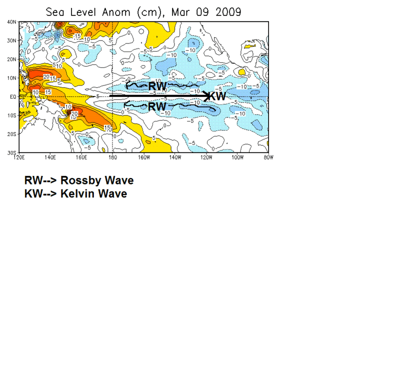
The tropical Pacific, again, has had the big upwelling/subsurface cool pool get eaten away w/ more Kelvin Wave activity. Here is analysis of the latest oceanic features:
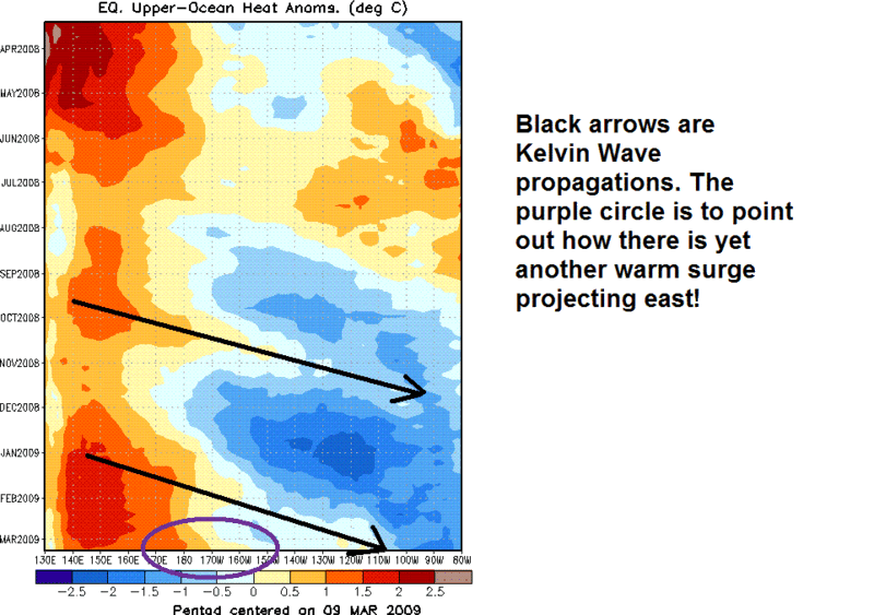
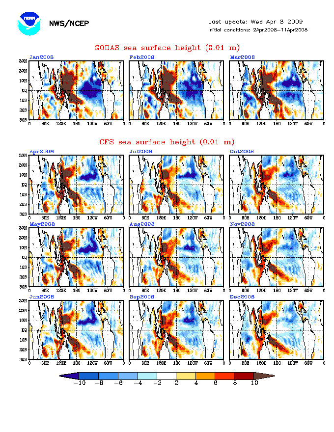
The kelvin wave is pressing east nicely and will probably start eating away at those anomalies in the eastern ENSO regions (mildly). I believe as the warm pool expands, these "ripples" will continue to advance east on a timely manner (with east PAC arrivals around mid May and Mid July). More evidence that this will continue is the wonderful CFS model. Yes I know, it is the CFS, but it is guidance and something we should have a glance at. The current run suggests a rapid advancement eastward of the +SSH anomalies. I thought I would show last year's graphic, which clearly did not do this and held on to the big warm pool through the warm season:

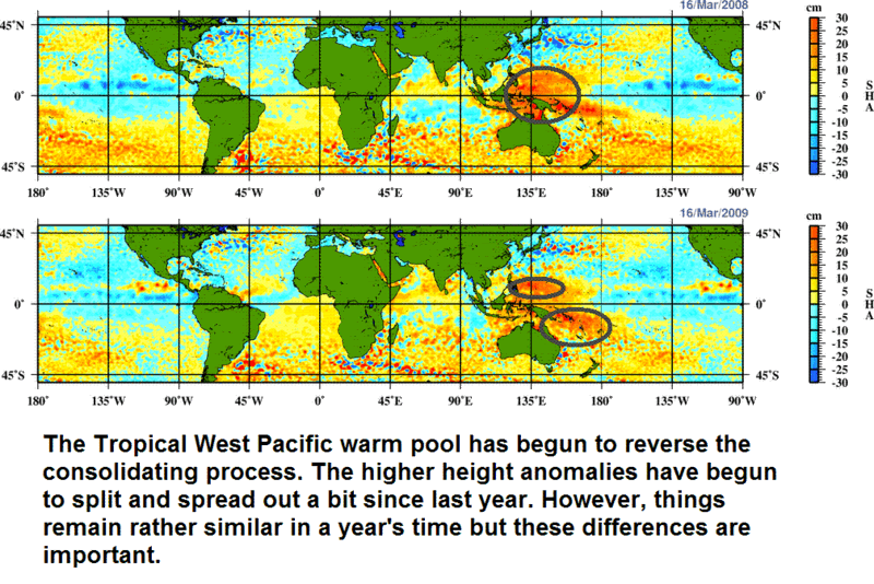
Finally, as you might have noticed from the first set of images, the warm pool is not as strong as last year when we had a strong La Niña forcing heights up west of the DL. The pool was consolidated, strong and not ready to slosh back (in hindsight). Well, there are some differences a year later which argue that the "kingdom" is collapsing somewhat...slowly but surely-->
Now, it is important to keep in mind that this sloshing is not rapid and that even Kelvin Wave ripples take about 2 months to clear the tropical Pacific. So, we don't want to make the mistake of rushing the process. Given the pool is breaking up and expanding somewhat and there are signs of continued "rippling" through the warm season, it is very possible that we continue to warm the SST over the DL and possibly east of that. The warming would obviously start from west to east in this case.
Assessment of Important Currents
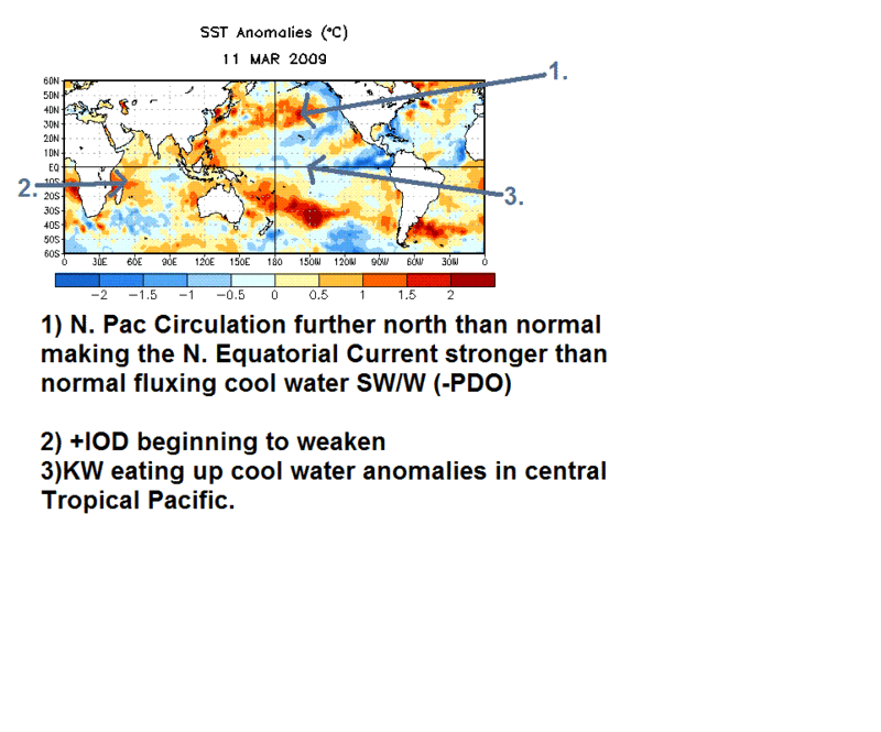
The -PDO is going strong and this has put the North Pacific Circulation further north than normal, strengthening the cold California flux southward/southwestward towards Hawaii and strengthening the North Equatorial current too (notice the warm anomalies off Mexico). The IOD has been solidly positive for a while now w/ the persistent La Niña/like conditions but the western Indian Ocean has really begun to warm up. There are still strong +h85 wind anomalies across the equatorial Indian Ocean banging into that warm pool, all of which are +IOD-like, but the recent warming off Africa may be a clue that things are trying to change. This could further weaken the warm pool and help advance it east some.
The -PDO circulation is quite pronounce and I think it will persist anomalously so through June at least w/ a modification thereafter. If a sloshing back east of the warm water indeed does occur this summer/autumn, that may be the mechanism to choke the cold California flux and perhaps break down the circulation a bit in the N. PAC (along w/ changing atmospheric winds). So, basically what I am trying to say is, you won't see clues from the North Pacific for an ENSO change....if anything it will help sustain the cold phase more and could be a reason El Niño fails to develop. So the question then becomes, given that our currents are not only stable but much stronger than normal...will the currents keep El Niño from forming or will they just help keep it on the weaker side? I will say that if El Niño does develop, it will likely be west-based and weaker given what I am seeing w/ the currents and SSH.
The QBO
Last but certainly not least is everybody's favorite index...the QBO! There are several posters on here who find this index to be useful, including myself, but there are also several who remain skeptical of its importance (and understandably so!). If you want to read my thoughts on the QBO, simply do a thread/post search and you will see I have information on the QBO along w/ the Brewer Dobson Circulation posted...all of which are very important. The QBO affects horizontal and vertical circulations, mean subtropical/tropical temperature anomalies, ozone distribution/flux, tropopause heights, convective anomalies and the cold season's PV. I believe that the QBO also affects ENSO (along w/ mean forcing and MJO) big time but you will not find a simple correlation...and many know this just by staring at the numbers all day and seeing no connection. Therefore, there remains a controversy on how it affects ENSO and what the relationship is exactly.
Well, this year, the QBO will be a factor in determining ENSO state, among many things. I always factor the QBO in, but sometimes its effects are dwarfed by something else. But, if you want to see how the QBO has been doing its dirty work, just compare this past winter's storm frequency in the mid latitudes and MJO frequency w/ last year's and it should give you a clue.
2007 2.61 2.43 1.24 -5.18 -14.07 -21.34 -24.93 -27.41 -28.14 -29.05 -27.61 -19.48
2008 -12.43 -4.70 2.19 6.43 11.53 13.45 13.27 11.63 11.60 11.05 9.13 10.46
2009 10.71 12.33
http://www.bom.gov.au/bmrc/clfor/cfstaff/m...d.2007.12.1.gif
http://www.bom.gov.au/bmrc/clfor/cfstaff/m....Last90days.gif
Once again, don't make linear correlations b/c it is not always going to work but I just wanted to show you how the QBO has been a factor in these particular winters. Also notice we had the driest Jan/Feb on record in the CONUS and the storm frequency is NOTHING like last year's frequency which has a lot to do w/ the Brewer Dobson Circulation. You won't see a clear example like the last two winters and this is because we have been in a prolonged solar minimum (you can see the QBO relationship a little better at the min/max). The prolonged minimum is also one of the reasons why the +QBO phase has decided to stick around (similar to 85-86). There are no real signs of cycle 24 coming to life soon, despite the recent high latitude plage (didn't materialize into a spot).
Anyway, I evaluated empirical information like zonal temperatures/wind and statistical data (analogs) and I believe the switch to a -QBO will happen around July w/ a low positive number/near neutral in June (making this a 16 month positive phase). I could be very wrong and it is possible it switches sooner but right now I am sticking to this solution. After March's data, I will update this forecast for sure! The zonal wind so far for March indicates the westerly shear zone is not quite narrow enough to be destroyed and is actually quite thick (20mb-100mb). Considering downward propagation averages around 1km/month, I think this would keep us at the expected date when I predict a switch over.
Why does it freakin matter? It will cause a regime shift across much of the tropical Pacific and from there would have a domino effect on the pattern and potentially ENSO. The first major change will be a higher than normal tropopause height, i.e. cooler than normal upper troposphere (due to thermal wind) and this will help aid in convection (perhaps rejuvenating the MJO a little bit and overall static stability/forcing). As w/ any stratospheric oscillation, effects from the bottom and the top all affect features in this layer. As westerly momentum is lost (shear zone becomes sufficiently narrow) in the downward shear stress, easterly momentum is being added from upwelling equatorial gravity waves, in particular rossby waves and they will be able to break free. I believe this process has an important impact on ENSO by affecting tropical forcing and tropospheric wind patterns.
The QBO would support the development of a warm event, IMO, during the summer and in particular maybe August.
Most of the above information was posted by a gentleman by the name HM. He posts regularly on Meteorological boards and has taught me everything I know.
 idiot
idiot