Navigation
Install the app
How to install the app on iOS
Follow along with the video below to see how to install our site as a web app on your home screen.

Note: This feature currently requires accessing the site using the built-in Safari browser.
More options
You are using an out of date browser. It may not display this or other websites correctly.
You should upgrade or use an alternative browser.
You should upgrade or use an alternative browser.
Ojai Earthquake
- Thread starter okfine
- Start date

5.1 earthquake 4 miles SE of Ojai. Most likely centered off the SR150 (Sulphur Mountain area) near Santa Paula. I felt it in Montecito. Nice jolt and it's raining. Woo hoo!
Yeah, my kid keeps sending updates from Van Nuys... "Don't worry dad, we're okay... just a 5.1 in Ojai and we're on the 4th floor." She's a gas...
So apparently it rattled the San Fernando Valley as well.
I will party like it is 1999 when California floods or gets leveled.
People who make comments like this are just ignorant... no, I take that back... they're fucking ignorant.

- Moderator
- #8
5.1 earthquake 4 miles SE of Ojai. Most likely centered off the SR150 (Sulphur Mountain area) near Santa Paula. I felt it in Montecito. Nice jolt and it's raining. Woo hoo!
Glad I got out of there on Friday. I was in Santa Barbara for work.
Are we expected to recognize "Ojai"? Californians are so self centered.
okfine
Diamond Member
- Thread starter
- Banned
- #10
As always, Lucy Jones said they're collecting data. News says it was felt in Riverside.Yeah, my kid keeps sending updates from Van Nuys... "Don't worry dad, we're okay... just a 5.1 in Ojai and we're on the 4th floor." She's a gas...
So apparently it rattled the San Fernando Valley as well.
As always, Lucy Jones said they're collecting data. News says it was felt in Riverside.
Lucy Jones. I remember when she was young! LOL
Glad I got out of there on Friday. I was in Santa Barbara for work.
Only a hurricane and an earthquake? Here's one for the road:
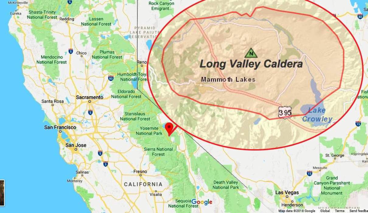
In California, there is concern about the Long Valley Caldera showing signs there could be a volcano coming.
The 16 x 32 km (20 x 10 mi) Long Valley caldera east of the central Sierra Nevada Range formed as a result of the voluminous Bishop Tuff eruption (considered a "supereruption") about 760,000 years ago.
Summary
Resurgent doming in the central part of the caldera occurred shortly after the caldera-forming eruption. During early resurgent doming, the caldera was filled with a large lake that left lake-shore traces (strandlines) on the caldera walls and the resurgent dome peninsula; the lake eventually drained through the Owens River Gorge.Along the caldera's ring fault, Mammoth Knolls is the youngest eruption about 100,000 years ago. In the topographic basin, Cone 2652 in West Moat is about 33,000 years old and dacite lavas in NW Moat are 40,000-27,000 years old. The mafic chain along the west rim is 16,000 to 17,000 years old. The caldera remains thermally active, with many hot springs and fumaroles, and has had significant deformation, seismicity, and other unrest in recent years. A robust geothermal system inside the caldera fuels the Casa Diablo power plant, which generates enough power for 40,000 homes.
The late-Pleistocene to Holocene Mono-Inyo Craters, which cut the northwest topographic rim of the caldera, along with Mammoth Mountain, on the southwest topographic rim, is west of the structural caldera and are chemically and tectonically distinct from the Long Valley magmatic system. The most recent activity in the area was about 300 years ago in Mono Lake. Both Long Valley Caldera and Mammoth Mountain have experienced episodes of heightened unrest over the last few decades (earthquakes, ground uplift, and/or volcanic gas emissions). As a result, the USGS manages a dense array of field sensors providing the real-time data needed to track unrest and assess hazards.
link
JULY 5, 2023
The Mystery of the Noon Booms Part 2
linkJUNE 21, 2023
Bubble trouble? Tracking changing hydrothermal features in Long Valley's Hot Creek
linkMAY 24, 2023
What makes Long Valley's resurgent dome reach for the skies?
View AllQuick Facts
Location: California, Mono CountyLatitude: 37.7° N
Longitude: 118.87° W
Elevation: 2,600 (m) 8,530 (f)
Volcano type: caldera
Composition: basalt to rhyolite
Most recent eruption: 16,000-17,000 years ago
Nearby towns: Mammoth Lakes
Threat Potential: Very High
If it does blow, I hope it's a small eruption. Nobody ever knows whether resurgent domes will become an eruption or go back quietly into the sunset.

Even though I don't think it's much of a panic at this time, here's a history of three very high-potential volcanic regions, three of the high potential and two moderate regions. Magma intrusion beneath Long Valley Caldera confirmed by Science - Strange Sounds

Last edited:
Concerned American
Diamond Member
Five point is hardly worth mentioning. I'd love to see an 8 pt. centered in downtown LA.5.1 earthquake 4 miles SE of Ojai. Most likely centered off the SR150 (Sulphur Mountain area) near Santa Paula. I felt it in Montecito. Nice jolt and it's raining. Woo hoo!
- Moderator
- #16
Are we expected to recognize "Ojai"? Californians are so self centered.
It's a pretty well known destination. Maybe you should get out of your 100 person town more.
- Oct 24, 2012
- 1,902
- 1,793
- 1,930
Five point is hardly worth mentioning. I'd love to see an 8 pt. centered in downtown LA.
Morbid.
Are we expected to recognize "Ojai"? Californians are so self centered.
You never watched The Bionic Woman?
lennypartiv
Diamond Member
- Jul 16, 2019
- 25,758
- 19,726
- 2,320
A hurricane and an earthquake and God didn't take out any liberal Democrat voters? What a waste of two natural disasters
Similar threads
- Replies
- 431
- Views
- 7K
- Replies
- 35
- Views
- 2K
Latest Discussions
- Replies
- 77
- Views
- 266
- Replies
- 58
- Views
- 420
- Replies
- 33
- Views
- 231
- Replies
- 17
- Views
- 142
Forum List
-
-
-
-
-
Political Satire 8058
-
-
-
-
-
-
-
-
-
-
-
-
-
-
-
-
-
-
-
ObamaCare 781
-
-
-
-
-
-
-
-
-
-
-
Member Usernotes 469
-
-
-
-
-
-
-
-
-
-