IDQP0005
Australian Government Bureau of Meteorology
Queensland
Tropical Cyclone Warning Centre
Media: Transmitters serving the area between Cape Melville to Sarina are
requested to USE the Standard Emergency Warning Signal before broadcasting the
following warning.
TOP PRIORITY
TROPICAL CYCLONE ADVICE NUMBER 13
Issued by the Bureau of Meteorology, Brisbane
Issued at 11:12am EST on Wednesday the 2nd of February 2011
A Cyclone WARNING is current for coastal and island communities from Cape
Melville to Sarina, extending inland to Croydon and Richmond.
A Cyclone WATCH is current for the remaining inland parts west to the Northern
Territory border and north of Winton.
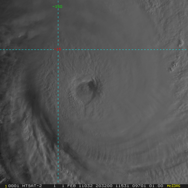
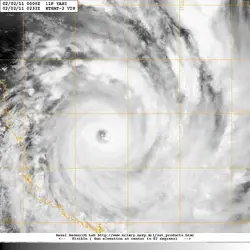
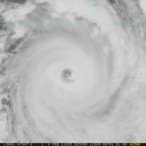
At 10:00 am EST Severe Tropical Cyclone Yasi, Category 5 was estimated to be 445
kilometres east of Cairns and 455 kilometres northeast of Townsville and moving
west southwest at 30 kilometres per hour.
SEVERE TC YASI IS A LARGE AND VERY POWERFUL TROPICAL CYCLONE AND POSES AN
EXTREMELY SERIOUS THREAT TO LIFE AND PROPERTY WITHIN THE WARNING AREA,
ESPECIALLY BETWEEN CAIRNS AND TOWNSVILLE.
THIS IMPACT IS LIKELY TO BE MORE LIFE THREATENING THAN ANY EXPERIENCED DURING
RECENT GENERATIONS.
TC Yasi, CATEGORY 5, will continue to move in a west-southwesterly direction
during the day. The cyclone is expected to cross the coast in the Innisfail area
at about midnight.
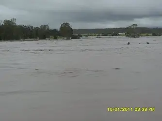
Coastal residents within the warning area, and particularly between Cairns and
Ayr are specifically warned of an EXTREMELY DANGEROUS SEA LEVEL RISE [i.e. storm
tide] as the cyclone approaches, crosses the coast and moves inland. The sea is
likely to steadily rise up to a level which will be VERY DANGEROUSLY above the
normal tide, with EXTREMELY DAMAGING WAVES, STRONG CURRENTS and FLOODING of
low-lying areas extending some way inland. People living in areas likely to be
affected by this flooding should take measures to protect their property as much
as possible, and be prepared to follow instructions regarding evacuation of the
area if advised to do so by authorities.
DAMAGING WINDS with gusts to 90 km/hr that are currently developing on coastal
islands, are forecast to develop about the coast by late morning and about the
tropical interior overnight.
Between Cape Tribulation and Ingham these winds will become DESTRUCTIVE with
gusts in excess of 125km/hr during the afternoon and early evening and VERY
DESTRUCTIVE with gusts up to 300 km/hr between Cairns and Ingham during the
evening as the cyclone approaches and crosses the coast. These VERY DESTRUCTIVE
winds can also occur on the seaward side of hills to the north of the cyclone
and are also forecast to reach the Atherton Tablelands.
Winds are forecast to ease about the east coast during Thursday morning as the
cyclone moves inland.
FLOODING RAINS will develop from Cooktown to Sarina during the afternoon and
then extend inland overnight.
People between Cape Melville and Sarina, extending inland to Croydon and
Richmond should complete preparations quickly and be prepared to shelter in a
safe place.
- Boats and outside property should be secured.
- For cyclone preparedness and safety advice, visit Queensland's Disaster
Management Services website [
www.disaster.qld.gov.au]
- For emergency assistance call the Queensland State Emergency Service [SES] on
132 500 [for assistance with storm damage, rising flood water, fallen trees on
buildings or roof damage].
People about the remaining inland parts west to the Northern Territory border
and north of Winton should consider what action they will need to take if the
cyclone threat increases.
- Information is available from your local government
- For cyclone preparedness and safety advice, visit Queensland's Disaster
Management Services website [
www.disaster.qld.gov.au]
- For emergency assistance call the Queensland State Emergency Service [SES] on
132 500 [for assistance with storm damage, rising flood water, fallen trees on
buildings or roof damage].
Details of Severe Tropical Cyclone Yasi at 10:00 am EST:
.Centre located near...... 16.4 degrees South 149.9 degrees East
.Location accuracy........ within 30 kilometres
.Recent movement.......... towards the west southwest at 30 kilometres per hour
.Wind gusts near centre... 295 kilometres per hour
.Severity category........ 5
.Central pressure......... 922 hectoPascals
Please ensure that neighbours have heard and understood this message,
particularly new arrivals or those who may not fully understand English.
The next advice will be issued by 2:00 pm EST Wednesday 02 February.
This warning is also available through TV and Radio Broadcasts; the Bureau's
website at
Bureau of Meteorology - Home Page or call 1300 659 212. The Bureau and the State
Emergency Service would appreciate this warning being broadcast regularly.