La Niña – What It’s Going to Do to the 2017 Winter

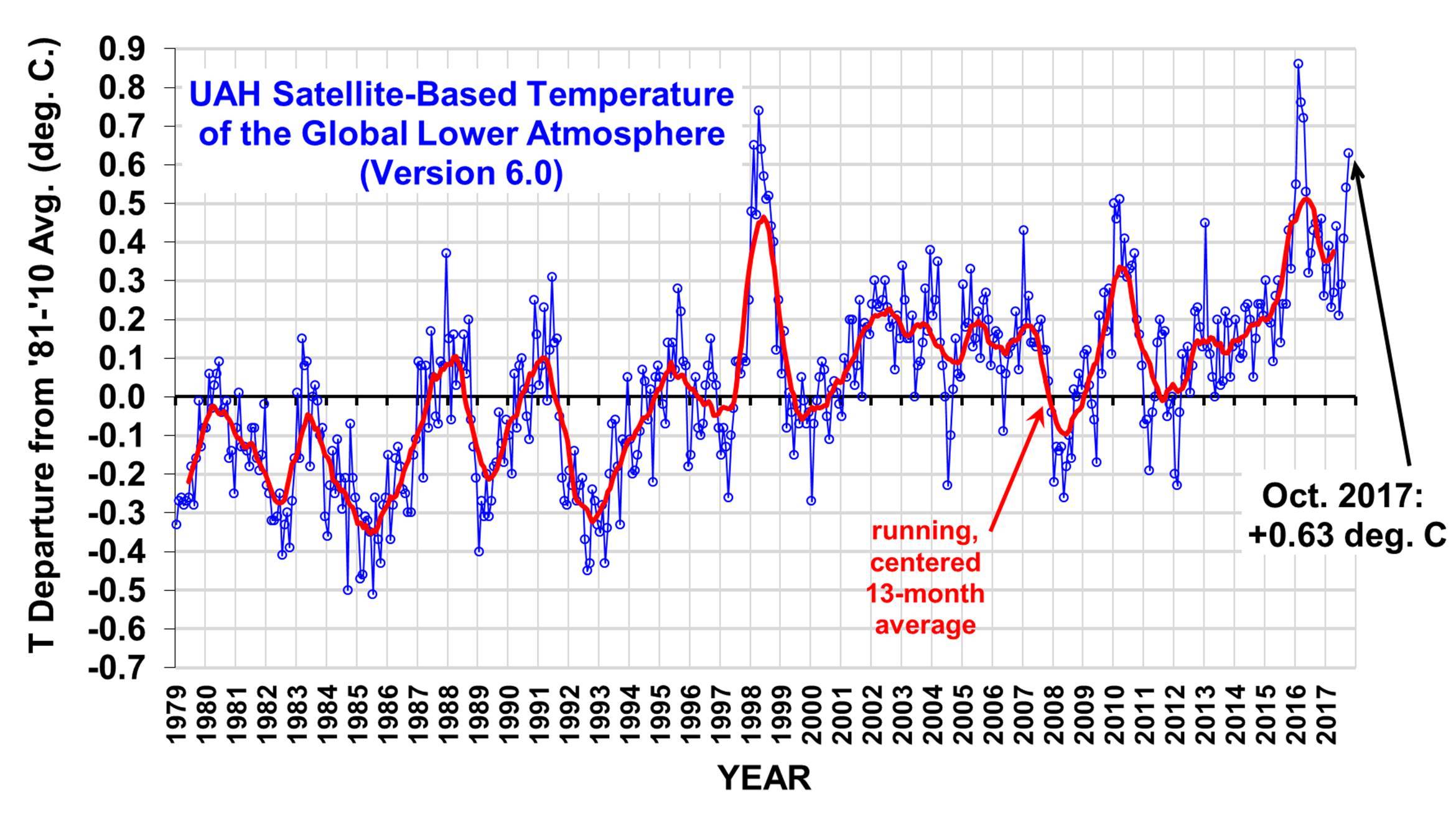
And this is what is coming...
nino1.png
 
This just in, winter weather on tap for the winter season....That is all...
You forgot that the fall of 3 deg C in the ocean surface temps will cause a 3-5 deg C drop in ambient air temps globally.. Get out your fuzzy ball warmers...
As long as my crack doesn't crack from dry skin it's not a bad winter...
You really shouldn't leave it exposed...
Kinda hard when you bend over a lot..
 
You forgot that the fall of 3 deg C in the ocean surface temps will cause a 3-5 deg C drop in ambient air temps globally.. Get out your fuzzy ball warmers...

So, everyone, prepare for warming. After all, Billy has predicted cooling, and Billy has an unbroken perfect record here of predicting the opposite of reality. He also sulks and cries when you point that out, which makes it even funnier.

Back in reality, pretty much everyone is predicting a brief moderate La Nina, returning to neutral conditions next spring.

figure07.gif
 
Last edited:
tpacv2.png


Nowhere to go but Colder..

Hey OLD CROCK... The empirically observed data say's your FULL OF CRAP!
Now Silly Billy, I posted repeatedly that a weak La Nina is in the forecast.

Climate Prediction Center: ENSO Diagnostic Discussion

ENSO Alert System Status: La Niña Advisory


Synopsis: La Niña conditions are predicted to continue (~65-75% chance) at least through the Northern Hemisphere winter 2017-18.

During October, weak La Niña conditions emerged as reflected by below-average sea surface temperatures (SSTs) across most of the central and eastern equatorial Pacific Ocean [Fig. 1]. The weekly Niño indices were variable during the month, with values near -0.5° C during the past week in the Niño-3.4 and Niño-3 regions [Fig. 2]. Sub-surface temperatures remained below average during October [Fig. 3], reflecting the anomalously shallow depth of the thermocline across the central and eastern Pacific [Fig. 4]. Also, convection was suppressed near the International Date Line and slightly enhanced over parts of the Maritime Continent and the Philippines [Fig. 5]. Over the equatorial Pacific Ocean, low-level trade winds were mainly near average, but the upper-level winds were strongly anomalously westerly and the Southern Oscillation Index was positive. Overall, the ocean and atmosphere system reflects the onset of La Niña conditions.

For the remainder of the Northern Hemisphere fall and winter 2017-18, a weak La Niña is favored in the model averages of the IRI/CPC plume [Fig. 6] and also in the North American Multi-Model Ensemble (NMME) [Fig. 7]. The consensus of forecasters is for the event to continue through approximately February-April 2018. In summary, La Niña conditions are predicted to continue (~65-75% chance) at least through the Northern Hemisphere winter (click CPC/IRI consensus forecast for the chance of each outcome for each 3-month period).

La Niña is likely to affect temperature and precipitation across the United States during the upcoming months (the 3-month seasonal temperature and precipitation outlooks will be updated on Thursday November 16th). The outlooks generally favor above-average temperatures and below-median precipitation across the southern tier of the United States, and below-average temperatures and above-median precipitation across the northern tier of the United States.

And I also posted this;
UAH_LT_1979_thru_October_2017_v6-1.jpg


http://www.drroyspencer.com/wp-content/uploads/UAH_LT_1979_thru_October_2017_v6-1.jpg

So we have a weak La Nina in the making, but we see that spike in temperatures. That should not be there even in a neutral ENSO. Going to be interesting to see what November brings.
 

Forum List

Back
Top