As clearly shown in the classic radiative forcing diagram, Effective Radiative Forcing factors are "based on energy balance constraints, observational evidence from satellite retrievals and climate model-based evidence" and the source of each entry is clearly noted in the text. Your blanket rejection of all climate models is simply another clear indicator that you are not what you claim to be.Link please.
Navigation
Install the app
How to install the app on iOS
Follow along with the video below to see how to install our site as a web app on your home screen.
Note: This feature may not be available in some browsers.
More options
Style variation
You are using an out of date browser. It may not display this or other websites correctly.
You should upgrade or use an alternative browser.
You should upgrade or use an alternative browser.
CO2 Has Almost No Effect on Global Temperature, Says Leading Climate Scientist
- Thread starter bripat9643
- Start date
Here is what a physics group has to say about the modeling used by the IPCC.
"The principal behind these grids is simple: since modelling the global climate is far too complex, researchers divide the Earth and the atmosphere into grid boxes, cubes with edges that are usually 100 kilometres long. In these boxes, the biological, chemical and physical processes that affect the climate can be modelled using supercomputers. But the fact that a length of 100 kilometres is much too crude to take important processes directly into account—like the small eddies, only a few kilometres in size, in the Gulf Stream and other ocean currents that lead to increased heat and moisture exchange between the sea and the atmosphere. Many climate models are unable to accurately depict the course of the Gulf Stream, which originates in the Gulf of Mexico and travels northwards along the Florida coast before veering eastwards towards Europe. In a lot of models the current moves much too far to the north due the small eddies not being included."
Sorry Crick but even the current unstructured modeling is failing badly..
Source: New climate model for the IPCC
These people seem to disagree:
What Are Climate Models and How Accurate Are They?
How past climate data improves our understanding of climate change and helps predict its impacts.

Study Confirms Climate Models are Getting Future Warming Projections Right - NASA Science
A new evaluation of global climate models used to project Earth's future global average surface temperature finds that most have been quite accurate.
 climate.nasa.gov

UCBerkeley-MIT-NASA study reports on the accuracy of climate models
Climate skeptics have long raised doubts about the accuracy of computer models that predict global warming, but it turns out that most of the early climate models were spot-on, according to a look-back by climate scientists at the University of California, Berkeley, Massachusetts Institute of...
How climate models got so accurate they earned a Nobel Prize
Climate predictions were treated with heavy skepticism just 30 years ago, but they've become our main window into how global warming works.

How reliable are climate models?
<p>While there are uncertainties with climate models, they successfully reproduce the past and have made predictions that have been subsequently confirmed by observations.</p>
skepticalscience.com
bripat9643
Diamond Member
- Apr 1, 2011
- 170,170
- 47,448
- 2,180
- Thread starter
- #443
These are nothing more than guesses, and they are all wildly wrongYou really ought to do at least a little research before doubling down on somethingi that's been challenged. This took about ten seconds.
From Continental drift - Wikipedia
Early history
See also: Early modern Netherlandish cartography and geography
Abraham Ortelius by Peter Paul Rubens, 1633
Abraham Ortelius (Ortelius 1596),[5] Theodor Christoph Lilienthal (1756),[6] Alexander von Humboldt (1801 and 1845),[6] Antonio Snider-Pellegrini (Snider-Pellegrini 1858), and others had noted earlier that the shapes of continents on opposite sides of the Atlantic Ocean (most notably, Africa and South America) seem to fit together.[7] W. J. Kious described Ortelius' thoughts in this way:[8]
In 1889, Alfred Russel Wallace remarked, "It was formerly a very general belief, even amongst geologists, that the great features of the earth's surface, no less than the smaller ones, were subject to continual mutations, and that during the course of known geological time the continents and great oceans had, again and again, changed places with each other."[9] He quotes Charles Lyell as saying, "Continents, therefore, although permanent for whole geological epochs, shift their positions entirely in the course of ages."[10] and claims that the first to throw doubt on this was James Dwight Dana in 1849.
Antonio Snider-Pellegrini's Illustration of the closed and opened Atlantic Ocean (1858)[11]
In his Manual of Geology (1863), Dana wrote, "The continents and oceans had their general outline or form defined in earliest time. This has been proved with regard to North America from the position and distribution of the first beds of the Lower Silurian, – those of the Potsdam epoch. The facts indicate that the continent of North America had its surface near tide-level, part above and part below it (p.196); and this will probably be proved to be the condition in Primordial time of the other continents also. And, if the outlines of the continents were marked out, it follows that the outlines of the oceans were no less so".[12] Dana was enormously influential in America—his Manual of Mineralogy is still in print in revised form—and the theory became known as the Permanence theory.[13]
This appeared to be confirmed by the exploration of the deep sea beds conducted by the Challenger expedition, 1872–1876, which showed that contrary to expectation, land debris brought down by rivers to the ocean is deposited comparatively close to the shore on what is now known as the continental shelf. This suggested that the oceans were a permanent feature of the Earth's surface, rather than them having "changed places" with the continents.[9]
Eduard Suess had proposed a supercontinent Gondwana in 1885[14] and the Tethys Ocean in 1893,[15] assuming a land-bridge between the present continents submerged in the form of a geosyncline, and John Perry had written an 1895 paper proposing that the earth's interior was fluid, and disagreeing with Lord Kelvin on the age of the earth.[16]

jc456
Diamond Member
- Dec 18, 2013
- 160,665
- 40,210
- 2,180
he'll answer institution!!!!! hahahahahahahahahahahahaPersonal attack... and not one attempt to address the science presented. How original...
Tell me what removing 71-75% of your imaginary heat from LWIR does to your global circulation modeling? Does it remove the 10 times over estimation of heat collection in our atmosphere? Suddenly your god is being questioned with real science.
Come on butt boi, pony up some actual science.
jc456
Diamond Member
- Dec 18, 2013
- 160,665
- 40,210
- 2,180
what is the evidence of catastrophe?Study Confirms Climate Models are Getting Future Warming Projections Right – Climate Change: Vital Signs of the Planet
A new evaluation of global climate models used to project Earth's future global average surface temperature finds that most have been quite accurate.climate.nasa.gov
What the **** are you talking about? You claimed that no geologists had thought about plate tectonics prior to Wegener but this article shows that's simply not true. Geologists had been thinking about this specific issue for many years before him.These are nothing more than guesses, and they are all wildly wrong
Billy_Bob
Diamond Member
Too Funny.... You cite CIRCULAR BACK SLAPPING AS PROOF..... Most of the boys at NASA and NOAA are people who post at skeptical shit science... You are using the same idiots that can't get it right as proof that they can.. Do you see how stupid this is as an argument?These people seem to disagree:
What Are Climate Models and How Accurate Are They?
How past climate data improves our understanding of climate change and helps predict its impacts.news.climate.columbia.edu
Study Confirms Climate Models are Getting Future Warming Projections Right - NASA Science
A new evaluation of global climate models used to project Earth's future global average surface temperature finds that most have been quite accurate.
UCBerkeley-MIT-NASA study reports on the accuracy of climate models
Climate skeptics have long raised doubts about the accuracy of computer models that predict global warming, but it turns out that most of the early climate models were spot-on, according to a look-back by climate scientists at the University of California, Berkeley, Massachusetts Institute of...climate.mit.edu
How climate models got so accurate they earned a Nobel Prize
Climate predictions were treated with heavy skepticism just 30 years ago, but they've become our main window into how global warming works.www.nationalgeographic.com
How reliable are climate models?
<p>While there are uncertainties with climate models, they successfully reproduce the past and have made predictions that have been subsequently confirmed by observations.</p>skepticalscience.com
Billy_Bob
Diamond Member
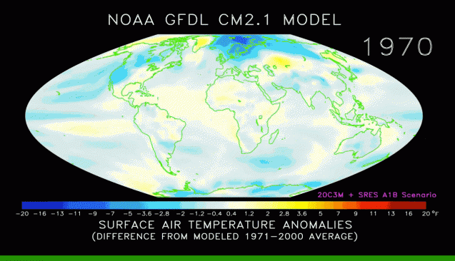
Ah yes... Figured you would bring this up... It's derived from the IPCC MODEL... You people just do not give up in circular reasoning...As clearly shown in the classic radiative forcing diagram, Effective Radiative Forcing factors are "based on energy balance constraints, observational evidence from satellite retrievals and climate model-based evidence" and the source of each entry is clearly noted in the text. Your blanket rejection of all climate models is simply another clear indicator that you are not what you claim to be.
View attachment 746751
WHAT is derived from WHAT model?Ah yes... Figured you would bring this up... It's derived from the IPCC MODEL... You people just do not give up in circular reasoning...
You seem to have forgotten, the IPCC does no research. The IPCC neither develops nor runs general climate models.
Billy_Bob
Diamond Member
And yet when these GCM (Global Circulation Models) are tested, they all fail. Dr Roy Spencer took 73 of the top GCM's, primed them with the exact same data, up through 1979, and then let them run. His point was to test them empirically against the real world.

Guess what they all do Crick... They FAIL WITHOUT EXCEPTION.
Guess what they all do Crick... They FAIL WITHOUT EXCEPTION.
Billy_Bob
Diamond Member
Your graphing of "were doing this right"... You are so gullible. Where do you think they get thier "potential forcings" from? IT sure as hell is not empirical evidence.WHAT is derived from WHAT model?
You seem to have forgotten, the IPCC does no research. The IPCC neither develops nor runs general climate models.
Whatever I may be, it includes being able to write intelligible sentences.Your graphing of "were doing this right"... You are so gullible.
Again, WHAT is derived from WHAT model?Whatever I may be, it includes being able to write intelligible sentences.
Good ******* god are you stupid. Spencer's bullshit LIES here were debunked about two days after he published them.And yet when these GCM (Global Circulation Models) are tested, they all fail. Dr Roy Spencer took 73 of the top GCM's, primed them with the exact same data, up through 1979, and then let them run. His point was to test them empirically against the real world.
View attachment 746786
Guess what they all do Crick... They FAIL WITHOUT EXCEPTION.
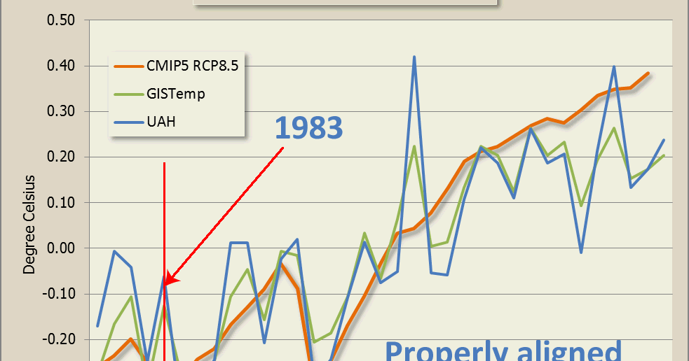
Roy Spencer's latest deceit and deception
Global warming & climate change. Eavesdropping on climate science deniers, their weird pseudo-science and crazy conspiracy theories.
No one with a doctorate in atmospheric physics would have fallen for this. Get what I mean?
bripat9643
Diamond Member
- Apr 1, 2011
- 170,170
- 47,448
- 2,180
- Thread starter
- #455
That's wrong. They had a lot of theories about why the earth looked the way it did, but plate tectonics wasn't one of them. Even after Wegener published his theory of continental drift, he didn't postulate the theory of plate tectonics. That still doesn't get Dagosa out of his predicament of claiming the institutions are never wrongWhat the **** are you talking about? You claimed that no geologists had thought about plate tectonics prior to Wegener but this article shows that's simply not true. Geologists had been thinking about this specific issue for many years before him.
bripat9643
Diamond Member
- Apr 1, 2011
- 170,170
- 47,448
- 2,180
- Thread starter
- #456
You mean it took them two ways to invent a bullshit argument to spin them awayGood ******* god are you stupid. Spencer's bullshit LIES here were debunked about two days after he published them.
Roy Spencer's latest deceit and deception
Global warming & climate change. Eavesdropping on climate science deniers, their weird pseudo-science and crazy conspiracy theories.blog.hotwhopper.com
No one with a doctorate in atmospheric physics would have fallen for this. Get what I mean?
This is what you said
The Wikipedia article says you are wrong.
Abraham Ortelius (Ortelius 1596),[5] Theodor Christoph Lilienthal (1756),[6] Alexander von Humboldt (1801 and 1845),[6] Antonio Snider-Pellegrini (Snider-Pellegrini 1858), and others had noted earlier that the shapes of continents on opposite sides of the Atlantic Ocean (most notably, Africa and South America) seem to fit together.[7] W. J. Kious described Ortelius' thoughts in this way:[8]

Antonio Snider-Pellegrini's Illustration of the closed and opened Atlantic Ocean (1858)[11]
In his Manual of Geology (1863), Dana wrote, "The continents and oceans had their general outline or form defined in earliest time. This has been proved with regard to North America from the position and distribution of the first beds of the Lower Silurian, – those of the Potsdam epoch. The facts indicate that the continent of North America had its surface near tide-level, part above and part below it (p.196); and this will probably be proved to be the condition in Primordial time of the other continents also. And, if the outlines of the continents were marked out, it follows that the outlines of the oceans were no less so".[12] Dana was enormously influential in America—his Manual of Mineralogy is still in print in revised form—and the theory became known as the Permanence theory.[13]
This appeared to be confirmed by the exploration of the deep sea beds conducted by the Challenger expedition, 1872–1876, which showed that contrary to expectation, land debris brought down by rivers to the ocean is deposited comparatively close to the shore on what is now known as the continental shelf. This suggested that the oceans were a permanent feature of the Earth's surface, rather than them having "changed places" with the continents.[9]
Eduard Suess had proposed a supercontinent Gondwana in 1885[14] and the Tethys Ocean in 1893,[15] assuming a land-bridge between the present continents submerged in the form of a geosyncline, and John Perry had written an 1895 paper proposing that the earth's interior was fluid, and disagreeing with Lord Kelvin on the age of the earth.[16]
100% believed that because there was no other theory, moron. Wegener published his theory in 1912. What was the theory prior to that, eh moron?
Prior to 1921 geologist didn't believe continents mover over time, you ******* moron. The didn't even discuss such a possibility. Congenital drift and plat tectonics are the same ******* thing
The Wikipedia article says you are wrong.
Abraham Ortelius (Ortelius 1596),[5] Theodor Christoph Lilienthal (1756),[6] Alexander von Humboldt (1801 and 1845),[6] Antonio Snider-Pellegrini (Snider-Pellegrini 1858), and others had noted earlier that the shapes of continents on opposite sides of the Atlantic Ocean (most notably, Africa and South America) seem to fit together.[7] W. J. Kious described Ortelius' thoughts in this way:[8]
In 1889, Alfred Russel Wallace remarked, "It was formerly a very general belief, even amongst geologists, that the great features of the earth's surface, no less than the smaller ones, were subject to continual mutations, and that during the course of known geological time the continents and great oceans had, again and again, changed places with each other."[9] He quotes Charles Lyell as saying, "Continents, therefore, although permanent for whole geological epochs, shift their positions entirely in the course of ages."[10] and claims that the first to throw doubt on this was James Dwight Dana in 1849.Abraham Ortelius in his work Thesaurus Geographicus ... suggested that the Americas were "torn away from Europe and Africa ... by earthquakes and floods" and went on to say: "The vestiges of the rupture reveal themselves if someone brings forward a map of the world and considers carefully the coasts of the three [continents]."

Antonio Snider-Pellegrini's Illustration of the closed and opened Atlantic Ocean (1858)[11]
In his Manual of Geology (1863), Dana wrote, "The continents and oceans had their general outline or form defined in earliest time. This has been proved with regard to North America from the position and distribution of the first beds of the Lower Silurian, – those of the Potsdam epoch. The facts indicate that the continent of North America had its surface near tide-level, part above and part below it (p.196); and this will probably be proved to be the condition in Primordial time of the other continents also. And, if the outlines of the continents were marked out, it follows that the outlines of the oceans were no less so".[12] Dana was enormously influential in America—his Manual of Mineralogy is still in print in revised form—and the theory became known as the Permanence theory.[13]
This appeared to be confirmed by the exploration of the deep sea beds conducted by the Challenger expedition, 1872–1876, which showed that contrary to expectation, land debris brought down by rivers to the ocean is deposited comparatively close to the shore on what is now known as the continental shelf. This suggested that the oceans were a permanent feature of the Earth's surface, rather than them having "changed places" with the continents.[9]
Eduard Suess had proposed a supercontinent Gondwana in 1885[14] and the Tethys Ocean in 1893,[15] assuming a land-bridge between the present continents submerged in the form of a geosyncline, and John Perry had written an 1895 paper proposing that the earth's interior was fluid, and disagreeing with Lord Kelvin on the age of the earth.[16]
Read the Hot Whopper article and try to refute ANY of it. The Spencer graph was so bad that the initial reaction was people thought Spencer and Christy were playing a joke on Anthony Watts.You mean it took them two ways to invent a bullshit argument to spin them away
Toddsterpatriot
Diamond Member
Personal attack... and not one attempt to address the science presented. How original...
Tell me what removing 71-75% of your imaginary heat from LWIR does to your global circulation modeling? Does it remove the 10 times over estimation of heat collection in our atmosphere? Suddenly your god is being questioned with real science.
Come on butt boi, pony up some actual science.
Tell me what removing 71-75% of your imaginary heat from LWIR does to your global circulation modeling?
Nothing is removing 71-75% of LWIR.
jc456
Diamond Member
- Dec 18, 2013
- 160,665
- 40,210
- 2,180
how do they know what they post is accurate?WHAT is derived from WHAT model?
You seem to have forgotten, the IPCC does no research. The IPCC neither develops nor runs general climate models.
Something about - We de facto redistribute the world’s wealth due to climate politics.
Similar threads
- Replies
- 2
- Views
- 112
- Replies
- 8
- Views
- 164
- Replies
- 62
- Views
- 1K
- Replies
- 9
- Views
- 525
New Topics
-

-

-
 Several Women Who Dated Graham Platner Recall ‘Unsettling’ Behavior
- Started by DonGlock26
- Replies: 10
-
 Paul Krugman's Deranged Call to Purge America of MAGA Is Scarier Than You Think
- Started by Doc7505
- Replies: 6
Latest Discussions
-
 Jill Biden falsely claims Hunter Biden only had 1 child, a boy
- Latest: EvilCat Breath
-

-
