Tracking the el nino

Hurricane Patricia Recap: Strongest Landfalling Pacific Hurricane on Record

In addition to its unprecedented 200-mph (320-kph) sustained winds, Hurricane Patricia broke the record for lowest pressure in any hurricane on record. With a minimum central pressure of 880 millibars (25.99 inches of mercury) at the 4 a.m. CDT advisory Oct. 23, Patricia broke the record of 882 millibars set by Wilma in the Atlantic Basin almost exactly 10 years earlier. Around 1 p.m. CDT Oct. 23, the minimum central pressure reached its lowest point, 879 millibars (25.96 inches of mercury).

Data from an Air Force Hurricane Hunter airborne reconnaissance mission late on the night of Oct. 22 provided critical data demonstrating the extreme intensification of Hurricane Patricia in near-real time. A new NOAA reconnaissance aircraft reached the eye of Patricia early on the afternoon of Oct. 23 to gather additional direct measurements of the storm's intensity.

Unprecedented Among Pacific Hurricanes
Hurricane Patricia became the strongest Pacific hurricane on record shortly after midnight CDT early on Oct. 23. Air Force Hurricane Hunters had flown through the eye of Patricia and reported a sea-level pressure of 894 millibars as measured by a dropsonde inside the eye itself. Wind measurements suggested that the pressure measurement was not in the exact center of the eye and was probably not the absolute lowest pressure, prompting NHC to estimate the minimum central pressure at 892 millibars in its special 12:30 a.m. CDT advisory.

Tropical cyclone strength comparisons are typically based on minimum central pressure. At 892 millibars, Patricia shattered the Eastern Pacific basin's previous record of 902 millibars set by Hurricane Linda in 1997.

While a number of typhoons in the western North Pacific have been stronger, Patricia is now by far the strongest hurricane on record in any basin where the term "hurricane" applies to tropical cyclones – namely, the central and eastern North Pacific basins and the North Atlantic basin, which includes the North Atlantic Ocean itself plus the Gulf of Mexico and Caribbean Sea.

So there you have it, flap yap at the people that measure these things.
so I know what was different, Patricia was a Cat 5 that acted like a Cat 3, so, it didn't have the potential of a Cat 4 even though it was classified five. interesting eh?
How much does the ocean warming do to increase the power of storms? And how much more warming can we expect? What will the effect be on future El Nino's? How many times can we dodge the bullet?

Time to really do some serious research, for lives will depend on it. And it is hard to build the infrastructure we need for the future, when we are using our resources to rebuild from weather damage.
 
Silly Billy, how many times in the last nine months have you stated that the El Nino would not develop? How many times have you stated that it was cooling? Nobody with a record of foolishness that you have should be saying anything about anybody else. And Barack Obama is President of the United States of America. Just what the hell have you ever done with your life other than post nonsense on an internet message board?

Awww..... Poor little libtard. You cant even provide basic empirical evidence to support your tripe.. The only silly person is you... And speaking of nonsense, your religious bowing to your god obama shows how totally ignorant of science your are. You probably believe every lie that comes from Obama's mouth..

Does your home alter burn day and night for your god? Your private line to get your talking points still working?
 
I provided the links from NOAA, Japan's meteorlogical service, and the USGS and NASA. You, on the other hand, only refer to your 'group'. And their predictions concerning the present very strong El Nino were spot on, while yours, as anyone can see by reviewing this thread, were only 180 degrees off base.

And the present very strong El Nino has nothing at all to do with President Obama. That you have to spew on that is only an indication of how indefensible your lies have become.
 
More inconvenient facts for the alarmists..

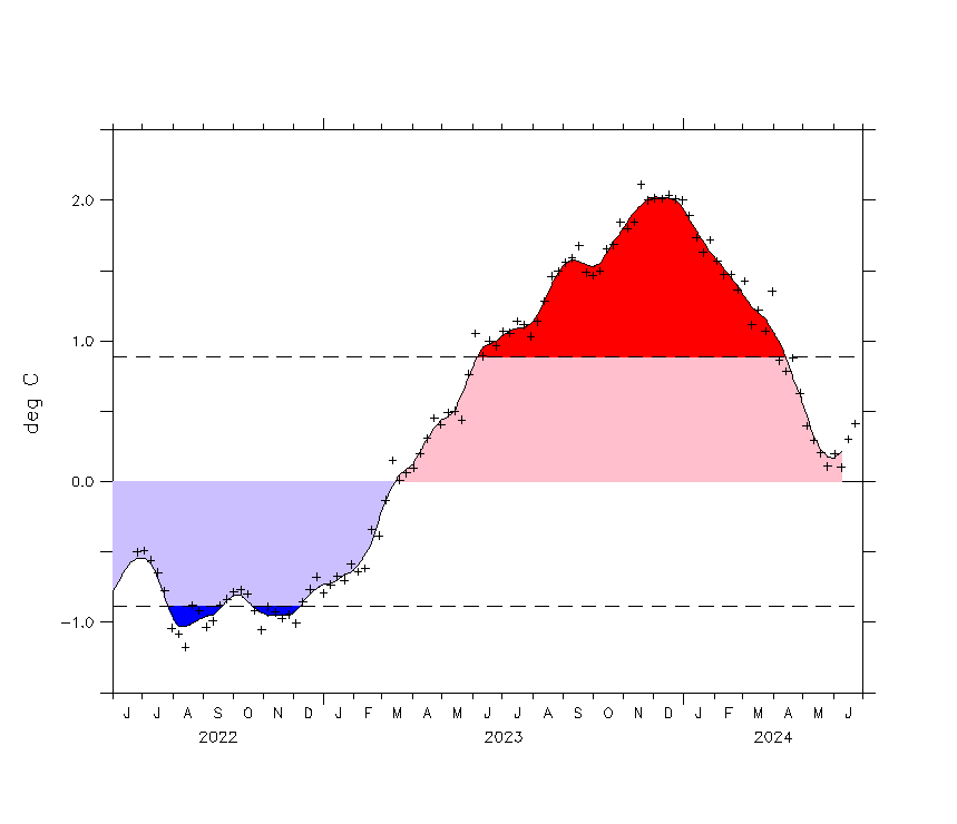
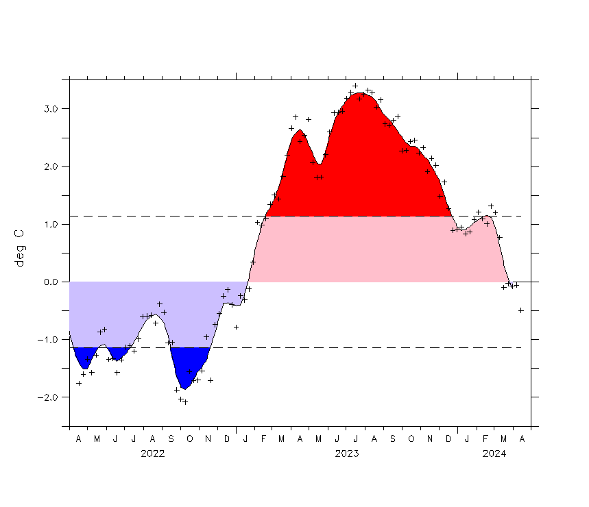
*Region 1-2 has dropped 0.65 deg C this week alone.
nino12_short.gif


*Region three is following suit with a drop of 0.37 deg C
nino3_short.gif


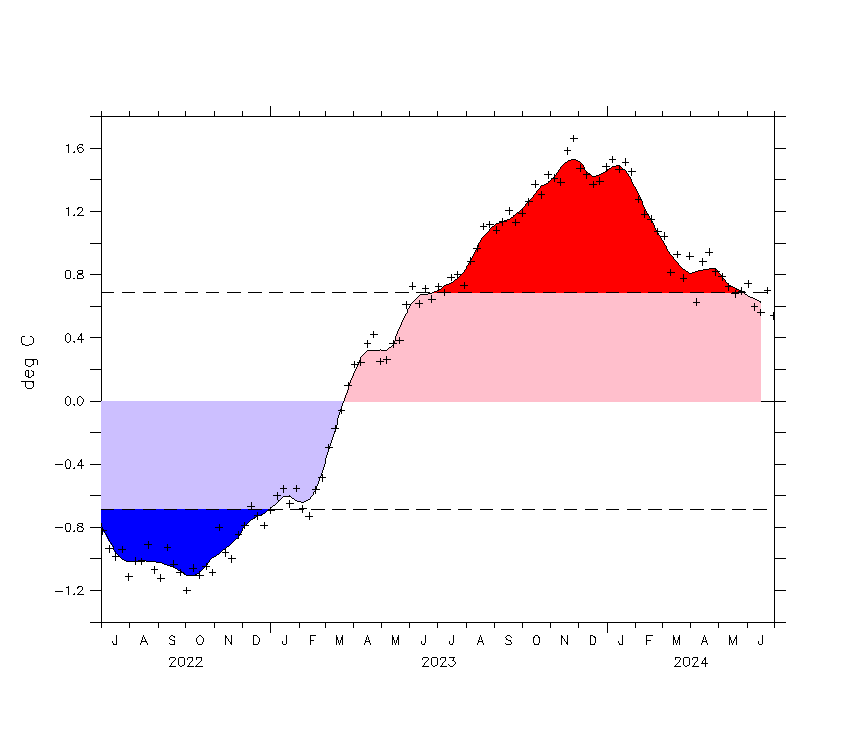
*Region 3-4 is stagnate indicating peak has been reached but the last three days have shown decline of 0.1 deg C.
nino34_short.gif


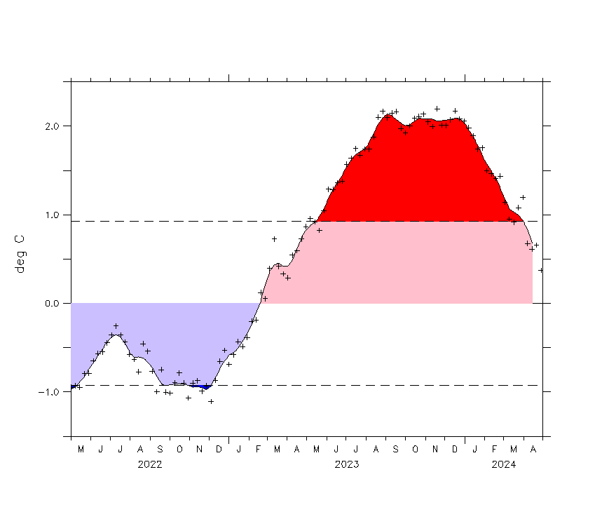
*Region 4 has declined by 0.37 deg C. and the decline is now constant.
nino4_short.gif


All indicators are that the peak has been reached and cooling is now the topic of the day.. Even the Blob has declined by a full degree C now and it continues to be pulled apart by the cold flows.

tpacv2.png


I firmly disagree with NOAA on their predictions for this one. And as a scientist it is my right to disagree. The pressures in the Alaska region are dropping rapidly and the water flows around the west coats are cooling rapidly.

But I'm sure Old fraud and others will come on here and ridicule because i dont conform to their religious dogma..
 
LOL. No, we will ridicule you because of the continued stupidity of your posts. You are not a scientist. In fact, I doubt that you have even seen the inside of a community college. Nobody can be as bone ignorant as you and have completed even a few 100 level courses.
 
Actually, it's the deniers who need to explain why they keep making up a phony story that global warming theory supposedly said more hurricanes would hit the USA.

Right there at the WhiteHouse Climate website..

And it clearly doesn't say anything about more hurricanes hitting the USA.

I won't try to guess your motives, so I'll just ask why you made that clearly incorrect claim. And I'll point out your best try was a swing and a miss, which doesn't hold much promise for any further attempts on your part.

climate_grey_quote.jpg


WE CAN CHOOSE TO BELIEVE THAT SUPERSTORM SANDY, AND THE MOST SEVERE DROUGHT IN DECADES, AND THE WORST WILDFIRES SOME STATES HAVE EVER SEEN WERE ALL JUST A FREAK COINCIDENCE. OR WE CAN CHOOSE TO BELIEVE IN THE OVERWHELMING JUDGMENT OF SCIENCE — AND ACT BEFORE IT'S TOO LATE."
- PRESIDENT OBAMA


You're welcome....

Hope you're too old for the SATs because your reading comprehension and logic skills sucks. The PREZ clearly implied we can't wait for MORE hurricanes caused by Global Warming -- before we act. AND if it WAS NOT a "freak coincidence" then it must be "SCIENCE". .

Apparently the community agitator BELIEVES (and is badgering us to believe) that it's the "OVERWHELMING JUDGEMENT OF SCIENCE" that says more GW caused hurricanes are on the way..
 
LOL. No, we will ridicule you because of the continued stupidity of your posts. You are not a scientist. In fact, I doubt that you have even seen the inside of a community college. Nobody can be as bone ignorant as you and have completed even a few 100 level courses.

You really are an ignorant fool who doesn't have a dam clue..

You profess to be going to school and yet you fail at every turn to understand basic scientific principals.. Your having an image problem... projecting your failures on others..
 
The latest weekly SST departures are:
Niño 4 1.4ºC
Niño 3.4 2.7ºC
Niño 3 2.8ºC
Niño 1+2 2.3ºC

Well, Billy, time to drop the pants again. 2.7. Now that is some cooling. Up 0.2 in a week.
 
Hurricane Patricia Recap: Strongest Landfalling Pacific Hurricane on Record

In addition to its unprecedented 200-mph (320-kph) sustained winds, Hurricane Patricia broke the record for lowest pressure in any hurricane on record. With a minimum central pressure of 880 millibars (25.99 inches of mercury) at the 4 a.m. CDT advisory Oct. 23, Patricia broke the record of 882 millibars set by Wilma in the Atlantic Basin almost exactly 10 years earlier. Around 1 p.m. CDT Oct. 23, the minimum central pressure reached its lowest point, 879 millibars (25.96 inches of mercury).

Data from an Air Force Hurricane Hunter airborne reconnaissance mission late on the night of Oct. 22 provided critical data demonstrating the extreme intensification of Hurricane Patricia in near-real time. A new NOAA reconnaissance aircraft reached the eye of Patricia early on the afternoon of Oct. 23 to gather additional direct measurements of the storm's intensity.

Unprecedented Among Pacific Hurricanes
Hurricane Patricia became the strongest Pacific hurricane on record shortly after midnight CDT early on Oct. 23. Air Force Hurricane Hunters had flown through the eye of Patricia and reported a sea-level pressure of 894 millibars as measured by a dropsonde inside the eye itself. Wind measurements suggested that the pressure measurement was not in the exact center of the eye and was probably not the absolute lowest pressure, prompting NHC to estimate the minimum central pressure at 892 millibars in its special 12:30 a.m. CDT advisory.

Tropical cyclone strength comparisons are typically based on minimum central pressure. At 892 millibars, Patricia shattered the Eastern Pacific basin's previous record of 902 millibars set by Hurricane Linda in 1997.

While a number of typhoons in the western North Pacific have been stronger, Patricia is now by far the strongest hurricane on record in any basin where the term "hurricane" applies to tropical cyclones – namely, the central and eastern North Pacific basins and the North Atlantic basin, which includes the North Atlantic Ocean itself plus the Gulf of Mexico and Caribbean Sea.

So there you have it, flap yap at the people that measure these things.
so I know what was different, Patricia was a Cat 5 that acted like a Cat 3, so, it didn't have the potential of a Cat 4 even though it was classified five. interesting eh?
How much does the ocean warming do to increase the power of storms? And how much more warming can we expect? What will the effect be on future El Nino's? How many times can we dodge the bullet?

Time to really do some serious research, for lives will depend on it. And it is hard to build the infrastructure we need for the future, when we are using our resources to rebuild from weather damage.
they already know how ocean temperatures will affect hurricanes, it up to mother nature. There are so many variables that it is too difficult for scientist to predict. too difficult.

excerpt from mit.edu:
"What are the problems with the current hurricane predictions?

There have been great strides forward made in the science of forecasting hurricanes, but there is still a lot to do. One major problem is accuracy. The National Hurricane Center has been forecasting the paths of hurricanes since the early 1950’s. They issue 120 hour, 96 hour, 72 hour, 48 hour, 24 hour, and 12 hour forecasts. (The 120 hour and 96 hour forecasts were introduced in 2003.) The error decreases as the time before landfall decreases. The error has also decreased over the years as models become more accurate (NOAA, 2004). Despite becoming more accurate, the error is still relatively large."

Link
Predicting Hurricanes
 
Hurricane Patricia Recap: Strongest Landfalling Pacific Hurricane on Record

In addition to its unprecedented 200-mph (320-kph) sustained winds, Hurricane Patricia broke the record for lowest pressure in any hurricane on record. With a minimum central pressure of 880 millibars (25.99 inches of mercury) at the 4 a.m. CDT advisory Oct. 23, Patricia broke the record of 882 millibars set by Wilma in the Atlantic Basin almost exactly 10 years earlier. Around 1 p.m. CDT Oct. 23, the minimum central pressure reached its lowest point, 879 millibars (25.96 inches of mercury).

Data from an Air Force Hurricane Hunter airborne reconnaissance mission late on the night of Oct. 22 provided critical data demonstrating the extreme intensification of Hurricane Patricia in near-real time. A new NOAA reconnaissance aircraft reached the eye of Patricia early on the afternoon of Oct. 23 to gather additional direct measurements of the storm's intensity.

Unprecedented Among Pacific Hurricanes
Hurricane Patricia became the strongest Pacific hurricane on record shortly after midnight CDT early on Oct. 23. Air Force Hurricane Hunters had flown through the eye of Patricia and reported a sea-level pressure of 894 millibars as measured by a dropsonde inside the eye itself. Wind measurements suggested that the pressure measurement was not in the exact center of the eye and was probably not the absolute lowest pressure, prompting NHC to estimate the minimum central pressure at 892 millibars in its special 12:30 a.m. CDT advisory.

Tropical cyclone strength comparisons are typically based on minimum central pressure. At 892 millibars, Patricia shattered the Eastern Pacific basin's previous record of 902 millibars set by Hurricane Linda in 1997.

While a number of typhoons in the western North Pacific have been stronger, Patricia is now by far the strongest hurricane on record in any basin where the term "hurricane" applies to tropical cyclones – namely, the central and eastern North Pacific basins and the North Atlantic basin, which includes the North Atlantic Ocean itself plus the Gulf of Mexico and Caribbean Sea.

So there you have it, flap yap at the people that measure these things.
so I know what was different, Patricia was a Cat 5 that acted like a Cat 3, so, it didn't have the potential of a Cat 4 even though it was classified five. interesting eh?
How much does the ocean warming do to increase the power of storms? And how much more warming can we expect? What will the effect be on future El Nino's? How many times can we dodge the bullet?

Time to really do some serious research, for lives will depend on it. And it is hard to build the infrastructure we need for the future, when we are using our resources to rebuild from weather damage.
they already know how ocean temperatures will affect hurricanes, it up to mother nature. There are so many variables that it is too difficult for scientist to predict. too difficult.

excerpt from mit.edu:
"What are the problems with the current hurricane predictions?

There have been great strides forward made in the science of forecasting hurricanes, but there is still a lot to do. One major problem is accuracy. The National Hurricane Center has been forecasting the paths of hurricanes since the early 1950’s. They issue 120 hour, 96 hour, 72 hour, 48 hour, 24 hour, and 12 hour forecasts. (The 120 hour and 96 hour forecasts were introduced in 2003.) The error decreases as the time before landfall decreases. The error has also decreased over the years as models become more accurate (NOAA, 2004). Despite becoming more accurate, the error is still relatively large."

Link
Predicting Hurricanes
Everything is too difficult if you are a stupid loser. By your own post the predictions have been getting more accurate. And the Europeans predictions are much more accurate than ours. As we get more reliable information, used to create more powerful models on ever more powerful computers, the predictions for 120 hours will become as accurate as our present predictions for 12 hours. And we will look further into the future, say 280 hours. Of course, chaos is a factor, so you are never going to find out which butterfly.
 
Now silly Billy, you have been saying exactly the same thing since the present El Nino was at 0.5. Now it is at 2.7, that is a super El Nino. Learn to use some bigger words, so your lies don't sound quite as stupid. Take lessons from Mr. Westwall.
 
Now silly Billy, you have been saying exactly the same thing since the present El Nino was at 0.5. Now it is at 2.7, that is a super El Nino. Learn to use some bigger words, so your lies don't sound quite as stupid. Take lessons from Mr. Westwall.

Still refusing to engage your brain...

At least your consistent..
 
El Niño 'is here, and it is huge,' as officials race to prep for winter

El Niño continues to gain strength in the Pacific Ocean, climate experts said, with unusually wet conditions expected to hit California between January and March -- and perhaps into May.

The latest forecast increased the urgency for both government agencies and property owners to prepare for possible flooding.

Local flood control agencies are busy clearing out storm drains, catch basins and other waterways.

In Los Angeles, the California Department of Transportation is increasing its maintenance staff by 25% through the winter months to deal with El Niño. The agency is stockpiling sandbags, readying plows and earth-moving equipment, and pruning trees and brush.

Still getting stronger. Measures being taken make sense.
 

Forum List

Back
Top